File:Barrier_route_July_2011.png
From Wikipedia, the free encyclopedia
Size of this preview: 218 × 599 pixels. Other resolutions: 87 × 240 pixels | 174 × 480 pixels | 279 × 768 pixels | 372 × 1,024 pixels | 745 × 2,048 pixels | 2,748 × 7,554 pixels.
Original file (2,748 × 7,554 pixels, file size: 2.48 MB, MIME type: image/png)
| This is a file from the Wikimedia Commons. Information from its description page there is shown below. Commons is a freely licensed media file repository. You can help. |
Summary
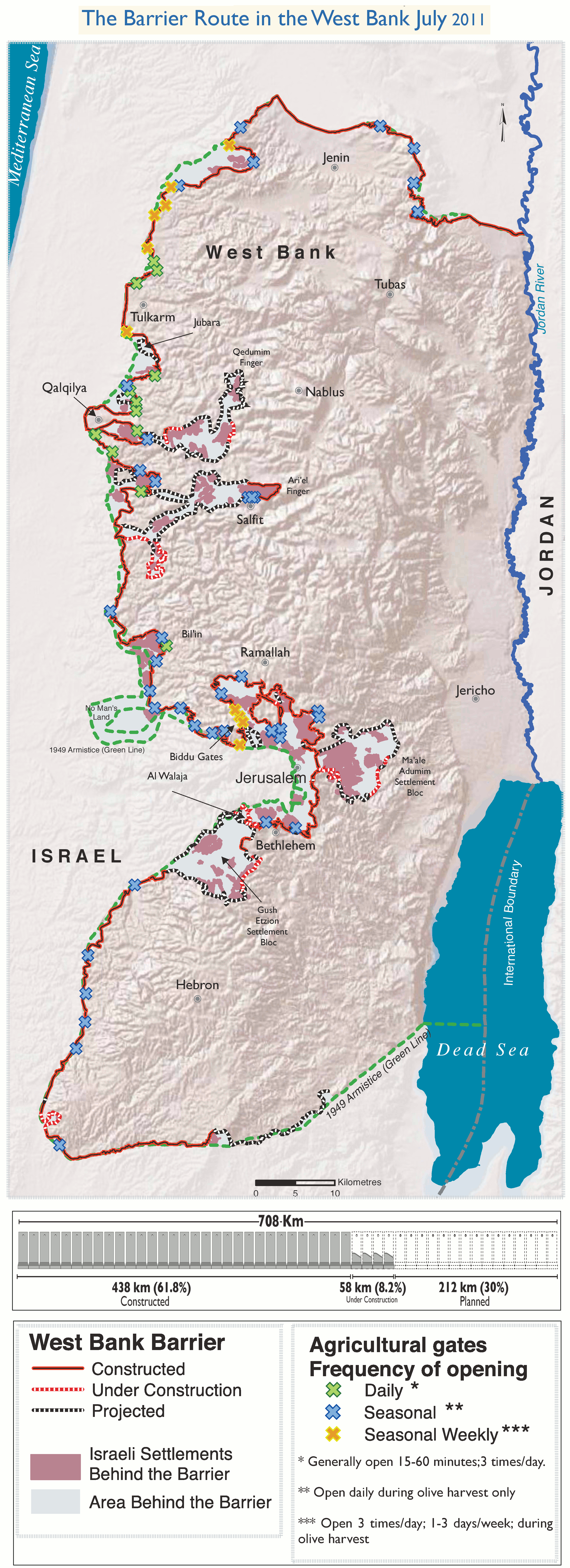
| DescriptionBarrier route July 2011.png |
English: The Israeli West Bank barrier as of July 2011.
The planned route, the part already completed, the part under construction as well as the Wall Gates where Palestinian access is controled by the Israeli army. |
| Date | |
| Source | Own work. Adaptation of http://www.ochaopt.org/documents/ocha_opt_west_bank_barrier_route_update_july_2011.pdf on OCHAoPt Map Centre. |
| Creator | |
| Georeferencing | Georeference the map in Wikimaps Warper If inappropriate please set warp_status = skip to hide. |
Licensing
I, the copyright holder of this work, hereby publish it under the following license:
This file is licensed under the Creative Commons Attribution 3.0 Unported license.
- You are free:
- to share – to copy, distribute and transmit the work
- to remix – to adapt the work
- Under the following conditions:
- attribution – You must give appropriate credit, provide a link to the license, and indicate if changes were made. You may do so in any reasonable manner, but not in any way that suggests the licensor endorses you or your use.

|
This image requires attribution, and is therefore not in the public domain. Reproduction and/or use of the original source is only permitted with express reference to “United Nations OCHA oPt” as the source. Please, delete UN name and logo upon any modification to the original. |
Captions
Add a one-line explanation of what this file represents
Items portrayed in this file
depicts
10 November 2013
image/png
7365a83095f090abfd51af95e67f327c1f14330c
2,596,428 byte
7,554 pixel
2,748 pixel
File history
Click on a date/time to view the file as it appeared at that time.
| Date/Time | Thumbnail | Dimensions | User | Comment | |
|---|---|---|---|---|---|
| current | 10:29, 10 November 2013 | 2,748 × 7,554 (2.48 MB) | Wickey-nl | User created page with UploadWizard |
File usage
The following pages on the English Wikipedia use this file (pages on other projects are not listed):
Global file usage
The following other wikis use this file:
- Usage on bn.wikipedia.org
- Usage on el.wikipedia.org
- Usage on eo.wikipedia.org
- Usage on fa.wikipedia.org
- Usage on fi.wikipedia.org
- Usage on fr.wikipedia.org
- Usage on ps.wikipedia.org
- Usage on pt.wikipedia.org
- Usage on sv.wikipedia.org
- Usage on tr.wikipedia.org
- Usage on zh.wikipedia.org
Metadata
This file contains additional information, probably added from the digital camera or scanner used to create or digitize it.
If the file has been modified from its original state, some details may not fully reflect the modified file.
| Horizontal resolution | 236.22 dpc |
|---|---|
| Vertical resolution | 236.22 dpc |
| File change date and time | 10:02, 10 November 2013 |
Retrieved from "https://en.wikipedia.org/wiki/File:Barrier_route_July_2011.png"