File:Antelope_Island_State_Park_Map.jpg
From Wikipedia, the free encyclopedia
Size of this preview: 400 × 600 pixels. Other resolutions: 160 × 240 pixels | 320 × 480 pixels | 512 × 768 pixels | 682 × 1,024 pixels | 2,500 × 3,750 pixels.
Original file (2,500 × 3,750 pixels, file size: 2.27 MB, MIME type: image/jpeg)
| This is a file from the Wikimedia Commons. Information from its description page there is shown below. Commons is a freely licensed media file repository. You can help. |
| This is a featured picture, which means that members of the community have identified it as one of the finest images on the English Wikipedia, adding significantly to its accompanying article. If you have a different image of similar quality, be sure to upload it using the proper free license tag, add it to a relevant article, and nominate it. |
| This image was selected as picture of the day on the English Wikipedia for November 2, 2008. |
|
Summary
| DescriptionAntelope Island State Park Map.jpg |
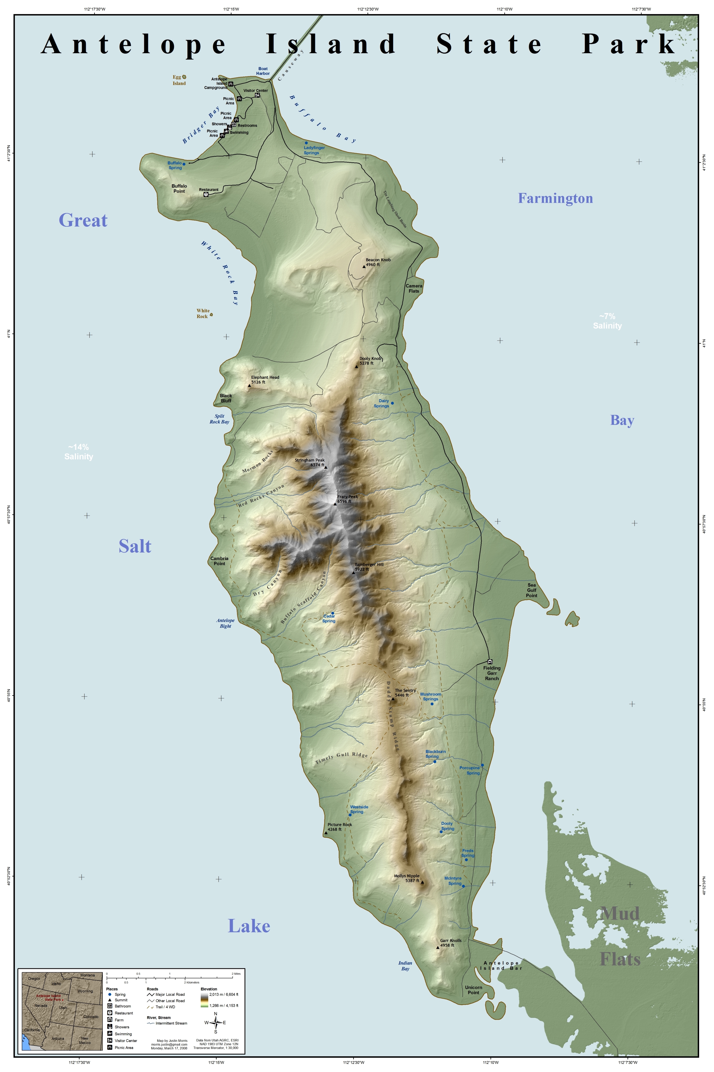
Map of Antelope Island State Park, Utah, Southwestern United States.
|
||
| Date | |||
| Source | This map was entirely self made using ArcGIS. Map data is from Utah AGRC, ESRI and the USGS. | ||
| Author | Justinmorris (talk) | ||
| Permission (Reusing this file) |
I, the copyright holder of this work, hereby publish it under the following license: This file is licensed under the Creative Commons Attribution-Share Alike 3.0 Unported license.
|
||
| Location InfoField | Antelope Island |
Captions
Add a one-line explanation of what this file represents
Items portrayed in this file
depicts
some value
9 March 2008
image/jpeg
a5f416c1103e413af435adad5fbcb0b4da639f48
2,381,918 byte
3,750 pixel
2,500 pixel
File history
Click on a date/time to view the file as it appeared at that time.
| Date/Time | Thumbnail | Dimensions | User | Comment | |
|---|---|---|---|---|---|
| current | 14:28, 17 March 2008 | | 2,500 × 3,750 (2.27 MB) | Justinmorris | Removed bathymetric representation. |
| 17:09, 16 March 2008 |  | 2,500 × 3,750 (2.32 MB) | Justinmorris | == Summary == {{Information |Description=Map of Antelope Island State Park, Utah, United States showing predominant features. |Source= {{User:Justinmorris/Source}} |Date=Sunday, March 9, 2008 |Location=Antelope Island |Author=[[User:Justinmorris|J |
File usage
The following pages on the English Wikipedia use this file (pages on other projects are not listed):
- Antelope Island
- Antelope Island bison herd
- Fielding Garr Ranch
- User:Gerry D/50 states
- User:Justinmorris
- User:Justinmorris/Credit
- User:Justinmorris/Maps
- User:Shubinator/Sandbox/Wikipedia Recent additions
- User talk:Justinmorris
- User talk:Justinmorris/Archive01
- Wikipedia:Did you know/Statistics/Monthly DYK pageview leaders/2010
- Wikipedia:Featured picture candidates/Antelope Island State Park Map.jpg
- Wikipedia:Featured picture candidates/April-2008
- Wikipedia:Featured pictures/Diagrams, drawings, and maps/Maps
- Wikipedia:Featured pictures thumbs/11
- Wikipedia:Picture of the day/November 2008
- Wikipedia:Picture peer review/Antelope Island State Park Map
- Wikipedia:Picture peer review/Archives/Jan-Mar 2008
- Wikipedia:Recent additions/2010/February
- Wikipedia:WikiProject United States/Featured pictures
- Wikipedia:WikiProject United States/Quality content
- Wikipedia:WikiProject United States/Recognized content
- Wikipedia:Wikipedia Signpost/2009-01-24/Dispatches
- Wikipedia talk:Wikipedia Signpost/2009-01-24/Dispatches
- Template:POTD/2008-11-02
- Portal:Geography/Featured picture/2009, week 20
- Portal:Geography/Featured picture archive/2009
- Portal:Maps/Selected picture
- Portal:Maps/Selected picture/40
- Portal:National Register of Historic Places/Portal picture
- Portal:National Register of Historic Places/Portal picture/16
- Portal:North America/Selected picture
- Portal:North America/Selected picture/31
- Portal:United States/Did you know/archive/2010/February
Global file usage
The following other wikis use this file:
- Usage on de.wikipedia.org
- Usage on es.wikipedia.org
- Usage on fr.wikipedia.org
- Usage on nl.wikipedia.org
- Usage on no.wikipedia.org
- Usage on pl.wikipedia.org
- Usage on sw.wikipedia.org
Metadata
This file contains additional information, probably added from the digital camera or scanner used to create or digitize it.
If the file has been modified from its original state, some details may not fully reflect the modified file.
| Horizontal resolution | 150 dpi |
|---|---|
| Vertical resolution | 150 dpi |
| Software used | Paint.NET v3.10 |