File:Antarctic_Region.png
From Wikipedia, the free encyclopedia
Size of this preview: 486 × 599 pixels. Other resolutions: 195 × 240 pixels | 389 × 480 pixels | 623 × 768 pixels | 830 × 1,024 pixels | 1,661 × 2,048 pixels | 2,787 × 3,437 pixels.
Original file (2,787 × 3,437 pixels, file size: 1.4 MB, MIME type: image/png)
| This is a file from the Wikimedia Commons. Information from its description page there is shown below. Commons is a freely licensed media file repository. You can help. |
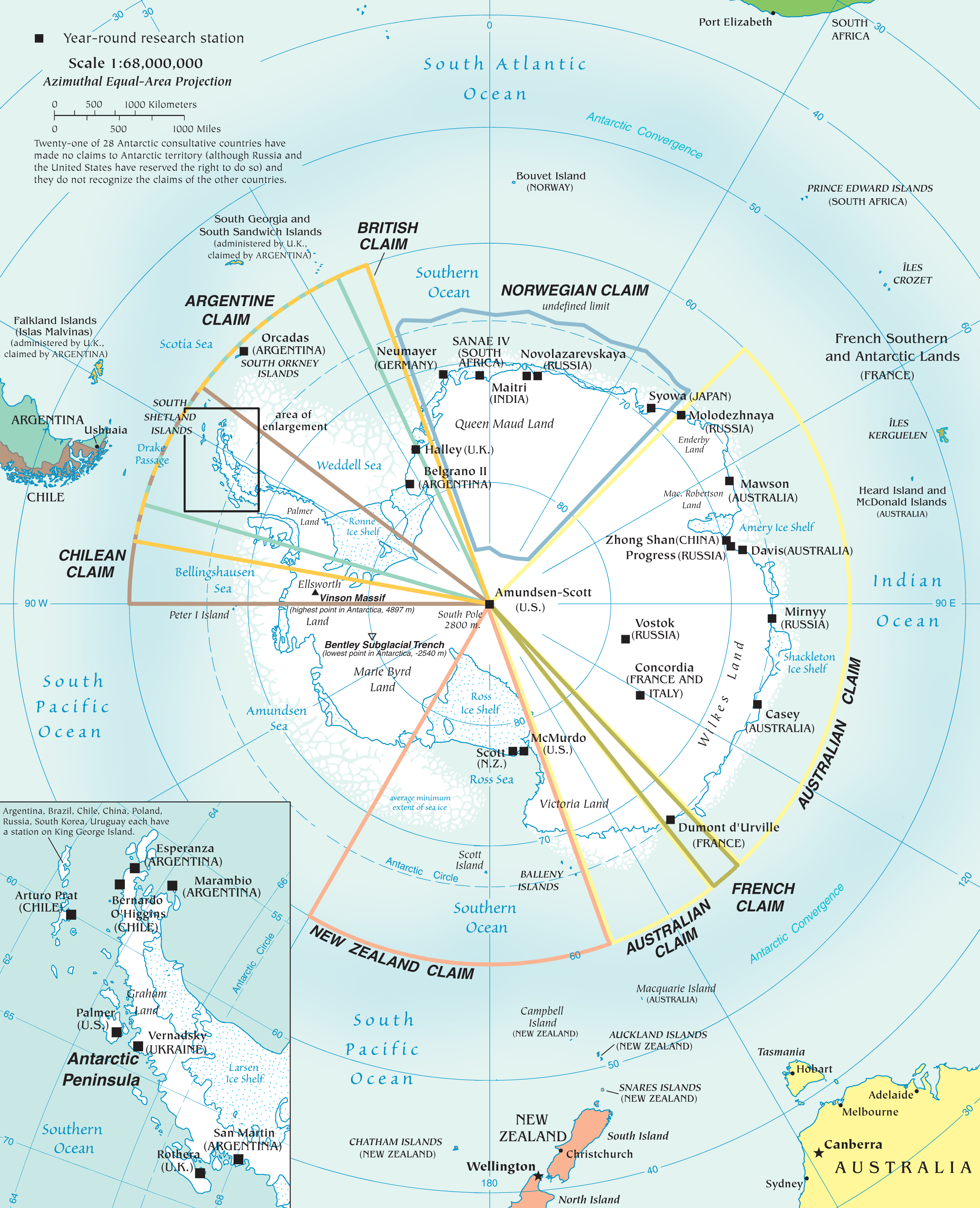
| DescriptionAntarctic Region.png |
English: Map of the antarctic region
Twenty-one of 28 Antarctic consultative countries have made no claims to Antarctic territory (although Russia and the United States have reserved the right to do so) and they do not recognize the claims of the other countries. Español: Mapa de la Antártida |
| Date | |
| Source | PDF at CIA Factbook |
| Author | The World Factbook |
| Public domainPublic domainfalsefalse |
This image is in the public domain because it contains materials that originally came from the United States Central Intelligence Agency's World Factbook.
Bahasa Indonesia ∙ čeština ∙ Deutsch ∙ eesti ∙ English ∙ español ∙ Esperanto ∙ français ∙ galego ∙ hrvatski ∙ italiano ∙ Nederlands ∙ norsk nynorsk ∙ polski ∙ português ∙ sicilianu ∙ slovenščina ∙ suomi ∙ Türkçe ∙ Zazaki ∙ беларуская (тарашкевіца) ∙ македонски ∙ русский ∙ српски / srpski ∙ українська ∙ ქართული ∙ বাংলা ∙ தமிழ் ∙ മലയാളം ∙ 한국어 ∙ 日本語 ∙ 中文 ∙ 中文(简体) ∙ 中文(繁體) ∙ العربية ∙ +/− |
 |
Captions
Add a one-line explanation of what this file represents
Items portrayed in this file
depicts
2 June 2009
image/png
1f272c1cd5b6aaace8df20b86ed849726407e8bd
1,468,065 byte
3,437 pixel
2,787 pixel
File history
Click on a date/time to view the file as it appeared at that time.
| Date/Time | Thumbnail | Dimensions | User | Comment | |
|---|---|---|---|---|---|
| current | 18:10, 3 December 2010 | | 2,787 × 3,437 (1.4 MB) | Ras67 | better arrangement of Antarctic Peninsula enlargement |
| 20:01, 2 December 2010 |  | 2,787 × 3,437 (1.4 MB) | Ras67 | {{Information |Description={{en|1=Map of the antarctic region<br /> Twenty-one of 28 Antarctic consultative countries have made no claims to Antarctic territory (although Russia and the United States have reserved the right to do so) and they do not recog |
File usage
The following pages on the English Wikipedia use this file (pages on other projects are not listed):
Global file usage
The following other wikis use this file:
- Usage on af.wikipedia.org
- Usage on an.wikipedia.org
- Usage on ar.wikipedia.org
- Usage on ast.wikipedia.org
- Usage on az.wikipedia.org
- Usage on be-tarask.wikipedia.org
- Usage on be.wikipedia.org
- Usage on ca.wikipedia.org
- Usage on cs.wikipedia.org
- Usage on de.wikipedia.org
- Usage on de.wikivoyage.org
- Usage on eo.wikipedia.org
- Usage on eu.wikipedia.org
- Usage on fr.wikipedia.org
- Usage on hi.wikipedia.org
- Usage on hu.wikipedia.org
- Usage on hy.wikipedia.org
- Usage on id.wikipedia.org
- Usage on ilo.wikipedia.org
- Usage on ja.wikipedia.org
- Usage on min.wikipedia.org
- Usage on ms.wikipedia.org
- Usage on nl.wikipedia.org
- Usage on nn.wikipedia.org
- Usage on ro.wikipedia.org
- Usage on su.wikipedia.org
- Usage on sv.wikipedia.org
- Usage on uk.wikipedia.org
- Usage on ur.wikipedia.org
View more global usage of this file.
Retrieved from "https://en.wikipedia.org/wiki/File:Antarctic_Region.png"