File:Ant-pen_map.png
From Wikipedia, the free encyclopedia
Size of this preview: 436 × 599 pixels. Other resolutions: 175 × 240 pixels | 349 × 480 pixels | 720 × 989 pixels.
Original file (720 × 989 pixels, file size: 233 KB, MIME type: image/png)
| This is a file from the Wikimedia Commons. Information from its description page there is shown below. Commons is a freely licensed media file repository. You can help. |
Summary
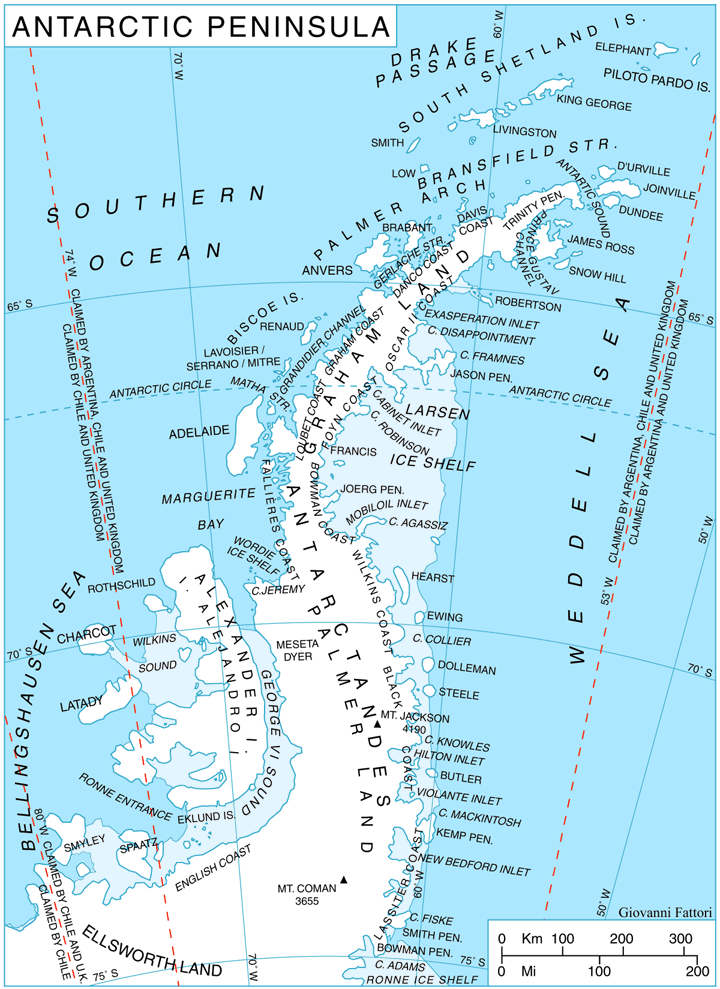
| DescriptionAnt-pen map.png | Antarctic Península map | |||||||||||||||||||||||
| Date | ||||||||||||||||||||||||
| Source | Own work | |||||||||||||||||||||||
| Author |
creator QS:P170,Q710089 |
|||||||||||||||||||||||
| Permission (Reusing this file) |
GNU free documentation | |||||||||||||||||||||||
| Other versions |
|
|||||||||||||||||||||||
,_by_Giovanni_Fattori.jpg)

Licensing

|
Permission is granted to copy, distribute and/or modify this document under the terms of the GNU Free Documentation License, Version 1.2 or any later version published by the Free Software Foundation; with no Invariant Sections, no Front-Cover Texts, and no Back-Cover Texts. A copy of the license is included in the section entitled GNU Free Documentation License.http://www.gnu.org/copyleft/fdl.htmlGFDLGNU Free Documentation Licensetruetrue |
| This file is licensed under the Creative Commons Attribution-Share Alike 3.0 Unported license. | ||
| ||
| This licensing tag was added to this file as part of the GFDL licensing update.http://creativecommons.org/licenses/by-sa/3.0/CC BY-SA 3.0Creative Commons Attribution-Share Alike 3.0truetrue |
Captions
Add a one-line explanation of what this file represents
Items portrayed in this file
depicts
6 May 2006
image/png
99f9af8ec558c1a7097fb17cbcfd74253af57641
238,608 byte
989 pixel
720 pixel
File history
Click on a date/time to view the file as it appeared at that time.
| Date/Time | Thumbnail | Dimensions | User | Comment | |
|---|---|---|---|---|---|
| current | 15:16, 8 April 2009 | | 720 × 989 (233 KB) | Mahahahaneapneap | Compressed |
| 18:51, 6 May 2006 |  | 720 × 989 (444 KB) | Gi | {{Information| |Description= Antarctic Península map |Source= |Date= 06-may-2006 |Author= Giovanni Fattori |Permission= GNU free documentation |other_versions= }} |
File usage
The following pages on the English Wikipedia use this file (pages on other projects are not listed):
Global file usage
The following other wikis use this file:
- Usage on ang.wikipedia.org
- Usage on ar.wikipedia.org
- Usage on ast.wikipedia.org
- Usage on az.wikipedia.org
- Usage on bar.wikipedia.org
- Usage on ba.wikipedia.org
- Usage on be.wikipedia.org
- Usage on bg.wikipedia.org
- Usage on bs.wikipedia.org
- Usage on ca.wikipedia.org
- Usage on ceb.wikipedia.org
- Usage on cs.wikipedia.org
- Usage on da.wikipedia.org
- Usage on de.wikipedia.org
- Usage on en.wikinews.org
- Usage on eo.wikipedia.org
- Usage on es.wikipedia.org
- Territorio Antártico Británico
- Archipiélago Palmer
- Islas Biscoe
- Barrera de hielo Larsen
- Isla Charcot
- Archipiélago de Joinville
- Isla Latady
- Islas Debenham
- Isla Petermann
- Mar de Bellingshausen
- Barrera de hielo Wilkins
- Islas Argentina
- Archipiélago Melchior
- Archipiélago Wilhelm
- Costa Bowman
- Costa Wilkins
- Costa Rymill
- Costa English
- Costa Black
View more global usage of this file.
Retrieved from "https://en.wikipedia.org/wiki/File:Ant-pen_map.png"