File:1842_Okkuddo_Cheonoquet_Anamickee_Shawwano_Oscoda_Negwegon_counties_Michigan.jpg
From Wikipedia, the free encyclopedia
Size of this preview: 800 × 520 pixels. Other resolutions: 320 × 208 pixels | 640 × 416 pixels | 810 × 527 pixels.
Original file (810 × 527 pixels, file size: 489 KB, MIME type: image/jpeg)
| This is a file from the Wikimedia Commons. Information from its description page there is shown below. Commons is a freely licensed media file repository. You can help. |
Summary
| Description1842 Okkuddo Cheonoquet Anamickee Shawwano Oscoda Negwegon counties Michigan.jpg |
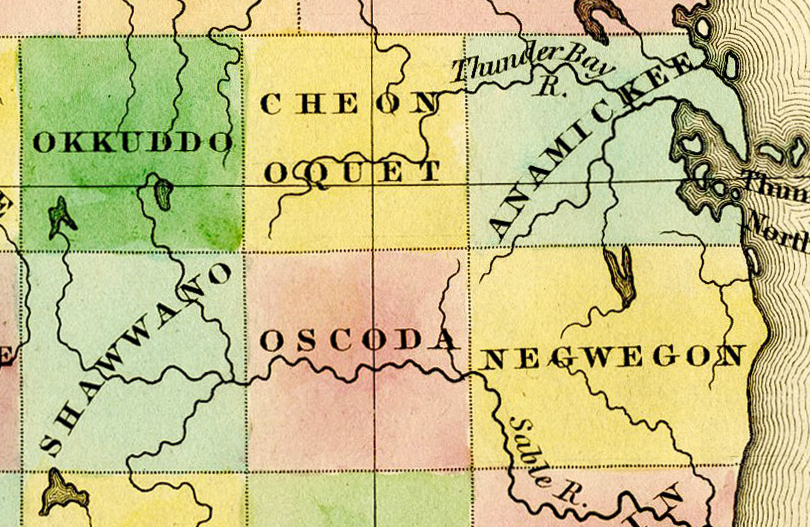
English: Detail of A New Map of Michigan With Its Canals, Roads & Distances by H.S. Tanner, 1842, showing:
|
|||||||||||||||||||
| Date | 1842, ©1841 | |||||||||||||||||||
| Source | File:1842 A new map of Michigan with its canals roads distances by H.S. Tanner.jpg | |||||||||||||||||||
| Author |
creator QS:P170,Q5728077 |
|||||||||||||||||||
| Other versions | File:1842 A new map of Michigan with its canals roads distances by H.S. Tanner.jpg | |||||||||||||||||||
Licensing
| Public domainPublic domainfalsefalse |
This media file is in the public domain in the United States. This applies to U.S. works where the copyright has expired, often because its first publication occurred prior to January 1, 1929, and if not then due to lack of notice or renewal. See this page for further explanation.
|
 | |
 |
This image might not be in the public domain outside of the United States; this especially applies in the countries and areas that do not apply the rule of the shorter term for US works, such as Canada, Mainland China (not Hong Kong or Macao), Germany, Mexico, and Switzerland. The creator and year of publication are essential information and must be provided. See Wikipedia:Public domain and Wikipedia:Copyrights for more details.
|
Captions
Add a one-line explanation of what this file represents
Items portrayed in this file
depicts
image/jpeg
65b5caf60581ae2707ac5b27fc00fcbd6ef77b43
500,563 byte
527 pixel
810 pixel
File history
Click on a date/time to view the file as it appeared at that time.
| Date/Time | Thumbnail | Dimensions | User | Comment | |
|---|---|---|---|---|---|
| current | 20:02, 5 October 2016 | | 810 × 527 (489 KB) | TimK MSI | {{Information |Description ={{en|1=Detail of A New Map of Michigan With Its Canals, Roads & Distances by H.S. Tanner, 1842 showing: *Okkuddo County (later rename... |
File usage
The following pages on the English Wikipedia use this file (pages on other projects are not listed):
Metadata
This file contains additional information, probably added from the digital camera or scanner used to create or digitize it.
If the file has been modified from its original state, some details may not fully reflect the modified file.
| Horizontal resolution | 300 dpi |
|---|---|
| Vertical resolution | 300 dpi |
| Software used | Adobe Photoshop Lightroom 5.7.1 (Windows) |
| File change date and time | 20:36, 4 October 2016 |
| Exif version | 2.3 |
| Date and time of digitizing | 15:33, 7 May 2014 |
| Unique ID of original document | B6372810F57136B4582AE829FB1BC012 |
| Date metadata was last modified | 16:36, 4 October 2016 |
| IIM version | 4 |