File:View_of_Kaikoura_Ranges,_New_Zealand.jpg
From Wikipedia, the free encyclopedia
Original file (7,071 × 2,886 pixels, file size: 16.78 MB, MIME type: image/jpeg)
| This is a file from the Wikimedia Commons. Information from its description page there is shown below. Commons is a freely licensed media file repository. You can help. |
Summary
| DescriptionView of Kaikoura Ranges, New Zealand.jpg |
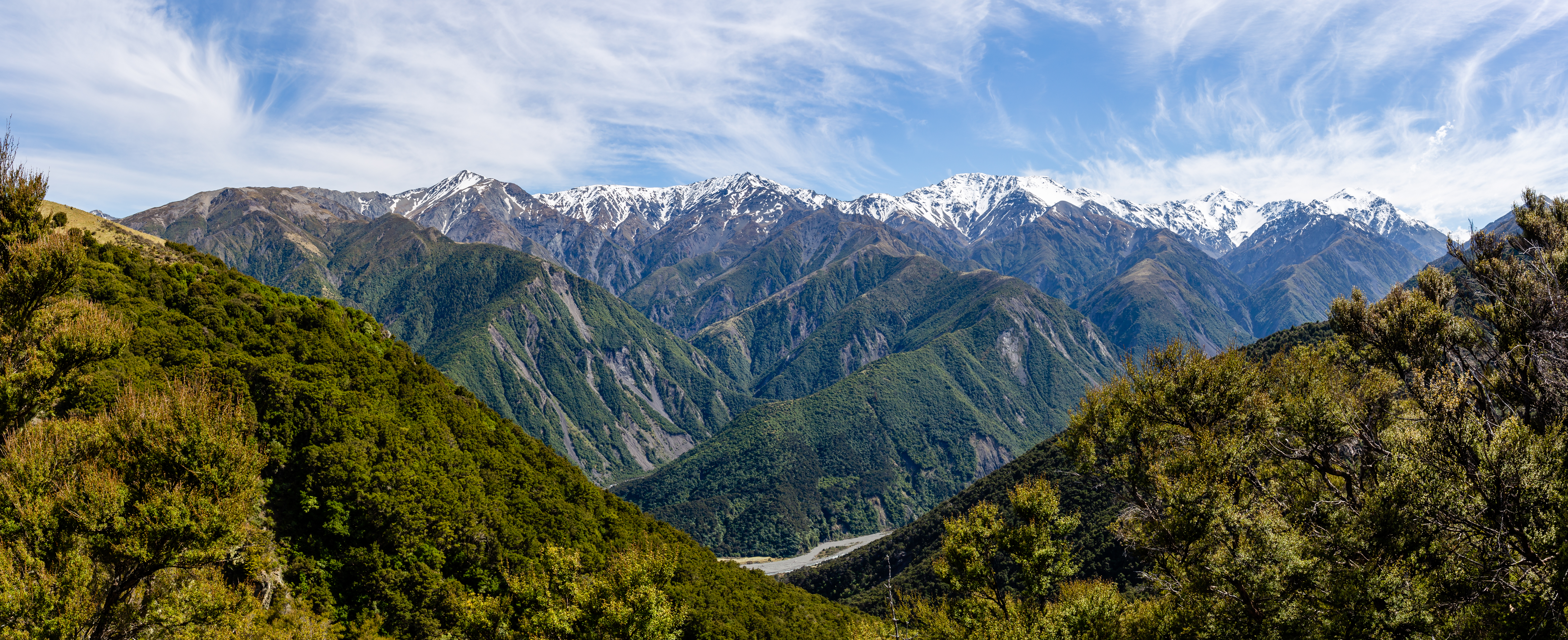
English: The picture was taken from the trail to Mt Fyffe and depicts Kowhai River at the bottom with the ranges West of Mt Fyffe. Kaikoura Ranges, New Zealand
Español: Vista de Kaikoura Ranges al oeste de Mt Fyffe en la región de Canterbury, Nueva Zelanda. El río Kowhai discurre en el fondo del valle.
Українська: Вид зі стежки на гору Файф на річку Ковгай внизу з хребтами на північний захід від гори Файф. Хребти Кайкоура (зліва направо, на горизонті) гори: Сновфлаке (1870 м), Пік 1984 м, Саундерс (2146 м), Манакау (2608 м), Уверау (2213 м). Нова Зеландія.
Magyar: A Fyffe-hegyre vezető ösvényről készült kép alul a Kowhai folyóval és a tőle nyugatra eső hegyláncokkal (Kaikoura-hegység, Déli-sziget, Új-Zéland)
Македонски: Венецот Каикоура и реката Кофаи, Нов Зеланд
Português: Vista da cordilheira Kaikoura a oeste do monte Fyffe na região de Canterbury, Nova Zelândia. O rio Kowhai corre no fundo do vale.
Bosanski: Slika snimljena sa staze ka Mt Fyffe i prikazuje rijeku Kowhai na dnu sa planinskim lancima zapadno od Mt Fyffe. Planinski lanac Kaikōura, Novi Zeland
Эрзянь: Фотокувось теезь янстонть кона вети Файфф пандтненень ды невти Ковай леенть ало ды пандо карязонть чивалгома ёнов. Каикоура пандокарязт, Од Зеландия. |
|||
| Date | ||||
| Source | Own work | |||
| Author | Michal Klajban | |||
| Other versions |
|
|
This image was selected as picture of the day on Wikimedia Commons for 6 May 2021. It was captioned as follows: English: The picture was taken from the trail to Mt Fyffe and depicts Kowhai River at the bottom with the ranges West of Mt Fyffe. Kaikoura Ranges, New Zealand Other languages:
Bosanski: Slika snimljena sa staze ka Mt Fyffe i prikazuje rijeku Kowhai na dnu sa planinskim lancima zapadno od Mt Fyffe. Planinski lanac Kaikōura, Novi Zeland Čeština: Snímek části pohoří Kaikoura Ranges nad řekou Kowhai River na novozélandském Jižním ostrově. English: The picture was taken from the trail to Mt Fyffe and depicts Kowhai River at the bottom with the ranges West of Mt Fyffe. Kaikoura Ranges, New Zealand Español: Vista de Kaikoura Ranges al oeste de Mt Fyffe en la región de Canterbury, Nueva Zelanda. El río Kowhai discurre en el fondo del valle. Magyar: A Fyffe-hegyre vezető ösvényről készült kép alul a Kowhai folyóval és a tőle nyugatra eső hegyláncokkal (Kaikoura-hegység, Déli-sziget, Új-Zéland) Português: Vista da cordilheira Kaikoura a oeste do monte Fyffe na região de Canterbury, Nova Zelândia. O rio Kowhai corre no fundo do vale. Македонски: Венецот Каикоура и реката Кофаи, Нов Зеланд العربية : تم التقاط الصورة من الطريق المؤدي إلى جبل فايف وتصور نهر كوهاي في الأسفل مع سلاسل غرب جبل فيفي. كايكورا رينجز، نيوزيلندا. |
| Camera location | 42° 19′ 46.39″ S, 173° 34′ 52.98″ E | View this and other nearby images on: OpenStreetMap |
|---|
The production, editing or release of this file was supported by the Community-Budget of Wikimedia Deutschland. To see other files made with the support of Wikimedia Deutschland, please see the category Supported by Wikimedia Deutschland. العربية ∙ বাংলা ∙ Deutsch ∙ English ∙ Esperanto ∙ français ∙ magyar ∙ Bahasa Indonesia ∙ italiano ∙ 日本語 ∙ македонски ∙ മലയാളം ∙ Bahasa Melayu ∙ Nederlands ∙ português ∙ русский ∙ slovenščina ∙ svenska ∙ українська ∙ தமிழ் ∙ +/−
|
Licensing
- You are free:
- to share – to copy, distribute and transmit the work
- to remix – to adapt the work
- Under the following conditions:
- attribution – You must give appropriate credit, provide a link to the license, and indicate if changes were made. You may do so in any reasonable manner, but not in any way that suggests the licensor endorses you or your use.
- share alike – If you remix, transform, or build upon the material, you must distribute your contributions under the same or compatible license as the original.
| Annotations InfoField | This image is annotated: View the annotations at Commons |
Peak 1984 m
Mount Sounders
(2146 m)
Mount Snowflake
(1870 m)
This image has been assessed using the Quality image guidelines and is considered a Quality image.
العربية ∙ جازايرية ∙ беларуская ∙ беларуская (тарашкевіца) ∙ български ∙ বাংলা ∙ català ∙ čeština ∙ Cymraeg ∙ Deutsch ∙ Schweizer Hochdeutsch ∙ Zazaki ∙ Ελληνικά ∙ English ∙ Esperanto ∙ español ∙ eesti ∙ euskara ∙ فارسی ∙ suomi ∙ français ∙ galego ∙ עברית ∙ हिन्दी ∙ hrvatski ∙ magyar ∙ հայերեն ∙ Bahasa Indonesia ∙ italiano ∙ 日本語 ∙ Jawa ∙ ქართული ∙ 한국어 ∙ kurdî ∙ Lëtzebuergesch ∙ lietuvių ∙ македонски ∙ മലയാളം ∙ मराठी ∙ Bahasa Melayu ∙ Nederlands ∙ Norfuk / Pitkern ∙ polski ∙ português ∙ português do Brasil ∙ rumantsch ∙ română ∙ русский ∙ sicilianu ∙ slovenčina ∙ slovenščina ∙ shqip ∙ српски / srpski ∙ svenska ∙ தமிழ் ∙ తెలుగు ∙ ไทย ∙ Tagalog ∙ Türkçe ∙ toki pona ∙ українська ∙ vèneto ∙ Tiếng Việt ∙ 中文 ∙ 中文(简体) ∙ 中文(繁體) ∙ +/− |
Captions
Items portrayed in this file
depicts
20 October 2019
42°19'46.391"S, 173°34'52.979"E
0.008 second
11
24 millimetre
100
File history
Click on a date/time to view the file as it appeared at that time.
| Date/Time | Thumbnail | Dimensions | User | Comment | |
|---|---|---|---|---|---|
| current | 04:16, 10 November 2019 | 7,071 × 2,886 (16.78 MB) | Podzemnik | small tweaks | |
| 20:15, 2 November 2019 | 7,312 × 2,984 (15.4 MB) | Podzemnik | User created page with UploadWizard |
File usage
Global file usage
The following other wikis use this file:
- Usage on alt.wikipedia.org
- Usage on av.wikipedia.org
- Usage on be-tarask.wikipedia.org
- Usage on crh.wikipedia.org
- Usage on cs.wikipedia.org
- Usage on cv.wikipedia.org
- Usage on el.wiktionary.org
- Usage on fa.wikipedia.org
- Usage on fr.wikipedia.org
- Usage on hu.wikipedia.org
- Usage on hy.wikipedia.org
- Usage on it.wiktionary.org
- Usage on ka.wikipedia.org
- Usage on ko.wikipedia.org
- Usage on ku.wikipedia.org
- Usage on lbe.wikipedia.org
- Usage on lez.wikipedia.org
- Usage on mk.wikipedia.org
- Usage on os.wikipedia.org
- Usage on pt.wikipedia.org
- Usage on ru.wikipedia.org
- Usage on ru.wikinews.org
- Usage on sah.wikipedia.org
- Usage on uk.wikipedia.org
- Usage on vep.wikipedia.org
- Usage on vi.wikipedia.org
- Usage on zh.wikipedia.org
Metadata
This file contains additional information, probably added from the digital camera or scanner used to create or digitize it.
If the file has been modified from its original state, some details may not fully reflect the modified file.
| Camera manufacturer | Canon |
|---|---|
| Camera model | Canon EOS 6D |
| Author | Michal Klajban |
| Exposure time | 1/125 sec (0.008) |
| F-number | f/11 |
| ISO speed rating | 100 |
| Date and time of data generation | 10:19, 20 October 2019 |
| Lens focal length | 24 mm |
| Horizontal resolution | 240 dpi |
| Vertical resolution | 240 dpi |
| Software used | Adobe Photoshop Lightroom Classic 8.1 (Windows) |
| File change date and time | 17:14, 10 November 2019 |
| Exposure Program | Manual |
| Exif version | 2.3 |
| Date and time of digitizing | 10:19, 20 October 2019 |
| Shutter speed | 6.965784 |
| APEX aperture | 6.918863 |
| Exposure bias | 0 |
| Maximum land aperture | 4 APEX (f/4) |
| Metering mode | Pattern |
| Flash | Flash did not fire, compulsory flash suppression |
| DateTimeOriginal subseconds | 731 |
| Color space | sRGB |
| Focal plane X resolution | 1,520 |
| Focal plane Y resolution | 1,520 |
| Focal plane resolution unit | 3 |
| Custom image processing | Normal process |
| Exposure mode | Manual exposure |
| White balance | Auto white balance |
| Scene capture type | Standard |
| Serial number of camera | 252154000131 |
| Lens used | EF24-70mm f/4L IS USM |
| Date metadata was last modified | 06:14, 11 November 2019 |
| Unique ID of original document | ABD66459505542E23258524D20EE888D |
| Contact information | michal.klajban@gmail.com
|
| IIM version | 4 |