File:Ustyurt_Plateau.png
From Wikipedia, the free encyclopedia
No higher resolution available.
Ustyurt_Plateau.png (613 × 460 pixels, file size: 514 KB, MIME type: image/png)
| This is a file from the Wikimedia Commons. Information from its description page there is shown below. Commons is a freely licensed media file repository. You can help. |
Summary
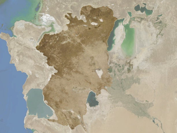
| DescriptionUstyurt Plateau.png |
Français : Le plateau d'Oust-Ourt en surbrillance entre les mers Caspienne et d'Aral, entre le Kazakhstan, l'Ouzbékistan et le Kirghizistan. English: Ustyurt Plateau highlighted between Caspian and Aral seas in Kazakhstan, Uzbekistan and Kyrgyzstan. |
| Date | |
| Source | Cropped and colorised version of File:Kyzyl Kum.png |
| Author | NASA World Wind |
| Other versions | File:Kyzyl Kum.png |
| Camera location | 43° 21′ 00″ N, 56° 12′ 00″ E | View this and other nearby images on: OpenStreetMap |
|---|
Licensing
| Public domainPublic domainfalsefalse |
| This image is in the public domain because it is a screenshot from NASA’s globe software World Wind using a public domain layer, such as Blue Marble, MODIS, Landsat, SRTM, USGS or GLOBE.
العربيَّة | English | فارسی | français | עברית | македонски | മലയാളം | Nederlands | русский | 中文(中国大陆) | +/− |
 |
Captions
Add a one-line explanation of what this file represents
Items portrayed in this file
depicts
14 October 2012
43°21'0"N, 56°12'0"E
image/png
8aa4d57f87001d65aab96e82d389aeaf5bad738d
526,125 byte
460 pixel
613 pixel
File history
Click on a date/time to view the file as it appeared at that time.
| Date/Time | Thumbnail | Dimensions | User | Comment | |
|---|---|---|---|---|---|
| current | 14:15, 14 October 2012 | | 613 × 460 (514 KB) | Rémih | User created page with UploadWizard |
File usage
The following pages on the English Wikipedia use this file (pages on other projects are not listed):
Global file usage
The following other wikis use this file:
- Usage on ar.wikipedia.org
- Usage on az.wikipedia.org
- Usage on be.wikipedia.org
- Usage on bg.wikipedia.org
- Usage on ca.wikipedia.org
- Usage on ceb.wikipedia.org
- Usage on es.wikipedia.org
- Usage on eu.wikipedia.org
- Usage on fa.wikipedia.org
- Usage on fr.wikipedia.org
- Usage on he.wikipedia.org
- Usage on hr.wikipedia.org
- Usage on hu.wikipedia.org
- Usage on id.wikipedia.org
- Usage on it.wikipedia.org
- Usage on kk.wikipedia.org
- Usage on ko.wikipedia.org
- Usage on ky.wikipedia.org
- Usage on lt.wikipedia.org
- Usage on mt.wikipedia.org
- Usage on pl.wikipedia.org
- Usage on ru.wikipedia.org
- Usage on uk.wikipedia.org
- Usage on uz.wikipedia.org
- Usage on www.wikidata.org
Metadata
This file contains additional information, probably added from the digital camera or scanner used to create or digitize it.
If the file has been modified from its original state, some details may not fully reflect the modified file.
| Horizontal resolution | 28.34 dpc |
|---|---|
| Vertical resolution | 28.34 dpc |
| File change date and time | 14:04, 14 October 2012 |
Retrieved from "https://en.wikipedia.org/wiki/File:Ustyurt_Plateau.png"