File:Syrdaryamap.png
From Wikipedia, the free encyclopedia
Size of this preview: 719 × 600 pixels. Other resolutions: 288 × 240 pixels | 576 × 480 pixels | 820 × 684 pixels.
Original file (820 × 684 pixels, file size: 936 KB, MIME type: image/png)
| This is a file from the Wikimedia Commons. Information from its description page there is shown below. Commons is a freely licensed media file repository. You can help. |
Summary

|
This map image could be re-created using vector graphics as an SVG file. This has several advantages; see Commons:Media for cleanup for more information. If an SVG form of this image is available, please upload it and afterwards replace this template with
{{vector version available|new image name}}.
It is recommended to name the SVG file “Syrdaryamap.svg”—then the template Vector version available (or Vva) does not need the new image name parameter. |
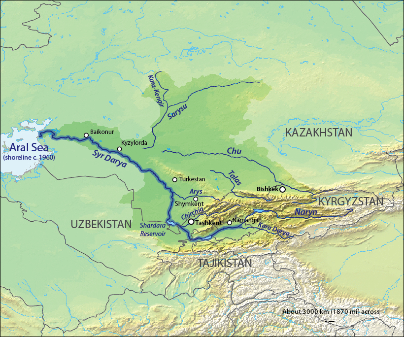
| DescriptionSyrdaryamap.png |
English: Map of the Syr Darya Basin watershed, of the Syr Darya and Chu Rivers — in Central Asia.
Қазақша: Сырдария
Татарча / tatarça: Сырдәрья |
| Date | to 06 |
| Source | Background and river course data from http://www2.demis.nl/mapserver/mapper.asp |
| Author | Background layer attributed to DEMIS Mapserver, map created by Shannon1 |
| Permission (Reusing this file) |
Map created from DEMIS Mapserver, which are public domain. |
| Other versions |
Derivative works of this file: |
Licensing
I, the copyright holder of this work, hereby publish it under the following licenses:

|
Permission is granted to copy, distribute and/or modify this document under the terms of the GNU Free Documentation License, Version 1.2 or any later version published by the Free Software Foundation; with no Invariant Sections, no Front-Cover Texts, and no Back-Cover Texts. A copy of the license is included in the section entitled GNU Free Documentation License.http://www.gnu.org/copyleft/fdl.htmlGFDLGNU Free Documentation Licensetruetrue |
This file is licensed under the Creative Commons Attribution-Share Alike Attribution-Share Alike 4.0 International, 3.0 Unported, 2.5 Generic, 2.0 Generic and 1.0 Generic license.
- You are free:
- to share – to copy, distribute and transmit the work
- to remix – to adapt the work
- Under the following conditions:
- attribution – You must give appropriate credit, provide a link to the license, and indicate if changes were made. You may do so in any reasonable manner, but not in any way that suggests the licensor endorses you or your use.
- share alike – If you remix, transform, or build upon the material, you must distribute your contributions under the same or compatible license as the original.
You may select the license of your choice.
Captions
Add a one-line explanation of what this file represents
Items portrayed in this file
depicts
5 February 2010
File history
Click on a date/time to view the file as it appeared at that time.
| Date/Time | Thumbnail | Dimensions | User | Comment | |
|---|---|---|---|---|---|
| current | 03:11, 18 October 2013 | | 820 × 684 (936 KB) | Shannon1 | redrew and fixed watershed boundary |
| 09:21, 8 January 2011 |  | 1,101 × 866 (1.65 MB) | Sibom | chu | |
| 09:20, 8 January 2011 |  | 1,101 × 866 (1.65 MB) | Sibom | чу | |
| 03:04, 7 February 2010 |  | 1,101 × 866 (1.51 MB) | Shannon1 | {{Information |Description={{en|1=Map of the watershed of the Syr Darya in Central Asia, that drains to the Aral Sea.}} |Source=Background and river course data from http://www2.demis.nl/mapserver/mapper.asp |Author=Background layer attributed to DEMIS M |
File usage
The following pages on the English Wikipedia use this file (pages on other projects are not listed):
Global file usage
The following other wikis use this file:
- Usage on af.wikipedia.org
- Usage on ar.wikipedia.org
- Usage on ast.wikipedia.org
- Usage on bg.wikipedia.org
- Usage on bh.wikipedia.org
- Usage on bn.wikipedia.org
- Usage on cs.wikipedia.org
- Usage on cv.wikipedia.org
- Usage on da.wikipedia.org
- Usage on de.wikipedia.org
- Usage on es.wikipedia.org
- Usage on et.wikipedia.org
- Usage on fi.wikipedia.org
- Usage on fr.wikipedia.org
- Usage on he.wikipedia.org
- Usage on hi.wikipedia.org
- Usage on hr.wikipedia.org
- Usage on hu.wikipedia.org
- Usage on hy.wikipedia.org
- Usage on id.wikipedia.org
- Usage on incubator.wikimedia.org
- Usage on io.wikipedia.org
- Usage on it.wikipedia.org
- Usage on ja.wikipedia.org
View more global usage of this file.
Metadata
This file contains additional information, probably added from the digital camera or scanner used to create or digitize it.
If the file has been modified from its original state, some details may not fully reflect the modified file.
| Horizontal resolution | 28.35 dpc |
|---|---|
| Vertical resolution | 28.35 dpc |
Retrieved from "https://en.wikipedia.org/wiki/File:Syrdaryamap.png"