File:NC_Punt.jpg
From Wikipedia, the free encyclopedia
No higher resolution available.
NC_Punt.jpg (400 × 400 pixels, file size: 77 KB, MIME type: image/jpeg)
| This is a file from the Wikimedia Commons. Information from its description page there is shown below. Commons is a freely licensed media file repository. You can help. |
Summary
| DescriptionNC Punt.jpg |
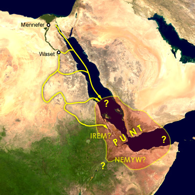
English: Map of the supposed location of Punt and trade routes from Egypt to Punt via rivers, wadis, and by sea. Mennefer is Memphis, Waset is Thebes, Irem and Nemyw are lands that supposedly border on Punt |
| Date | 30 November 2009 (original upload date) |
| Source | Transferred from en.wikipedia to Commons. |
| Author | Cush at English Wikipedia |
Licensing
| Public domainPublic domainfalsefalse |
| This work has been released into the public domain by its author, Cush at English Wikipedia. This applies worldwide. In some countries this may not be legally possible; if so: Cush grants anyone the right to use this work for any purpose, without any conditions, unless such conditions are required by law.Public domainPublic domainfalsefalse |
This compound image uses free material land_shallow_topo_east.tif from NASA Visible Earth (formerly "Blue Marble") and world.200407.3x21600x21600.C1.png from JULY, BLUE MARBLE NEXT GENERATION
Original upload log
The original description page was here. All following user names refer to en.wikipedia.
- 2009-11-30 00:57 Cush 400×400× (79081 bytes) Map of the supposed location of Punt
Captions
Add a one-line explanation of what this file represents
Items portrayed in this file
depicts
30 November 2009
image/jpeg
File history
Click on a date/time to view the file as it appeared at that time.
| Date/Time | Thumbnail | Dimensions | User | Comment | |
|---|---|---|---|---|---|
| current | 03:33, 22 October 2023 | | 400 × 400 (77 KB) | Cush | Reverted to version as of 13:38, 28 February 2011 (UTC) Punt is considered to be on either side of the Bab-el-Mandeb |
| 15:37, 29 September 2023 |  | 400 × 400 (68 KB) | Bidiieyahaneko | Due weight, majority of scholarly sources place Punt in Africa | |
| 13:38, 28 February 2011 |  | 400 × 400 (77 KB) | Freetrashbox | {{Information |Description={{en|Map of the supposed location of Punt}} |Source=Transferred from [http://en.wikipedia.org en.wikipedia] |Date={{Date|2009|11|30}} (original upload date) |Author=Original uploader was Cush at [http://en.wiki |
File usage
The following pages on the English Wikipedia use this file (pages on other projects are not listed):
Global file usage
The following other wikis use this file:
- Usage on am.wikipedia.org
- Usage on ar.wikipedia.org
- Usage on bn.wikipedia.org
- Usage on ca.wikipedia.org
- Usage on en.wiktionary.org
- Usage on es.wikipedia.org
- Usage on fr.wikipedia.org
- Usage on hu.wikipedia.org
- Usage on ja.wikipedia.org
- Usage on lv.wikipedia.org
- Usage on ru.wikipedia.org
- Usage on ru.wiktionary.org
- Usage on simple.wikipedia.org
- Usage on sr.wikipedia.org
Retrieved from "https://en.wikipedia.org/wiki/File:NC_Punt.jpg"