File:Map_Bolivia_territorial_loss-en.jpg
From Wikipedia, the free encyclopedia

Map_Bolivia_territorial_loss-en.jpg (471 × 447 pixels, file size: 56 KB, MIME type: image/jpeg)
| This is a file from the Wikimedia Commons. Information from its description page there is shown below. Commons is a freely licensed media file repository. You can help. |

|
File:Map Bolivia territorial loss-en.svg is a vector version of this file. It should be used in place of this JPG file when not inferior.
File:Map Bolivia territorial loss-en.jpg → File:Map Bolivia territorial loss-en.svg
For more information, see Help:SVG.
|
 |
Summary
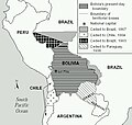
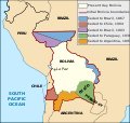
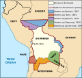
Taken from PDF file: http://lcweb2.loc.gov/frd/cs/bolivia/bo01_05a.pdf Converted by uploader The file is part of the Library of Congress Country Study on Bolivia
Other versions: [edit]
-
 English (JPEG original)
 -
 English
 -
 español
 -
 français
 -
 magyar
 -
 македонски
 -
 српски / srpski


Licensing
| Public domainPublic domainfalsefalse |
This work is in the public domain in the United States because it is a work prepared by an officer or employee of the United States Government as part of that person’s official duties under the terms of Title 17, Chapter 1, Section 105 of the US Code.
Note: This only applies to original works of the Federal Government and not to the work of any individual U.S. state, territory, commonwealth, county, municipality, or any other subdivision. This template also does not apply to postage stamp designs published by the United States Postal Service since 1978. (See § 313.6(C)(1) of Compendium of U.S. Copyright Office Practices). It also does not apply to certain US coins; see The US Mint Terms of Use.
|
 | |
| This file has been identified as being free of known restrictions under copyright law, including all related and neighboring rights. | ||
https://creativecommons.org/publicdomain/mark/1.0/PDMCreative Commons Public Domain Mark 1.0falsefalse
derivative works
Derivative works of this file: Map Bolivia territorial loss-en.svg
File history
Click on a date/time to view the file as it appeared at that time.
| Date/Time | Thumbnail | Dimensions | User | Comment | |
|---|---|---|---|---|---|
| current | 22:10, 24 January 2006 | | 471 × 447 (56 KB) | Bkwillwm | Category:Maps of Bolivia Category:LOC Wikiproject Taken from PDF file: http://lcweb2.loc.gov/frd/cs/bolivia/bo01_05a.pdf Converted by uploader The file is part of the Library of Congress Country Study on Bolivia |
File usage
Global file usage
The following other wikis use this file:
- Usage on en.wikibooks.org
- Usage on es.wikipedia.org
- Usage on fr.wikipedia.org
Metadata
This file contains additional information, probably added from the digital camera or scanner used to create or digitize it.
If the file has been modified from its original state, some details may not fully reflect the modified file.
| _error | 0 |
|---|