File:Locator_EH-MA-MR-DZ.png
From Wikipedia, the free encyclopedia
No higher resolution available.
Locator_EH-MA-MR-DZ.png (300 × 300 pixels, file size: 6 KB, MIME type: image/png)
| This is a file from the Wikimedia Commons. Information from its description page there is shown below. Commons is a freely licensed media file repository. You can help. |
Summary
| DescriptionLocator EH-MA-MR-DZ.png |
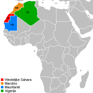
English: Locator map for the Western Sahara, Morocco, Mauritania and Algeria.
Nederlands: Locatiekaart voor de Westelijke Sahara, Marokko, Mauritanië en Algerije. |
| Date | |
| Source | Own work |
| Author | Egs |
| Other versions | BlankMap-World-v2.png, Algeria Morocco Locator.png |
Licensing
I, the copyright holder of this work, hereby publish it under the following licenses:

|
Permission is granted to copy, distribute and/or modify this document under the terms of the GNU Free Documentation License, Version 1.2 or any later version published by the Free Software Foundation; with no Invariant Sections, no Front-Cover Texts, and no Back-Cover Texts. A copy of the license is included in the section entitled GNU Free Documentation License.http://www.gnu.org/copyleft/fdl.htmlGFDLGNU Free Documentation Licensetruetrue |
This file is licensed under the Creative Commons Attribution-Share Alike 3.0 Unported, 2.5 Generic, 2.0 Generic and 1.0 Generic license.
- You are free:
- to share – to copy, distribute and transmit the work
- to remix – to adapt the work
- Under the following conditions:
- attribution – You must give appropriate credit, provide a link to the license, and indicate if changes were made. You may do so in any reasonable manner, but not in any way that suggests the licensor endorses you or your use.
- share alike – If you remix, transform, or build upon the material, you must distribute your contributions under the same or compatible license as the original.
You may select the license of your choice.
Captions
Add a one-line explanation of what this file represents
Items portrayed in this file
depicts
4 July 2009
File history
Click on a date/time to view the file as it appeared at that time.
| Date/Time | Thumbnail | Dimensions | User | Comment | |
|---|---|---|---|---|---|
| current | 11:37, 4 July 2009 | | 300 × 300 (6 KB) | Egs | {{Information |Description={{en|1=Locator map for the Western Sahara, Morocco, Mauritania and Algeria.}} {{nl|1=Locatiekaart voor de Westelijke Sahara, Marokko, Mauritanië en Algerije.}} |Source=eigen werk (own work) |Author=Egs |Date=04 jul |
File usage
The following pages on the English Wikipedia use this file (pages on other projects are not listed):
Global file usage
The following other wikis use this file:
- Usage on ar.wikipedia.org
- Usage on ca.wikipedia.org
- Usage on ckb.wikipedia.org
- Usage on fa.wikipedia.org
- Usage on id.wikipedia.org
- Usage on mzn.wikipedia.org
- Usage on nl.wikipedia.org
- Usage on ru.wikipedia.org
- Usage on www.wikidata.org
Retrieved from "https://en.wikipedia.org/wiki/File:Locator_EH-MA-MR-DZ.png"