File:First_Series_OS_map_showing_Great_Boughton_and_Chester_in_1856.png
From Wikipedia, the free encyclopedia
No higher resolution available.
First_Series_OS_map_showing_Great_Boughton_and_Chester_in_1856.png (492 × 339 pixels, file size: 497 KB, MIME type: image/png)
| This is a file from the Wikimedia Commons. Information from its description page there is shown below. Commons is a freely licensed media file repository. You can help. |
Summary
| DescriptionFirst Series OS map showing Great Boughton and Chester in 1856.png |
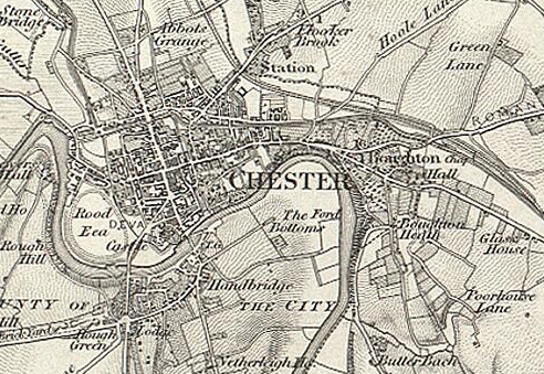
English: This early Ordnance Survey map shows Great Boughton as being a much smaller settlement just to the east of the city of Chester. |
| Date | |
| Source | http://www.visionofbritain.org.uk/maps/sheet/first_edition/sht80 |
| Author | Ordnance Survey |
| Camera location | 53° 11′ 00″ N, 2° 52′ 00″ W | View this and other nearby images on: OpenStreetMap |
|---|
Licensing
This file is licensed under the Creative Commons Attribution-Share Alike 4.0 International license.
- You are free:
- to share – to copy, distribute and transmit the work
- to remix – to adapt the work
- Under the following conditions:
- attribution – You must give appropriate credit, provide a link to the license, and indicate if changes were made. You may do so in any reasonable manner, but not in any way that suggests the licensor endorses you or your use.
- share alike – If you remix, transform, or build upon the material, you must distribute your contributions under the same or compatible license as the original.
Captions
Add a one-line explanation of what this file represents
Items portrayed in this file
depicts
53°10'59.999"N, 2°52'0.001"W
1856
image/png
File history
Click on a date/time to view the file as it appeared at that time.
| Date/Time | Thumbnail | Dimensions | User | Comment | |
|---|---|---|---|---|---|
| current | 10:37, 23 January 2015 | | 492 × 339 (497 KB) | Humphrey.Southall | User created page with UploadWizard |
File usage
The following pages on the English Wikipedia use this file (pages on other projects are not listed):