File:Cemmaes_Road_station_building,_platform_side_-_geograph.org.uk_-_1068739.jpg
From Wikipedia, the free encyclopedia
No higher resolution available.
Cemmaes_Road_station_building,_platform_side_-_geograph.org.uk_-_1068739.jpg (640 × 431 pixels, file size: 98 KB, MIME type: image/jpeg)
| This is a file from the Wikimedia Commons. Information from its description page there is shown below. Commons is a freely licensed media file repository. You can help. |
Summary
| DescriptionCemmaes Road station building, platform side - geograph.org.uk - 1068739.jpg |
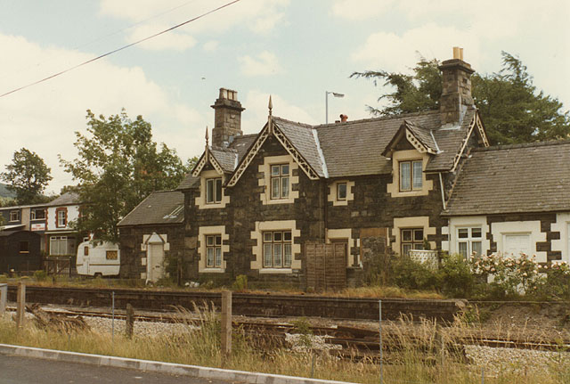
English: Cemmaes Road station building, platform side Taken after it had been converted into residential accommodation. The central building (which the square boundary passes through) was the stationmaster's accommodation, while the building partly visible on the right was the booking office and waiting room. Very solid stone construction was used for all the stations of the Newtown & Machynlleth Railway. The road visible in the foreground had just been built, to avoid the need for a level crossing to the west of the station. |
| Date | |
| Source | From geograph.org.uk |
| Author | Nigel Brown |
| Attribution (required by the license) InfoField | Nigel Brown / Cemmaes Road station building, platform side / |
InfoField | Nigel Brown / Cemmaes Road station building, platform side |
| Camera location | 52° 37′ 29″ N, 3° 44′ 44″ W | View this and other nearby images on: OpenStreetMap |
|---|
| Object location | 52° 37′ 28″ N, 3° 44′ 42″ W | View this and other nearby images on: OpenStreetMap |
|---|
Licensing

|
This image was taken from the Geograph project collection. See this photograph's page on the Geograph website for the photographer's contact details. The copyright on this image is owned by Nigel Brown and is licensed for reuse under the Creative Commons Attribution-ShareAlike 2.0 license.
|
This file is licensed under the Creative Commons Attribution-Share Alike 2.0 Generic license.
Attribution: Nigel Brown
- You are free:
- to share – to copy, distribute and transmit the work
- to remix – to adapt the work
- Under the following conditions:
- attribution – You must give appropriate credit, provide a link to the license, and indicate if changes were made. You may do so in any reasonable manner, but not in any way that suggests the licensor endorses you or your use.
- share alike – If you remix, transform, or build upon the material, you must distribute your contributions under the same or compatible license as the original.
Captions
Add a one-line explanation of what this file represents
Items portrayed in this file
depicts
some value
52°37'28.63"N, 3°44'43.80"W
September 1982
52°37'27.70"N, 3°44'41.64"W
image/jpeg
1fa27f6ecb90de99c40c651e15b7010a19de7b4a
100,385 byte
431 pixel
640 pixel
File history
Click on a date/time to view the file as it appeared at that time.
| Date/Time | Thumbnail | Dimensions | User | Comment | |
|---|---|---|---|---|---|
| current | 03:37, 24 February 2011 | | 640 × 431 (98 KB) | GeographBot | == {{int:filedesc}} == {{Information |description={{en|1=Cemmaes Road station building, platform side Taken after it had been converted into residential accommodation. The central building (which the square boundary passes through) was the stationmaster's |
File usage
The following pages on the English Wikipedia use this file (pages on other projects are not listed):
Global file usage
The following other wikis use this file:
- Usage on fi.wikipedia.org
- Usage on www.wikidata.org
Metadata
This file contains additional information, probably added from the digital camera or scanner used to create or digitize it.
If the file has been modified from its original state, some details may not fully reflect the modified file.
| Orientation | Normal |
|---|---|
| Horizontal resolution | 400 dpi |
| Vertical resolution | 400 dpi |
| Software used | Adobe Photoshop Elements 2.0 |
| File change date and time | 00:22, 4 December 2008 |
| Color space | Uncalibrated |