File:C2C-route.png
From Wikipedia, the free encyclopedia
No higher resolution available.
C2C-route.png (192 × 251 pixels, file size: 63 KB, MIME type: image/png)
| This is a file from the Wikimedia Commons. Information from its description page there is shown below. Commons is a freely licensed media file repository. You can help. |
Summary
| DescriptionC2C-route.png |
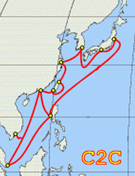
English: Entire route of the C2C submarine communications cable. Landing points are shown by yellow and black circles. For more information, see main article. |
| Source | No machine-readable source provided. Own work assumed (based on copyright claims). |
| Author | No machine-readable author provided. J.P.Lon~commonswiki assumed (based on copyright claims). |
Licensing
I, the copyright holder of this work, hereby publish it under the following licenses:

|
Permission is granted to copy, distribute and/or modify this document under the terms of the GNU Free Documentation License, Version 1.2 or any later version published by the Free Software Foundation; with no Invariant Sections, no Front-Cover Texts, and no Back-Cover Texts. A copy of the license is included in the section entitled GNU Free Documentation License.http://www.gnu.org/copyleft/fdl.htmlGFDLGNU Free Documentation Licensetruetrue |
| This file is licensed under the Creative Commons Attribution-Share Alike 3.0 Unported license. | ||
| ||
| This licensing tag was added to this file as part of the GFDL licensing update.http://creativecommons.org/licenses/by-sa/3.0/CC BY-SA 3.0Creative Commons Attribution-Share Alike 3.0truetrue |
This file is licensed under the Creative Commons Attribution 2.5 Generic license.
- You are free:
- to share – to copy, distribute and transmit the work
- to remix – to adapt the work
- Under the following conditions:
- attribution – You must give appropriate credit, provide a link to the license, and indicate if changes were made. You may do so in any reasonable manner, but not in any way that suggests the licensor endorses you or your use.
You may select the license of your choice.
Captions
Add a one-line explanation of what this file represents
Items portrayed in this file
depicts
image/png
14206b40a4637e9603451b34867f39ed77a9a999
64,784 byte
251 pixel
192 pixel
File history
Click on a date/time to view the file as it appeared at that time.
| Date/Time | Thumbnail | Dimensions | User | Comment | |
|---|---|---|---|---|---|
| current | 03:19, 9 July 2015 | | 192 × 251 (63 KB) | Cwek | According to [http://www.submarinecablemap.com/#/submarine-cable/eac-c2c] ,C2C have no the side of North American. |
| 01:52, 22 January 2007 |  | 541 × 251 (84 KB) | J.P.Lon~commonswiki | Entire route of the C2C Submarine communications cable. Landing points are not shown by yellow and black circles. For more information, see main article. |
File usage
The following pages on the English Wikipedia use this file (pages on other projects are not listed):
Global file usage
The following other wikis use this file:
- Usage on zh.wikipedia.org
Metadata
This file contains additional information, probably added from the digital camera or scanner used to create or digitize it.
If the file has been modified from its original state, some details may not fully reflect the modified file.
| Horizontal resolution | 28.33 dpc |
|---|---|
| Vertical resolution | 28.33 dpc |
| File change date and time | 01:48, 22 January 2007 |
Retrieved from "https://en.wikipedia.org/wiki/File:C2C-route.png"