Loading AI tools
Dubyna (Ukrainian: Ду́бина, Polish: Dębina) is a village (selo) in Stryi Raion, Lviv Oblast, of Western Ukraine. It belongs to Skole urban hromada, one of the hromadas of Ukraine.[1]
Dubyna
Ду́бина | |
|---|---|
 Dubyna | |
| Coordinates: 49°03′39″N 23°32′47″E | |
| Country | |
| Province | |
| District | Stryi Raion |
| Established | 1561 |
| Area | |
| • Total | 061 km2 (24 sq mi) |
| Elevation /(average value of) | 428 m (1,404 ft) |
| Population | |
| • Total | 276 |
| Time zone | UTC+2 (EET) |
| • Summer (DST) | UTC+3 (EEST) |
| Postal code | 82614 |
| Area code | +380 3251 |
| Website | селище Верхнє Синьовидне (Ukrainian) |
The village is located on the banks of the Opir River along the Highway M06 (Ukraine) (![]() M 06).
M 06).
It is situated 105 kilometres (65 mi) from the regional center Lviv, 4 kilometres (2.5 mi) from the district center Skole, and 163 kilometres (101 mi) from Uzhhorod.
Local government — Verkhnosynovydnenska settlement council.[2]
The first written mention of the village dates from the year 1561 and the name of the village is derived from the surrounding oak forests (dubovyy lis).[3]
Until 18 July 2020, Dubyna belonged to Skole Raion. The raion was abolished in July 2020 as part of the administrative reform of Ukraine, which reduced the number of raions of Lviv Oblast to seven. The area of Skole Raion was merged into Stryi Raion.[4][5]
- Solomiya Krushelnytska (1872 – 1952) – Ukrainian opera singer, was one of the brightest soprano opera stars of the first half of the 20th century.[6]
- Myroslav Skoryk (1938) – Ukrainian composer and teacher, People's Artist of Ukraine, winner of the Prize Shevchenko.
 Wooden house in the village Dubyna.
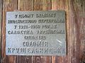 Krushelnytska Solomiya plaque in memory
 Krushelnytsky – Okhrymovych families cottage house.


Wikiwand in your browser!
Seamless Wikipedia browsing. On steroids.
Every time you click a link to Wikipedia, Wiktionary or Wikiquote in your browser's search results, it will show the modern Wikiwand interface.
Wikiwand extension is a five stars, simple, with minimum permission required to keep your browsing private, safe and transparent.