Dori, Burkina Faso
Place in Sahel Region, Burkina Faso From Wikipedia, the free encyclopedia
Place in Sahel Region, Burkina Faso From Wikipedia, the free encyclopedia
Dori (also known as Winde or Wendu[2]) is a town in northeastern Burkina Faso, near the border of Niger. It is located at around 14.03°N 0.03°W. It is the capital of Sahel Region and has a population of 46,512 (2019).[1] The main ethnic group is the Fula (Fulani) but Tuaregs and Songhai are often present. It is a town known for its herders and popular livestock markets.[3]
Dori | |
|---|---|
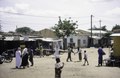
 A farmer on the streets of Dori | |
| Nickname: 1 | |
 Dori Location within Burkina Faso, French West Africa | |
| Coordinates: 14.03°N 0.03°W | |
| Country | |
| Region | Sahel Region |
| Province | Séno Province |
| Elevation | 286 m (938 ft) |
| Population (2019 census)[1] | |
| • Total | 46,512 |
| Time zone | UTC+0 (GMT) |
Dori recorded a temperature of 47.2 °C (117.0 °F) in 1984, which is the highest temperature to have ever been recorded in Burkina Faso.[4]
In 2020, it was reported that the Emir of Liptako lived in Dori.[5]
| Climate data for Dori (1991–2020) | |||||||||||||
|---|---|---|---|---|---|---|---|---|---|---|---|---|---|
| Month | Jan | Feb | Mar | Apr | May | Jun | Jul | Aug | Sep | Oct | Nov | Dec | Year |
| Record high °C (°F) | 40.8 (105.4) |
43.5 (110.3) |
44.6 (112.3) |
47.5 (117.5) |
46.4 (115.5) |
45.0 (113.0) |
42.3 (108.1) |
41.1 (106.0) |
42.6 (108.7) |
42.6 (108.7) |
41.6 (106.9) |
39.9 (103.8) |
47.5 (117.5) |
| Mean daily maximum °C (°F) | 32.6 (90.7) |
36.0 (96.8) |
40.0 (104.0) |
42.4 (108.3) |
41.8 (107.2) |
38.8 (101.8) |
35.5 (95.9) |
33.7 (92.7) |
35.9 (96.6) |
38.9 (102.0) |
37.6 (99.7) |
33.9 (93.0) |
37.3 (99.1) |
| Daily mean °C (°F) | 23.6 (74.5) |
26.8 (80.2) |
31.0 (87.8) |
34.2 (93.6) |
34.6 (94.3) |
32.4 (90.3) |
29.7 (85.5) |
28.3 (82.9) |
29.6 (85.3) |
31.0 (87.8) |
28.0 (82.4) |
24.5 (76.1) |
29.5 (85.1) |
| Mean daily minimum °C (°F) | 15.5 (59.9) |
18.4 (65.1) |
22.6 (72.7) |
26.7 (80.1) |
28.8 (83.8) |
27.2 (81.0) |
25.0 (77.0) |
24.1 (75.4) |
24.8 (76.6) |
24.8 (76.6) |
19.4 (66.9) |
16.1 (61.0) |
22.8 (73.0) |
| Record low °C (°F) | 7.8 (46.0) |
10.7 (51.3) |
14.0 (57.2) |
16.4 (61.5) |
20.6 (69.1) |
20.8 (69.4) |
18.7 (65.7) |
19.8 (67.6) |
19.9 (67.8) |
17.8 (64.0) |
12.9 (55.2) |
8.3 (46.9) |
7.8 (46.0) |
| Average precipitation mm (inches) | 0.3 (0.01) |
0.0 (0.0) |
2.6 (0.10) |
4.8 (0.19) |
25.7 (1.01) |
68.3 (2.69) |
127.9 (5.04) |
186.9 (7.36) |
73.8 (2.91) |
16.7 (0.66) |
0.0 (0.0) |
0.0 (0.0) |
507.0 (19.96) |
| Average precipitation days (≥ 1.0 mm) | 0.1 | 0.0 | 0.2 | 0.5 | 3.0 | 5.2 | 8.9 | 10.6 | 6.7 | 2.2 | 0.0 | 0.0 | 37.4 |
| Mean monthly sunshine hours | 281.3 | 255.8 | 264.7 | 254.2 | 265.6 | 245.9 | 245.4 | 237.5 | 249.2 | 280.0 | 288.4 | 291.9 | 3,159.9 |
| Source: NOAA[6] | |||||||||||||
In 2004, a proposal surfaced to link the manganese mines by rail with the seaports of Ghana.[7]


Seamless Wikipedia browsing. On steroids.
Every time you click a link to Wikipedia, Wiktionary or Wikiquote in your browser's search results, it will show the modern Wikiwand interface.
Wikiwand extension is a five stars, simple, with minimum permission required to keep your browsing private, safe and transparent.