Curemonte
Commune in Nouvelle-Aquitaine, France From Wikipedia, the free encyclopedia
Curemonte (French pronunciation: [kyʁmɔ̃t]; Limousin: Curamonta) is a commune in the Corrèze department in central France. It is a medieval village characterised by its three castles. In a fortified position on a ridge overlooking a valley on both its eastern and western flanks, the village has historically had a strategic importance in the area. Its inhabitants are called Curemontois.
You can help expand this article with text translated from the corresponding article in French. (January 2009) Click [show] for important translation instructions.
|
Curemonte | |
|---|---|
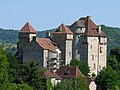
 The Château des Plas, in Curemonte | |
.svg) Coat of arms | |
Location of Curemonte  | |
 Curemonte  Curemonte | |
| Coordinates: 45°00′00″N 1°44′27″E | |
| Country | France |
| Region | Nouvelle-Aquitaine |
| Department | Corrèze |
| Arrondissement | Brive-la-Gaillarde |
| Canton | Midi Corrézien |
| Intercommunality | Midi Corrézien |
| Government | |
| • Mayor (2020–2026) | Nelly Germane[1] |
| Area 1 | 8.83 km2 (3.41 sq mi) |
| Population (2021)[2] | 212 |
| • Density | 24/km2 (62/sq mi) |
| Time zone | UTC+01:00 (CET) |
| • Summer (DST) | UTC+02:00 (CEST) |
| INSEE/Postal code | 19067 /19500 |
| Elevation | 143 m (469 ft) |
| 1 French Land Register data, which excludes lakes, ponds, glaciers > 1 km2 (0.386 sq mi or 247 acres) and river estuaries. | |
Toponymy
The name for Curemonte is derived from low Latin Cura montis meaning a location used for an operating estate that's on a mountain or hill.[3]: 25
History
The existence of Curemonte is confirmed from as early as 860 when it was mentioned in the Cartulaire de l'Abbaye de Beaulieu.[3]: 25 Rodolphe de Turenne, Archbishop of Bourges, had donated the village of Saint-Genst and its vineyards at Curemonte to the Abbey of Beaulieu.[3]: 25
It was in the 11th century that the village flourished, passing through the Viscounts of Turenne.
Geography
Location
The municipality of Curemonte is located at the southern end of the department of Corrèze.

Map of the commune.
Physical geography
The village of Curemonte is built on a ridge line that overlooks the valleys of the Sourdoire and the Maumont.
Demographics
| Year | Pop. | ±% p.a. |
|---|---|---|
| 1968 | 311 | — |
| 1975 | 248 | −3.18% |
| 1982 | 231 | −1.01% |
| 1990 | 203 | −1.60% |
| 1999 | 225 | +1.15% |
| 2009 | 213 | −0.55% |
| 2014 | 216 | +0.28% |
| 2020 | 208 | −0.63% |
| Source: INSEE[4] | ||
Places and monuments
- It is ranked among the most beautiful villages in France.
- It has three castles:
- It has three churches:
- Church of Saint-Barthélemy du Bourg;
- Church of Saint-Hilaire de la Combe: 11th Century Romanesque church, one of the oldest in the department, which was probably built on Merovingian foundations;
- The church of Saint-Genest: former parish church, now a Museum of Religious Art.
 Châteaux de Plas et de Saint-Hilaire.
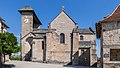 Church of Saint-Barthélemy.
 Church of Saint-Hilaire de la Combe.


See also
References
Wikiwand in your browser!
Seamless Wikipedia browsing. On steroids.
Every time you click a link to Wikipedia, Wiktionary or Wikiquote in your browser's search results, it will show the modern Wikiwand interface.
Wikiwand extension is a five stars, simple, with minimum permission required to keep your browsing private, safe and transparent.