
Chop–Tysa
From Wikipedia, the free encyclopedia
Chop–Tysa[1] is a land border crossing between Ukraine and Hungary on the Ukrainian side, near the village of Solomonovo, Uzhhorod Raion, Zakarpattia Oblast.
Quick Facts Cho –Tysa, Location ...
| Cho –Tysa | |
|---|---|
| Location | |
| Country | Ukraine |
| Location | Solomonovo, Uzhhorod Raion, Zakarpattia Oblast |
| Coordinates | 48.418431°N 22.170222°E / 48.418431; 22.170222 |
| Details | |
| Hours | Open 24 Hours |
| Statistics | |
Close
- For the city, see Chop, Ukraine.
The crossing is situated on Highway M06. Across the border on the Hungarian side is the town of Zahony, Szabolcs-Szatmár-Bereg County, Northern Great Plain.
The type of crossing is automobile. The types of transportation for automobile crossings are passenger and freight. Pedestrian and bicycle movement is closed.[2]
The port of entry is part of the Tysa customs post of Chop customs.
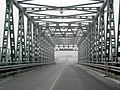 Bridge over Tysa viewing the Hungarian side
