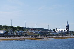
Baie-des-Sables is a municipality in La Matanie Regional County Municipality in the Bas-Saint-Laurent region of Quebec, Canada.
Baie-des-Sables | |
|---|---|
 | |
 Location within La Matanie RCM. | |
| Coordinates: 48°43′N 67°51′W[1] | |
| Country | |
| Province | |
| Region | Bas-Saint-Laurent |
| RCM | La Matanie |
| Constituted | January 1, 1859 |
| Government | |
| • Mayor | Marie-Claude Saucier |
| • Federal riding | Haute-Gaspésie—La Mitis—Matane—Matapédia |
| • Prov. riding | Matane-Matapédia |
| Area | |
| • Total | 64.80 km2 (25.02 sq mi) |
| • Land | 65.07 km2 (25.12 sq mi) |
| There is an apparent contradiction between two authoritative sources | |
| Population | |
| • Total | 613 |
| • Density | 9.4/km2 (24/sq mi) |
| • Pop 2016-2021 | |
| • Dwellings | 336 |
| Time zone | UTC−5 (EST) |
| • Summer (DST) | UTC−4 (EDT) |
| Postal code(s) | |
| Area codes | 418 and 581 |
| Highways | |
| Website | municipalite |
Its elevation is 577 ft.[citation needed]
Demographics
| 2021 | 2016 | 2011 | |
|---|---|---|---|
| Population | 613 (-2.4% from 2016) | 628 (3.1% from 2011) | 609 (-0.8% from 2006) |
| Land area | 65.07 km2 (25.12 sq mi) | 65.19 km2 (25.17 sq mi) | 65.48 km2 (25.28 sq mi) |
| Population density | 9.4/km2 (24/sq mi) | 9.6/km2 (25/sq mi) | 9.3/km2 (24/sq mi) |
| Median age | 56.0 (M: 56.4, F: 56.0) | 51.9 (M: 51.7, F: 52.5) | 48.5 (M: 47.5, F: 48.96) |
| Private dwellings | 336 (total) 281 (occupied) | 328 (total) | 277 (total) |
| Median household income | $58,000 | $51,840 | $48,415 |
See also
References
Wikiwand in your browser!
Seamless Wikipedia browsing. On steroids.
Every time you click a link to Wikipedia, Wiktionary or Wikiquote in your browser's search results, it will show the modern Wikiwand interface.
Wikiwand extension is a five stars, simple, with minimum permission required to keep your browsing private, safe and transparent.

