
Băicoi
Town in Prahova, Romania / From Wikipedia, the free encyclopedia
Dear Wikiwand AI, let's keep it short by simply answering these key questions:
Can you list the top facts and stats about Băicoi?
Summarize this article for a 10 year old
Băicoi (Romanian pronunciation: [bəjˈkoj]) is a town in Prahova County, Romania, near the 45th parallel. Five localities are administered by the town: Dâmbu, Liliești, Schela, Tufeni, and Țintea. Over time, these have become neighborhoods of the town.[3]
Băicoi | |
|---|---|
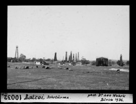 Băicoi oilfield, 1936 | |
 Coat of arms | |
 Location in Prahova County | |
 Băicoi Location in Romania | |
| Coordinates: 45°2′43″N 25°51′57″E | |
| Country | Romania |
| County | Prahova |
| Government | |
| • Mayor (2020–2024) | Marius Constantin[1] (PSD) |
| Area | 65.36 km2 (25.24 sq mi) |
| Highest elevation | 310 m (1,020 ft) |
| Lowest elevation | 285 m (935 ft) |
| Population (2021-12-01)[2] | 16,722 |
| • Density | 260/km2 (660/sq mi) |
| Time zone | EET/EEST (UTC+2/+3) |
| Postal code | 105200 |
| Area code | (+40) 02 44 |
| Vehicle reg. | PH |
| Website | primariabaicoi |
Bӑicoi is located in the historical region of Muntenia. It is situated in the center of the county, and stretches for 17 km (11 mi) at its widest. The town is crossed on its southwestern side by the national road DN1, which connects it to the county seat, Ploiești, 18.7 km (11.6 mi) to the southeast and Brașov, 95.3 km (59.2 mi) to the north. Bӑicoi lies near Florești, a train stop between Ploiești and Câmpina.