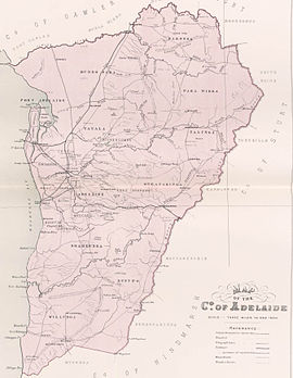
The County of Adelaide is one of the 49 cadastral counties of South Australia and contains the city of Adelaide.[2][4] It was proclaimed on 2 June 1842 by Governor Grey. It is bounded by the Gawler River and North Para River in the north, the Mount Lofty Ranges in the east, and Gulf St Vincent in the west. The south border runs from Aldinga Bay to Willunga South and Mount Magnificent.
| Adelaide South Australia | |||||||||||||||
|---|---|---|---|---|---|---|---|---|---|---|---|---|---|---|---|
 Map of Adelaide County in 1886 showing the hundreds | |||||||||||||||
| Established | 2 June 1842[1] | ||||||||||||||
| Area | 2,960 square kilometres (1,141 sq mi)[2] | ||||||||||||||
| |||||||||||||||
| Footnotes | Adjoining counties[3] | ||||||||||||||
The county held at least 60% of South Australia's population between 1855 and 1921; this figure rose to 70.6% in 1966.[5]
Hundreds
The county is divided into the following hundreds, from north west to south east:
- Hundred of Port Adelaide in the north west beside Gulf St Vincent between the Gawler River and Grand Junction Road
- Hundred of Barossa in the north spanning the Barossa Range
- Hundred of Munno Para in the north between the Gawler and Little Para rivers
- Hundred of Para Wirra in the north east immediately south of the South Para River
- Hundred of Yatala beside Gulf St Vincent between the Little Para and Torrens rivers
- Hundred of Talunga in the east, spanning the Torrens Valley in the Adelaide Hills
- Hundred of Adelaide in the west beside Gulf St Vincent and south of the Torrens River
- Hundred of Onkaparinga in the east spanning the Onkaparinga Valley in the Adelaide Hills
- Hundred of Noarlunga in the south west beside Gulf St Vincent between the Sturt and Onkaparinga rivers
- Hundred of Willunga in the south beside Gulf St Vincent and immediately south of the Onkaparinga
- Hundred of Kuitpo in the south east spanning the Adelaide Hills from the upper Onkaparinga and South Eastern Freeway to Mount Magnificent
See also
References
Wikiwand in your browser!
Seamless Wikipedia browsing. On steroids.
Every time you click a link to Wikipedia, Wiktionary or Wikiquote in your browser's search results, it will show the modern Wikiwand interface.
Wikiwand extension is a five stars, simple, with minimum permission required to keep your browsing private, safe and transparent.
