Αρχείο:Flores_map.png
From Wikipedia, the free encyclopedia
Δεν διατίθεται υψηλότερη ανάλυση.
Flores_map.png (300 × 122 εικονοστοιχεία, μέγεθος αρχείου: 21 KB, τύπος MIME: image/png)
|
|
Αυτό το αρχείο και η περιγραφή του προέρχονται από το Wikimedia Commons. Οι πληροφορίες από την σελίδα περιγραφής του εκεί εμφανίζονται παρακάτω. |

|
This locator map image could be re-created using vector graphics as an SVG file. This has several advantages; see Commons:Media for cleanup for more information. If an SVG form of this image is available, please upload it and afterwards replace this template with
{{vector version available|new image name}}.
It is recommended to name the SVG file “Flores map.svg”—then the template Vector version available (or Vva) does not need the new image name parameter. |
This image was copied from wikipedia:en. The original description was:
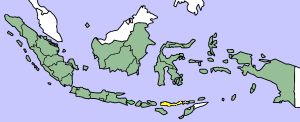
Map showing Flores Island within Indonesia
| Public domainPublic domainfalsefalse |
| Εγώ, ο κάτοχος των πνευματικών δικαιωμάτων αυτού του έργου, δημοσιεύω αυτό το έργο ως κοινό κτήμα. Αυτό ισχύει σε παγκόσμια κλίμακα. Σε ορισμένες χώρες αυτό μπορεί να μην είναι νομικά εφικτό. Αν ναι: Παραχωρώ σε οποιονδήποτε το δικαίωμα να χρησιμοποιήσει αυτό το έργο "για οποιονδήποτε σκοπό", χωρίς κανέναν όρο, εκτός και αν τέτοιοι όροι τίθενται από την νομοθεσία |
| date/time | username | edit summary |
|---|---|---|
| 14:17, 14 March 2005 | *drew | (Map showing Flores Island within Indonesia) |
Λεζάντες
Δεν ορίστηκε λεζάντα
Items portrayed in this file
απεικονίζει
Ιστορικό αρχείου
Κλικάρετε σε μια ημερομηνία/ώρα για να δείτε το αρχείο όπως εμφανιζόταν εκείνη τη στιγμή.
| Ώρα/Ημερομ. | Μικρογραφία | Διαστάσεις | Χρήστης | Σχόλια | |
|---|---|---|---|---|---|
| τελευταία | 10:19, 2 Φεβρουαρίου 2007 | 300 × 122 (21 KB) | J. Patrick Fischer | The original image was copied from wikipedia:en. The image was corrected by user:J. Patrick Fischer (two islands east of Flores were wrong marked as part of Flores before). The original description was: Map showing Flores Island within Indonesia {{ | |
| 12:26, 10 Οκτωβρίου 2006 | 300 × 122 (16 KB) | UtherSRG | Change color. | ||
| 12:27, 5 Οκτωβρίου 2005 | 300 × 122 (15 KB) | ChongDae | This image was copied from wikipedia:en. The original description was: Map showing Flores Island within Indonesia {{PD}} {| border="1" ! date/time || username || edit summary |---- | 14:17, 14 March 2005 || *drew || <nowiki>(Map showing Flores Island wi |
Συνδέσεις αρχείου
Τα παρακάτω λήμματα συνδέουν σε αυτό το αρχείο:
Καθολική χρήση αρχείου
Τα ακόλουθα άλλα wiki χρησιμοποιούν αυτό το αρχείο:
- Χρήση σε az.wikipedia.org
- Χρήση σε cy.wikipedia.org
- Χρήση σε en.wikipedia.org
- Χρήση σε en.wikivoyage.org
- Χρήση σε en.wiktionary.org
- Χρήση σε eo.wikipedia.org
- Χρήση σε fi.wikipedia.org
- Χρήση σε fr.wikipedia.org
- Χρήση σε gl.wikipedia.org
- Χρήση σε he.wikipedia.org
- Χρήση σε id.wikipedia.org
- Χρήση σε ilo.wikipedia.org
- Χρήση σε it.wikipedia.org
- Χρήση σε ko.wikipedia.org
- Χρήση σε min.wikipedia.org
- Χρήση σε ml.wikipedia.org
- Χρήση σε nl.wikipedia.org
- Χρήση σε nn.wikipedia.org
- Χρήση σε pt.wikipedia.org
- Χρήση σε tr.wikipedia.org
- Χρήση σε zh.wikipedia.org
Ανακτήθηκε από "https://el.wikipedia.org/wiki/Αρχείο:Flores_map.png"