Αρχείο:Colonisation_1885.png
From Wikipedia, the free encyclopedia
Εικόνα σε υψηλότερη ανάλυση (1.200 × 526 εικονοστοιχεία, μέγεθος αρχείου: 206 KB, τύπος MIME: image/png)
|
|
Αυτό το αρχείο και η περιγραφή του προέρχονται από το Wikimedia Commons. Οι πληροφορίες από την σελίδα περιγραφής του εκεί εμφανίζονται παρακάτω. |
| References for this description (or part of this) or for the depiction in the file are not provided. |
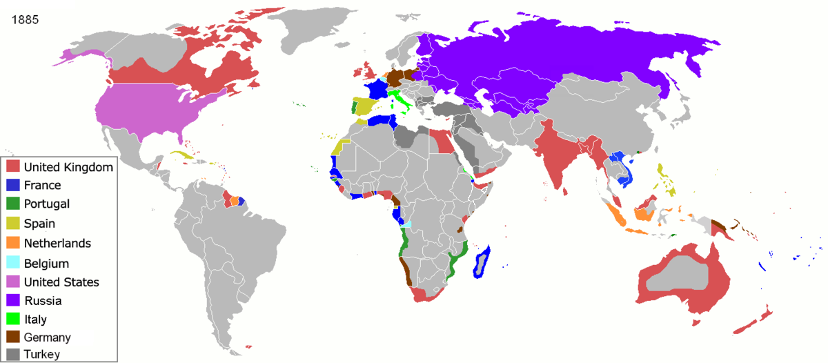
| ΠεριγραφήColonisation 1885.png |
Map of major world powers by year, derived from public domain animated map on wikipedia.
As the orriginal licence of the animation was Public Domain, this image which has been derived from it is too:
|
|||||||||||||||||||
| Ημερομηνία | ||||||||||||||||||||
| Πηγή | public domain animated map by ArdadN here | |||||||||||||||||||
| Δημιουργός | ArdadN | |||||||||||||||||||
.jpg)
._LOC_2001620596.jpg)

|
This historical map image could be re-created using vector graphics as an SVG file. This has several advantages; see Commons:Media for cleanup for more information. If an SVG form of this image is available, please upload it and afterwards replace this template with
{{vector version available|new image name}}.
It is recommended to name the SVG file “Colonisation 1885.svg”—then the template Vector version available (or Vva) does not need the new image name parameter. |
Λεζάντες
Items portrayed in this file
απεικονίζει
22 Μαρτίου 2007
image/png
checksum Αγγλικά
831fd10c262a996a3291205f48ebb3278f0cca4d
data size Αγγλικά
210.626 Byte
526 εικονοστοιχείο
1.200 εικονοστοιχείο
Ιστορικό αρχείου
Κλικάρετε σε μια ημερομηνία/ώρα για να δείτε το αρχείο όπως εμφανιζόταν εκείνη τη στιγμή.
| Ώρα/Ημερομ. | Μικρογραφία | Διαστάσεις | Χρήστης | Σχόλια | |
|---|---|---|---|---|---|
| τελευταία | 09:05, 8 Νοεμβρίου 2021 | | 1.200 × 526 (206 KB) | Randomastwritter | jubaland |
| 09:52, 5 Απριλίου 2020 |  | 1.200 × 526 (206 KB) | Ориенталист | South Sakhalin was part of Russia in 1885 | |
| 11:17, 2 Μαΐου 2015 |  | 1.425 × 625 (49 KB) | Chrischerf | German Empire and colonies in 1885; Sudan under control of the Mahdi | |
| 02:57, 3 Αυγούστου 2014 |  | 1.425 × 625 (54 KB) | Alvin Lee | correcting the boundaries of Russia and China | |
| 13:54, 3 Νοεμβρίου 2013 |  | 1.425 × 625 (78 KB) | McZusatz | Reverted to version as of 00:22, 24 January 2011 [corrupt file?] | |
| 15:24, 3 Νοεμβρίου 2012 |  | 1.425 × 625 (67 KB) | Franco310397 | Spanish presence in Micronesia (Oceania) included in the Captaincy General of the Philippines. In the Caroline Islands and the Mariana Islands. | |
| 00:22, 24 Ιανουαρίου 2011 |  | 1.425 × 625 (78 KB) | Micsha~commonswiki | Reverted to version as of 02:17, 3 May 2010 | |
| 00:22, 24 Ιανουαρίου 2011 |  | 506 × 326 (85 KB) | Micsha~commonswiki | Only Africa; includes map key | |
| 02:17, 3 Μαΐου 2010 |  | 1.425 × 625 (78 KB) | Kieran4 | slight edit | |
| 02:14, 3 Μαΐου 2010 |  | 1.425 × 625 (78 KB) | Kieran4 | Correct Dutch East INdies |
Συνδέσεις αρχείου
Δεν υπάρχουν σελίδες που συνδέουν σε αυτό το αρχείο.
Καθολική χρήση αρχείου
Τα ακόλουθα άλλα wiki χρησιμοποιούν αυτό το αρχείο:
- Χρήση σε am.wikipedia.org
- Χρήση σε de.wikipedia.org
- Χρήση σε en.wikipedia.org
- Χρήση σε es.wikipedia.org
- Χρήση σε fr.wikipedia.org
- Χρήση σε he.wikipedia.org
- Χρήση σε oc.wikipedia.org
- Χρήση σε sk.wikipedia.org
Μεταδεδομένα
Αυτό το αρχείο περιέχει πρόσθετες πληροφορίες, πιθανόν από την ψηφιακή φωτογραφική μηχανή ή το scanner που χρησιμοποιήθηκε για την δημιουργία ή την ψηφιοποίησή της. Αν το αρχείο έχει τροποποιηθεί από την αρχική του κατάσταση, ορισμένες λεπτομέρειες πιθανόν να μην αντιστοιχούν πλήρως στην τροποποιημένη εικόνα.
| Σχόλιο αρχείου PNG | |
|---|---|
| Οριζόντια ανάλυση | 47,24 dpc |
| Κατακόρυφη ανάλυση | 47,24 dpc |
| Λογισμικό που χρησιμοποιήθηκε |
|