File:Spread_of_Christianity_to_AD_600_(1).png
From Wikipedia, the free encyclopedia
Εικόνα σε υψηλότερη ανάλυση (2.187 × 1.619 εικονοστοιχεία, μέγεθος αρχείου: 227 KB, τύπος MIME: image/png)
|
|
Αυτό το αρχείο και η περιγραφή του προέρχονται από το Wikimedia Commons. Οι πληροφορίες από την σελίδα περιγραφής του εκεί εμφανίζονται παρακάτω. |
Σύνοψη
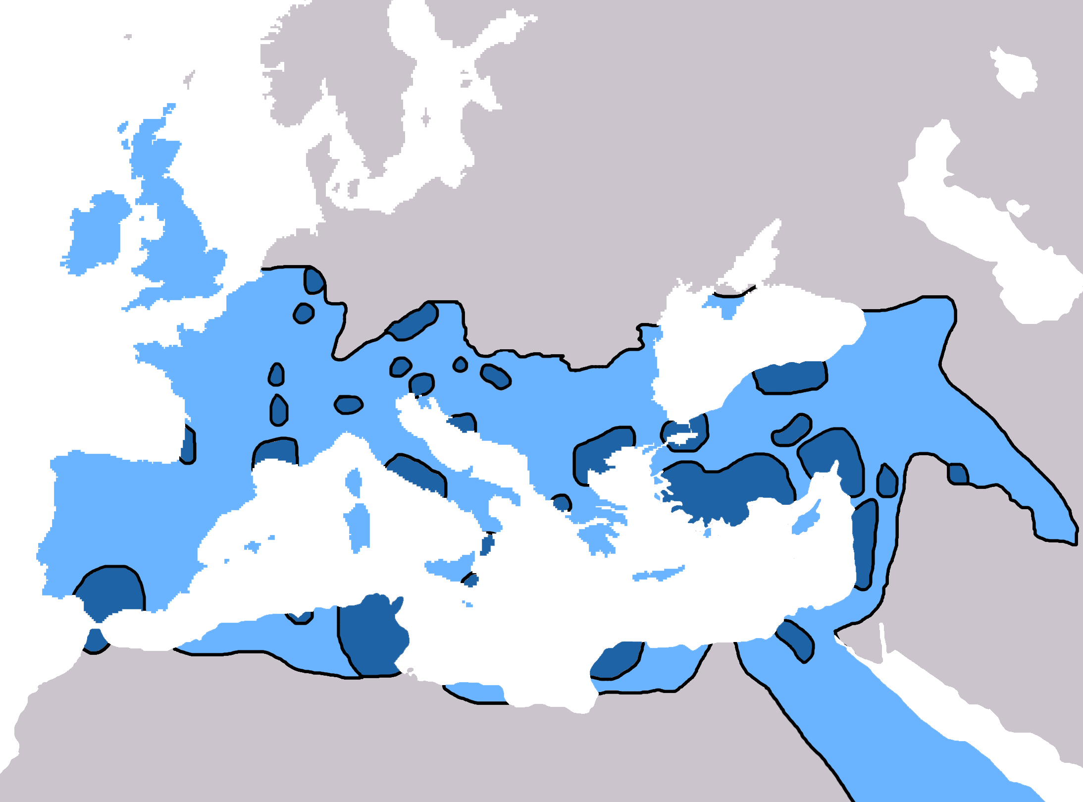
| ΠεριγραφήSpread of Christianity to AD 600 - Atlas of World History.png |
English: Map of the spread of Christianity in Europe, Southwest Asia and North Africa to the year AD 600.
"redominantly Christian by AD 325" zone coloured in dark blue, "Predominantly Christian by AD 600" coloured in light blue.
Magyar: A kereszténység elterjedése:
Information obtained from Patrick O'Brien , ed. (2003) Atlas of World History, Category:New York: Oxford University Press, pp. 44−5 0-19-521921-X Map created and uploaded in the English Wikipedia by Geuiwogbil. Base map: "File:BlankMap-Europe-v3.png" |
| Ημερομηνία | 27 Μαΐου 2009 (original upload date) |
| Πηγή | Transferred from en.wikipedia to Commons by QuartierLatin1968 using CommonsHelper. |
| Δημιουργός | Geuiwogbil at Αγγλικά Βικιπαίδεια |

|
This religion map image could be re-created using vector graphics as an SVG file. This has several advantages; see Commons:Media for cleanup for more information. If an SVG form of this image is available, please upload it and afterwards replace this template with
{{vector version available|new image name}}.
It is recommended to name the SVG file “Spread of Christianity to AD 600 - Atlas of World History.svg”—then the template Vector version available (or Vva) does not need the new image name parameter. |
Αδειοδότηση
| Το αρχείο διανέμεται υπό την άδεια Creative Commons Αναφορά προέλευσης-Παρόμοια διανομή 3.0 Μη εισαγόμενη Με τους όρους των αποποίηση ευθυνών. | ||
| Απόδοση: Geuiwogbil from en.wikipedia.org | ||
| ||
| Αυτή η ετικέτα άδειας χρήσης προστέθηκε στο αρχείο ως μέρους της αναθεώρησης της άδειας GFDL .http://creativecommons.org/licenses/by-sa/3.0/CC BY-SA 3.0Creative Commons Attribution-Share Alike 3.0truetrue |

|
Παραχωρείται η άδεια προς αντιγραφή, διανομή και/ή τροποποίηση αυτού του εγγράφου υπό τους όρους της Άδειας Ελεύθερης Τεκμηρίωσης GNU, Έκδοση 1.2 ή οποιασδήποτε νεότερης έκδοσης δημοσιευμένης από το Ίδρυμα Ελεύθερου Λογισμικού· χωρίς Απαράλαχτους Τομείς, χωρίς Κείμενα Εξωφύλλου, και χωρίς Κείμενα Οπισθοφύλλου. Αντίγραφο της άδειας περιλαμβάνεται στην σελίδα με τίτλο GNU Free Documentation License. Με τους όρους των αποποίηση ευθυνών.http://www.gnu.org/copyleft/fdl.htmlGFDLGNU Free Documentation Licensetruetrue |
Καταγραφές ανεβασμάτων πρωτότυπου αρχείου
- 2009-05-27 19:20 Carlaude 2187×1619× (232587 bytes) Cutting out unused areas of the map
- 2006-09-09 02:34 Geuiwogbil 2285×2181× (248280 bytes) Blue provides us with a better constrast.
- 2006-09-04 05:10 Geuiwogbil 2285×2181× (254524 bytes)
- 2006-09-04 05:08 Geuiwogbil 2285×2181× (116034 bytes) Map of the spread of Christianity in Europe, Southwest Asia and North Africa to the year 600 AD. Base map "BlankMap-Europe-v.3." Spread of Christianity to AD 325 coloured in orange, to 600 coloured in yellow. Information obtained from {{cite book |editor=
Λεζάντες
Items portrayed in this file
απεικονίζει
27 Μαΐου 2009
image/png
Ιστορικό αρχείου
Κλικάρετε σε μια ημερομηνία/ώρα για να δείτε το αρχείο όπως εμφανιζόταν εκείνη τη στιγμή.
| Ώρα/Ημερομ. | Μικρογραφία | Διαστάσεις | Χρήστης | Σχόλια | |
|---|---|---|---|---|---|
| τελευταία | 17:31, 3 Ιουνίου 2022 | | 2.187 × 1.619 (227 KB) | Veverve | Reverted to version as of 10:19, 4 July 2021 (UTC) please bring a map source to counter this claim that only part of Armenia etc. were partially christianised |
| 17:08, 3 Ιουνίου 2022 |  | 2.187 × 1.619 (245 KB) | Rs4815 | Reverted to version as of 09:58, 24 February 2013 (UTC) You can't just ignore the fact that the "sourced version of the map" has a blunder. By the year 325, the Armenian kingdom had already been converted to Christianity | |
| 10:19, 4 Ιουλίου 2021 |  | 2.187 × 1.619 (227 KB) | Veverve | Reverted to version as of 12:31, 9 November 2009 (UTC) revert to what is an actually sourced version of the map | |
| 06:34, 23 Μαΐου 2018 |  | 2.187 × 1.619 (213 KB) | Inowen | Add labels for Europe, Africa, and Middle East using Inkscape to import previous and overlay text in svg. | |
| 09:58, 24 Φεβρουαρίου 2013 |  | 2.187 × 1.619 (245 KB) | Prince of Nothing05 | Kingdom of Armenia, Iberia and Caucasian Albania had already made Christianity official religion. | |
| 12:31, 9 Νοεμβρίου 2009 |  | 2.187 × 1.619 (227 KB) | QuartierLatin1968 | {{Information |Description={{en|Map of the spread of Christianity in Europe, Southwest Asia and North Africa to the year 600 AD. Base map "BlankMap-Europe-v.3." Spread of Christianity to AD 325 coloured in light blue, to 600 coloured in dark blue. Informa |
Συνδέσεις αρχείου
Τα παρακάτω λήμματα συνδέουν σε αυτό το αρχείο:
Καθολική χρήση αρχείου
Τα ακόλουθα άλλα wiki χρησιμοποιούν αυτό το αρχείο:
- Χρήση σε ar.wikipedia.org
- Χρήση σε arz.wikipedia.org
- Χρήση σε be.wikipedia.org
- Χρήση σε bg.wikipedia.org
- Χρήση σε ca.wikipedia.org
- Χρήση σε cs.wikipedia.org
- Χρήση σε de.wikipedia.org
- Χρήση σε en.wikipedia.org
- Christendom
- Christian Church
- Christianity in Africa
- Talk:Christian Church/Archive 1
- Christianity in the Middle East
- Spread of Christianity
- Multiculturalism and Christianity
- Western world
- Christianity in the ante-Nicene period
- Christianity in the 4th century
- Christianity in the 5th century
- Christianity in the 6th century
- Christianity in the 7th century
- Christianity in late antiquity
- Christianity as the Roman state religion
- Roman people
- User:Falcaorib/Medieval Empires (500-650 AD)
- User:Falcaorib/Europe
- Χρήση σε en.wikibooks.org
- Χρήση σε en.wikiquote.org
- Χρήση σε eo.wikipedia.org
- Χρήση σε es.wikipedia.org
Δείτε περισσότερη καθολική χρήση αυτού του αρχείου.
Μεταδεδομένα
Αυτό το αρχείο περιέχει πρόσθετες πληροφορίες, πιθανόν από την ψηφιακή φωτογραφική μηχανή ή το scanner που χρησιμοποιήθηκε για την δημιουργία ή την ψηφιοποίησή της. Αν το αρχείο έχει τροποποιηθεί από την αρχική του κατάσταση, ορισμένες λεπτομέρειες πιθανόν να μην αντιστοιχούν πλήρως στην τροποποιημένη εικόνα.
| Οριζόντια ανάλυση | 28,34 dpc |
|---|---|
| Κατακόρυφη ανάλυση | 28,34 dpc |