File:Czechoslovakia01.png
From Wikipedia, the free encyclopedia
Εικόνα σε υψηλότερη ανάλυση (1.100 × 468 εικονοστοιχεία, μέγεθος αρχείου: 63 KB, τύπος MIME: image/png)
| Αυτό το αρχείο και η περιγραφή του προέρχονται από το Wikimedia Commons. Οι πληροφορίες από την σελίδα περιγραφής του εκεί εμφανίζονται παρακάτω. |
Σύνοψη
| ΠεριγραφήCzechoslovakia01.png |
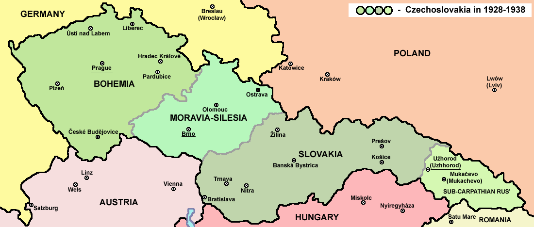
English: Map of Czechoslovakia in 1928-1938. Note: The provinces shown on the map were introduced by Act No. 125/1927 Zb. and became effective in 1928. Deutsch: Karte der Tschechoslowakei zwischen 1928 und 1938. |
|||
| Ημερομηνία | ||||
| Πηγή |
Έργο αυτού που το ανεβάζει Main reference:
Secondary references with similar maps:
Secondary references about Geo-political situation - published sources:
Secondary reference about sizable cities: |
|||
| Δημιουργός |
PANONIAN
|
|||
| Άδεια (Επαναχρησιμοποίηση αυτού του αρχείου) |
|
|||
| άλλες εκδόσεις |
Derivative works of this file: |


|
This map image could be re-created using vector graphics as an SVG file. This has several advantages; see Commons:Media for cleanup for more information. If an SVG form of this image is available, please upload it and afterwards replace this template with
{{vector version available|new image name}}.
It is recommended to name the SVG file “Czechoslovakia01.svg”—then the template Vector version available (or Vva) does not need the new image name parameter. |
The production, editing or release of this file was supported by the Community-Budget of Wikimedia Deutschland. To see other files made with the support of Wikimedia Deutschland, please see the category Supported by Wikimedia Deutschland. العربية ∙ বাংলা ∙ Deutsch ∙ English ∙ Esperanto ∙ français ∙ magyar ∙ Bahasa Indonesia ∙ italiano ∙ 日本語 ∙ македонски ∙ മലയാളം ∙ Bahasa Melayu ∙ Nederlands ∙ português ∙ русский ∙ slovenščina ∙ svenska ∙ українська ∙ தமிழ் ∙ +/−
|
Λεζάντες
Items portrayed in this file
απεικονίζει
image/png
checksum Αγγλικά
bd003d1960e9404724758c8fa7f85ee852d01738
data size Αγγλικά
64.020 Byte
468 εικονοστοιχείο
1.100 εικονοστοιχείο
Ιστορικό αρχείου
Κλικάρετε σε μια ημερομηνία/ώρα για να δείτε το αρχείο όπως εμφανιζόταν εκείνη τη στιγμή.
| Ώρα/Ημερομ. | Μικρογραφία | Διαστάσεις | Χρήστης | Σχόλια | |
|---|---|---|---|---|---|
| τελευταία | 14:48, 12 Ιουλίου 2022 | | 1.100 × 468 (63 KB) | Sebastian Wallroth | cropped |
| 10:54, 19 Μαΐου 2011 |  | 1.128 × 513 (63 KB) | PANONIAN | minor change, marked provincial capitals | |
| 09:53, 17 Μαΐου 2011 |  | 1.128 × 513 (62 KB) | PANONIAN | Reverted to version as of 10:38, 24 April 2011 - because this is map of Czechoslovakia and it was capital of Czechoslovakia | |
| 05:07, 17 Μαΐου 2011 |  | 1.128 × 513 (55 KB) | Millenium187 | Why was Prague underlined and Vienna, Brno, Bratislava and other capital cities were not? -- corrected | |
| 10:38, 24 Απριλίου 2011 |  | 1.128 × 513 (62 KB) | PANONIAN | few corrections | |
| 11:31, 23 Απριλίου 2011 |  | 1.128 × 509 (61 KB) | PANONIAN | improved version | |
| 20:58, 20 Δεκεμβρίου 2008 |  | 1.100 × 497 (78 KB) | Kirk979 | {{Information |Description= |Source= |Date= |Author= |Permission= |other_versions= }} | |
| 16:11, 28 Δεκεμβρίου 2006 |  | 1.100 × 497 (90 KB) | Electionworld | {{ew|en|PANONIAN}} Map of {{link|Czechoslovakia}} (self made) Note: The provinces shown on the map were introduced by Act No. 125/1927 Zb. and became effective in 1928. {{PD-self}} Category:Maps of Czechoslovakia Category:Maps of Czech history |
Συνδέσεις αρχείου
Τα παρακάτω λήμματα συνδέουν σε αυτό το αρχείο:
Καθολική χρήση αρχείου
Τα ακόλουθα άλλα wiki χρησιμοποιούν αυτό το αρχείο:
- Χρήση σε af.wikipedia.org
- Χρήση σε als.wikipedia.org
- Χρήση σε ang.wikipedia.org
- Χρήση σε an.wikipedia.org
- Χρήση σε ar.wikipedia.org
- Χρήση σε arz.wikipedia.org
- Χρήση σε azb.wikipedia.org
- Χρήση σε az.wikipedia.org
- Χρήση σε bar.wikipedia.org
- Χρήση σε ba.wikipedia.org
- Χρήση σε bcl.wikipedia.org
- Χρήση σε be-tarask.wikipedia.org
- Χρήση σε be.wikipedia.org
- Χρήση σε bg.wikipedia.org
- Χρήση σε bn.wikipedia.org
- Χρήση σε br.wikipedia.org
- Χρήση σε ca.wikipedia.org
- Χρήση σε cs.wikipedia.org
- Χρήση σε cv.wikipedia.org
- Χρήση σε cy.wikipedia.org
- Χρήση σε de.wikipedia.org
- Χρήση σε diq.wikipedia.org
- Χρήση σε dsb.wikipedia.org
- Χρήση σε en.wikipedia.org
Δείτε περισσότερη καθολική χρήση αυτού του αρχείου.
Μεταδεδομένα
Αυτό το αρχείο περιέχει πρόσθετες πληροφορίες, πιθανόν από την ψηφιακή φωτογραφική μηχανή ή το scanner που χρησιμοποιήθηκε για την δημιουργία ή την ψηφιοποίησή της. Αν το αρχείο έχει τροποποιηθεί από την αρχική του κατάσταση, ορισμένες λεπτομέρειες πιθανόν να μην αντιστοιχούν πλήρως στην τροποποιημένη εικόνα.
| Οριζόντια ανάλυση | 28,35 dpc |
|---|---|
| Κατακόρυφη ανάλυση | 28,35 dpc |