ފައިލު:Outre-mer_en_sans_Terre_Adelie.png
From Wikipedia, the free encyclopedia
Size of this preview: 800 × 342 pixels. Other resolutions: 320 × 137 pixels | 640 × 273 pixels | 1,456 × 622 pixels.
Original file (1,456 × 622 pixels, file size: 49 KB, MIME type: image/png)
މި ފައިލަކީ Wikimedia Commonsގެ ފައިލެކެވެ. އަދި އެހެން މަޝްރޫޢުތަކުގައި ބޭނުން ކުރެވިފައި ހުރެދާނެއެވެ. މި ފައިލުގެ ތަފްސީލް ފައިލު ތަފްސީލް ޞަފްޙާއިން ތިރީގައިވަނީއެވެ.
ހުލާސާ

|
This locator map image could be re-created using vector graphics as an SVG file. This has several advantages; see Commons:Media for cleanup for more information. If an SVG form of this image is available, please upload it and afterwards replace this template with
{{vector version available|new image name}}.
It is recommended to name the SVG file “Outre-mer en sans Terre Adelie.svg”—then the template Vector version available (or Vva) does not need the new image name parameter. |
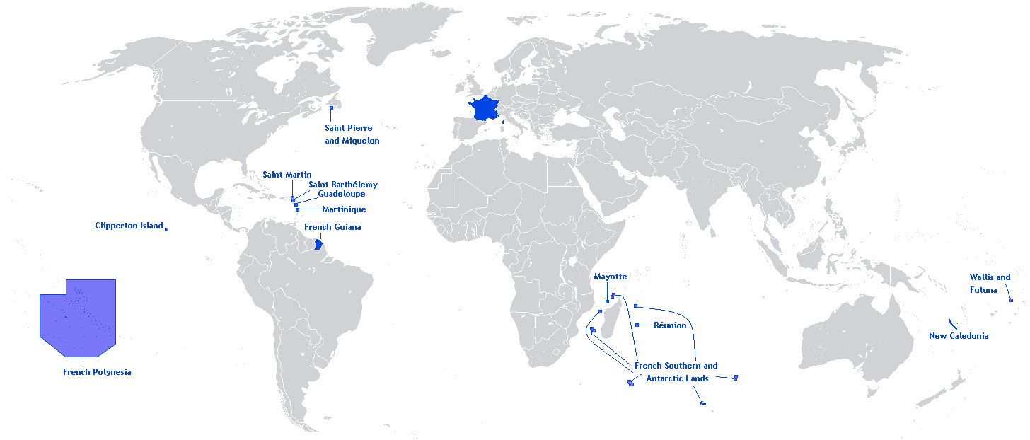
| DescriptionOutre-mer en sans Terre Adelie.png |
English: A map showing the Overseas departments and territories of France, excluding the territory of Adélie Land in Antarctica, where sovereignty is suspended |
| ތާރީހް | |
| މަސްދަރު | Own work |
| Author | Originally Hoshie |
| Other versions | Adapted from File:Outre-mer en.png |
English: This image is a cropped version of Image:Outre-mer en.png initally created by user Hoshie. Antarctica was cropped.
Licensing
Hoshie, the copyright holder of this work, hereby publishes it under the following license:

|
Permission is granted to copy, distribute and/or modify this document under the terms of the GNU Free Documentation License, Version 1.2 or any later version published by the Free Software Foundation; with no Invariant Sections, no Front-Cover Texts, and no Back-Cover Texts. A copy of the license is included in the section entitled GNU Free Documentation License.http://www.gnu.org/copyleft/fdl.htmlGFDLGNU Free Documentation Licensetruetrue |
| This file is licensed under the Creative Commons Attribution-Share Alike 3.0 Unported license. | ||
| Attribution: Hoshie | ||
| ||
| This licensing tag was added to this file as part of the GFDL licensing update.http://creativecommons.org/licenses/by-sa/3.0/CC BY-SA 3.0Creative Commons Attribution-Share Alike 3.0truetrue |
Captions
Add a one-line explanation of what this file represents
Items portrayed in this file
depicts English
copyright status English
copyrighted English
inception English
27 މެއި 2012
source of file English
original creation by uploader English
ޞަފްޙާގެ ތާރީޚް
Click on a date/time to view the file as it appeared at that time.
| ތާރީޚް/ގަޑި | ތަމްބްނެއިލް | Dimensions | މެމްބަރު | ޚިޔާލު | |
|---|---|---|---|---|---|
| މިހާރު | 01:26, 28 މާރޗް 2018 | | 1,456 × 622 (49 KB) | Maphobbyist | Upload |
| 17:01, 27 މެއި 2012 |  | 1,456 × 622 (59 KB) | Hazhk | Changing color | |
| 01:47, 13 ފެބްރުއަރީ 2012 |  | 1,480 × 625 (68 KB) | Spesh531 | same as File:Outre-mer en.png, without Antarctica | |
| 05:35, 21 އޮކްޓޫބަރު 2010 |  | 1,431 × 655 (54 KB) | Rosss | Better view of French Polynesia | |
| 02:23, 26 ނޮވެމްބަރު 2009 |  | 1,431 × 655 (30 KB) | The Illusional Ministry | removed borer from french polynesia | |
| 02:22, 26 ނޮވެމްބަރު 2009 |  | 1,431 × 655 (30 KB) | The Illusional Ministry | ||
| 08:31, 17 ޑިސެމްބަރު 2007 |  | 1,431 × 655 (35 KB) | Rosss | Wider margin | |
| 08:26, 17 ޑިސެމްބަރު 2007 |  | 1,431 × 639 (35 KB) | Rosss | This image is a cropped version of Image:Outre-mer en.png initally created by user Hoshie. Antartica was cropped. ==License== {{GFDL-user|Hoshie}} Category:World maps of Overseas France |
ފާލަންތައް
The following page uses this file:
Global file usage
The following other wikis use this file:
- Usage on an.wikipedia.org
- Usage on awa.wikipedia.org
- Usage on bn.wikibooks.org
- Usage on ckb.wikipedia.org
- Usage on da.wikipedia.org
- Usage on en.wikipedia.org
- Regions of France
- Outline of France
- Wikipedia:Graphics Lab/Map workshop/Archive/Dec 2009
- Wikipedia:Graphics Lab/Map workshop/Archive/Jun 2012
- User:SkulkingMEDIA
- User:Andreapr94/sandbox/Infobox/Country
- User:Jonperez91/sandbox/Infoboxes/Country
- User:Ane San José/sandbox/Infobox/Country
- User:P.aurrecoechea/Sandbox/Infobox/Country
- User:Trizia9/sandbox/Infobox/Country
- User:Ibonarzua/sandbox/Infobox/Country
- User:Mikel M/sandbox/Infobox/Country
- Usage on en.wikibooks.org
- Usage on es.wikipedia.org
- Usage on et.wikipedia.org
- Usage on eu.wikipedia.org
- Usage on fa.wikipedia.org
- Usage on fr.wikipedia.org
- Usage on hi.wikipedia.org
- Usage on hy.wikipedia.org
- Usage on id.wikipedia.org
- Usage on id.wikibooks.org
- Usage on ilo.wikipedia.org
- Usage on ja.wikipedia.org
- Usage on lv.wikipedia.org
- Usage on mai.wikipedia.org
- Usage on min.wikipedia.org
- Usage on ml.wikipedia.org
- Usage on mzn.wikipedia.org
- Usage on ne.wikipedia.org
- Usage on nl.wikipedia.org
- Usage on no.wikipedia.org
- Usage on pa.wikipedia.org
- Usage on pcd.wikipedia.org
- Usage on pdc.wikipedia.org
- Usage on pt.wikipedia.org
- Usage on sah.wikipedia.org
- Usage on sh.wikipedia.org
- Usage on sr.wikinews.org
View more global usage of this file.
މެޓަޑޭޓާ
This file contains additional information, probably added from the digital camera or scanner used to create or digitize it.
If the file has been modified from its original state, some details may not fully reflect the modified file.
| Horizontal resolution | 37.8 dpc |
|---|---|
| Vertical resolution | 37.8 dpc |