Dosya:Sivas_districts.png
From Wikipedia, the free encyclopedia
Vervênayışê ebadê: 776 × 600 piksel. Agoznayışê bini: 311 × 240 piksel | 621 × 480 piksel | 994 × 768 piksel | 1,056 × 816 piksel.
Ebato oricinale (1,056 × 816 pikselan, ebatê dosya: 35 KB, MIME tipê cı: image/png)
| Na dosya depoyê Wikimedia Commons de esta u terefê proceyanê binan ra gureniyena. Cêr dê şınasiya dosyay pela mocniyeno. |
Xulasa
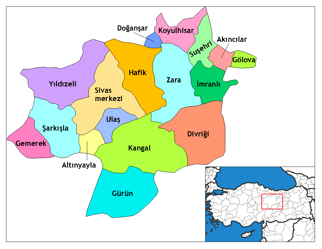
| ŞınasnayışSivas districts.png | Map of the districts of Sivas province in Turkey. Created by Rarelibra 17:51, 4 December 2006 (UTC) for public domain use, using MapInfo Professional v8.5 and various mapping resources. Edited by One Homo Sapiens Corrected text where İ,Ş,ı,ğ,or ş occurs in name. Source: [statoids-com]. Increased font size and enhanced color differences among adjacent districts. |
| Tarix | 4 Kanun 2006 (original upload date) |
| Çıme | No machine-readable source provided. Own work assumed (based on copyright claims). |
| Nuştekar | No machine-readable author provided. Rarelibra assumed (based on copyright claims). |

|
This locator map image could be re-created using vector graphics as an SVG file. This has several advantages; see Commons:Media for cleanup for more information. If an SVG form of this image is available, please upload it and afterwards replace this template with
{{vector version available|new image name}}.
It is recommended to name the SVG file “Sivas districts.svg”—then the template Vector version available (or Vva) does not need the new image name parameter. |
Lisans
| Public domainPublic domainfalsefalse |
| Ez, Wêrê ena teliferê, nê kari Malê şarideye ezo heserena. Dınya heme ca dı ravêreno. Tay dewletan dı no kanuniyey heta mıkum nêbone; o haldı: Ez, ena karer qande herhangi yew amaci, be şert, hendı ke legali icab nikeni, şari hemi re ezo mısade dana. |
Captions
Add a one-line explanation of what this file represents
Districts of Sivas
Sivas haritası
Items portrayed in this file
Dewrê mocnayışi
4 Kanun 2006
Verêniya dosya
Seba diyayışê viyarteyê dosya ra tarixê ke qısımê tarix/zemani derê inan bıtıkne.
| Tarix/Zeman | Resımo qıckek | Ebadi | Karber | Mışewre | |
|---|---|---|---|---|---|
| nıkayên | 02:09, 29 Kanun 2008 | | 1,056 - 816 (35 KB) | One Homo Sapiens | Corrected text where İ,Ş,ı,ğ,or ş occurs in name. Source: [statoids-com]. Increased font size and enhanced color differences among adjacent districts. |
| 17:51, 4 Kanun 2006 |  | 1,056 - 816 (37 KB) | Rarelibra | Map of the districts of Sivas province in Turkey. Created by ~~~~ for public domain use, using MapInfo Professional v8.5 and various mapping resources. |
Gurenayışê dosya
100 ra zêde peli na dosya gurenenê. Ena lista cêrêne dosyeyanê 100 sıfteyınanê ke tenya na dosya gurenenê, inan mocnena. Yew lista pêro mevcuda.
- Abdaloğliye
- Ademfeqiye
- Afşar
- Akdere
- Akpınar
- Andriyas
- Aqwêran
- Armağan
- Arpaliye
- Awşarwêran
- Ağcaqaş
- Ağvanis
- Babso
- Bağlame
- Bedrosi
- Beyyurdu
- Bozarmut
- Bırhaniya
- Cancin
- Cemku
- Davulbaz
- Dayiliye
- Deligazi
- Deliktaş, Qanğal
- Delioğlanderesi
- Depexan
- Deredamiye
- Derêsali
- Dewa Deri
- Dewa Deriye
- Dêwrığe
- Ezbider
- Gemerek
- Gewher
- Gürün
- Hamal
- Haptsey
- Havuz
- Hedku
- Höyüklüyurt
- Irmaç
- Karanlık
- Kemerız
- Khela
- Kiroyan
- Komsorık
- Koroğlan
- Koğulkoyiye
- Kurêeyşa
- Kuşkayası
- Kürkçü
- Kırkpınar, Qanğal
- Mancılık
- Mezgit
- Mıhurqulaq
- Mısırwêran
- Mışaz
- Paknig
- Qablan
- Qanğal
- Qeregucige
- Qewaxe
- Qezê Tırkiya
- Qırnaqoc
- Qızıldikme
- Qızıleniş
- Samud Tekke
- Sarıpınar
- Sultanpar
- Sêwaz
- Sêwaz (wılayet)
- Sıçanhoyıge
- Tahtaliye
- Tersekan
- Todırge
- Tonus
- Topardic
- Ulaş
- Umraniya
- Urumlu
- Xocaqurt
- Yarhisar
- Yellice
- Yenikoyiye, Qanğal
- Yenixan
- Yortan
- Yukarıhoyıge
- Zera
- Zerık
- Zımage (Umraniya)
- Zımmiyan
- Çamoziya Corêne
- Çamoziya Cêrêne
- Çet, Qanğal
- Çiftlikwêran
- İmamdamiye
- İpsile
- Şahkulan
- Şeherqışle
- Şekerpınar
Tayêna gıreyanê na pele bıvênên.
Gurenayışê dosyaya gılovere
Ena dosya wikiyanê binan de gureniyena.
- ar.wikipedia.org sero guriyayış
- arz.wikipedia.org sero guriyayış
- ast.wikipedia.org sero guriyayış
- azb.wikipedia.org sero guriyayış
- ca.wikipedia.org sero guriyayış
- cs.wikipedia.org sero guriyayış
- de.wikipedia.org sero guriyayış
- en.wikipedia.org sero guriyayış
- Sivas Province
- User talk:Rarelibra/Maps4
- Districts of Turkey
- Governor of Sivas
- List of populated places in Sivas Province
- Sivas University of Science and Technology
- Altınyayla District, Sivas
- Zara District
- Akıncılar District
- Divriği District
- Doğanşar District
- Gölova District
- Gürün District
- Hafik District
- İmranlı District
- Kangal District
- Koyulhisar District
- Suşehri District
- Ulaş District
- Gemerek District
- Şarkışla District
- Sivas District
- Yıldızeli District
- en.wiktionary.org sero guriyayış
Yê na dosya gurenayışê gıloveri tayêna bıvêne.
Metadata
This file contains additional information, probably added from the digital camera or scanner used to create or digitize it. If the file has been modified from its original state, some details may not fully reflect the modified image.
| Qerarê verıniye | 37.8 dpc |
|---|---|
| Rezulasyanê derganiye | 37.8 dpc |
Retrieved from "https://diq.wikipedia.org/wiki/Dosya:Sivas_districts.png"