Dosya:Isabella's_invasion_route_(1326).png
From Wikipedia, the free encyclopedia
Isabella's_invasion_route_(1326).png (628 × 316 pikselan, ebatê dosya: 94 KB, MIME tipê cı: image/png)
| Na dosya depoyê Wikimedia Commons de esta u terefê proceyanê binan ra gureniyena. Cêr dê şınasiya dosyay pela mocniyeno. |
| ŞınasnayışIsabella's invasion route (1326).png |
Deutsch: Positionskarte von England Quadratische Plattkarte, N-S-Streckung 170 %. Geographische Begrenzung der Karte: * N: 56.0° N * S: 49.75° N * W: 6.75° W * O: 2.0° O English: Location map of England Equirectangular projection, N/S stretching 170 %. Geographic limits of the map: * N: 56.0° N * S: 49.75° N * W: 6.75° W * E: 2.0° E |
| Tarix | (UTC) |
| Çıme |
|
| Nuştekar |
|
| Versiyonane binan | Derivative works of this file: Isabella's invasion route 1326 (ru).svg |
.svg)
| no fotraf rotuşin biyo, fotrafi sero hebe ki vırnayış biyo. vırnayışi zi: Isabella of France's invasion route in 1326 added..orcinal fotrafo tiya de yo: England location map.svg. fotrafdı sazbiyayış zi Hch2009 kerdo.
|
- Nê weçenegan dê xoseri:
- bare kerdene – qe gure kopya kerdişi, vila kerdişi u şawitişi
- qe reyna mix kerdişi – qe kabul kerdişi gure
- bine enê şarti:
- gıredayış – Lazımo ke şıma icazet bıdê, lisansi rê link, vuriyayış ke biyo belû kerê. Ney şıma usulên ra şenê bıkerê, labelê karkerdış u iştirakê şıma terefê wayirê lisansi ra zey qebulbiyene yew qeyde çıniyo.
- sey yewbini barekerdış – Meqaleyi ke reyna têv dê, tadê ya zi fına inşa bıkerê, iştırakê şıma lazımo ke zey orcinali same or compatible license bın de vıla kerê.
Qeydê barkerdışê oricinali
This image is a derivative work of the following images:
- File:England_location_map.svg licensed with Cc-by-sa-3.0
- 2010-03-12T22:58:19Z Spischot 816x991 (468569 Bytes) •••••••••••••••••••••••••••••••••••••••••••••••••••••••••••••••••••••••••••••••••••••••••••••••••••••••••••••••••••••••••••••••••••••••••••••••••••••••••••••••••••••••••••••••••••••••••••••••••••••••••••••••••••••••••••••••••
Uploaded with derivativeFX
| Annotations InfoField | This image is annotated: View the annotations at Commons |
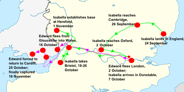
This uses the data set of Isabella and Mortimer's travels from Weir's "Isabella: She Wolf of France" and Mortimer's "The Greatest Traitor", combined with Myer's "England in the Late Middle Ages" details on medieval roads and trade routes.
Captions
Items portrayed in this file
Dewrê mocnayışi
copyrighted English
15 Nisane 2010
Verêniya dosya
Seba diyayışê viyarteyê dosya ra tarixê ke qısımê tarix/zemani derê inan bıtıkne.
| Tarix/Zeman | Resımo qıckek | Ebadi | Karber | Mışewre | |
|---|---|---|---|---|---|
| nıkayên | 21:08, 5 Temuze 2018 | | 628 - 316 (94 KB) | John | Fixed date formats |
| 06:41, 15 Nisane 2010 |  | 628 - 316 (81 KB) | Hchc2009 | {{Information |Description={{de|Positionskarte von England}} Quadratische Plattkarte, N-S-Streckung 170 %. Geographische Begrenzung der Karte: * N: 56.0° N * S: 49.75° N * W: 6.75° W * O: 2.0° O {{en|Location map of [[:en:England|En |
Gurenayışê dosya
There are no pages that link to this file.
Gurenayışê dosyaya gılovere
Ena dosya wikiyanê binan de gureniyena.
- da.wikipedia.org sero guriyayış
- id.wikipedia.org sero guriyayış
- no.wikipedia.org sero guriyayış
Metadata
This file contains additional information, probably added from the digital camera or scanner used to create or digitize it. If the file has been modified from its original state, some details may not fully reflect the modified image.
| Karenaye nusnerek | Adobe Photoshop CC 2018 (Windows) |
|---|---|
| Demê dijitalkerdışi | 22:56, 5 Temuze 2018 |
| File change date and time | 23:06, 5 Temuze 2018 |
| Malumatê metamalumati peyd timarya | 23:06, 5 Temuze 2018 |
| Xasiya ID ya dokuman de orcinali | xmp.did:4da2c9be-6471-c94e-afe1-00a817196faf |
| Qerarê verıniye | 35.43 dpc |
| Rezulasyanê derganiye | 35.43 dpc |
.png)