Loading AI tools
Mártély ist eine ungarische Gemeinde im Kreis Hódmezővásárhely im Komitat Csongrád-Csanád. Sie liegt an einem toten Arm der Theiß. Mártély hat 1301 Einwohner (Stand 2015).
| Mártély | |||||
| |||||
| Basisdaten | |||||
|---|---|---|---|---|---|
| Staat: | |||||
| Region: | Südliche Große Tiefebene | ||||
| Komitat: | Csongrád-Csanád | ||||
| Kleingebiet bis 31.12.2012: | Hódmezővásárhely | ||||
| Kreis: | Hódmezővásárhely | ||||
| Koordinaten: | 46° 28′ N, 20° 14′ O | ||||
| Fläche: | 36,45 km² | ||||
| Einwohner: | 1.296 (1. Jan. 2022) | ||||
| Bevölkerungsdichte: | 36 Einwohner je km² | ||||
| Telefonvorwahl: | (+36) 62 | ||||
| Postleitzahl: | 6636 | ||||
| KSH-kód: | 25733 | ||||
| Struktur und Verwaltung (Stand: 2020) | |||||
| Gemeindeart: | Gemeinde | ||||
| Bürgermeisterin: | Anita Putz[1] (parteilos) | ||||
| Postanschrift: | Rákóczi tér 1 6636 Mártély | ||||
| Website: | |||||
| (Quelle: Localities 01.01.2022. bei Központi statisztikai hivatal) | |||||


 Verbandsgemeinde Altenahr, Deutschland
 Detk, Ungarn
 Eremitu, Rumänien
 Trešnjevac (Трешњевац), Serbien
- Landschaftsschutzgebiet an der Theiß
- Römisch-katholische Kirche Szent Adorján, erbaut 1910–1911
- Windmühle (Késmárki Imre-féle szélmalom)
Durch Mártély verläuft die Landstraße Nr. 4521. Die Gemeinde ist angebunden an die Eisenbahnstrecke von Szentes nach Hódmezővásárhely.
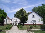 Gemeindeverwaltung in Mártély
 Bahnhof in Mártély
 Altes Bauernhaus in Mártély


Wikiwand in your browser!
Seamless Wikipedia browsing. On steroids.
Every time you click a link to Wikipedia, Wiktionary or Wikiquote in your browser's search results, it will show the modern Wikiwand interface.
Wikiwand extension is a five stars, simple, with minimum permission required to keep your browsing private, safe and transparent.