| Name | Lage | Typ | Eintrag | Bild |
|---|
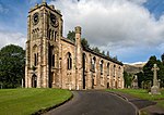
| Campsie High Church |
Lennoxtown
55° 58′ 31,7″ N, 4° 11′ 59,3″ W55.975472222222-4.1998055555556 |
Kirchenruine |
4353 |
 |
| Lennox Castle |
nahe Lennoxtown
55° 58′ 38,5″ N, 4° 14′ 7,9″ W55.977361111111-4.2355277777778 |
Schlossruine |
4354 |
 |
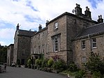
| Kincaid House |
Milton of Campsie
55° 57′ 29,5″ N, 4° 9′ 50,3″ W55.958194444444-4.1639722222222 |
Herrenhaus |
4357 |
|
| 27 Victoria Road |
Lenzie
55° 55′ 4,2″ N, 4° 9′ 14″ W55.917833333333-4.1538888888889 |
Villa |
4407 |
|
| Warwick Croft |
Lenzie
55° 55′ 3,2″ N, 4° 9′ 20,9″ W55.917555555556-4.1558055555556 |
Villa |
4408 |
 |
| Bardowie Castle |
nahe Milngavie
55° 56′ 7,6″ N, 4° 16′ 39″ W55.935444444444-4.2775 |
Tower House |
5726 |
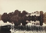 |
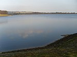
| Mugdock and Craigmaddie Reservoir |
Milngavie
55° 57′ 3,2″ N, 4° 18′ 18,7″ W55.950888888889-4.3051944444444 |
Stausee |
18227 |
 |
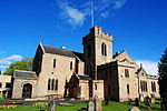
| New Kilpatrick Parish Church |
Bearsden
55° 55′ 16,6″ N, 4° 19′ 58,1″ W55.921277777778-4.3328055555556 |
Kirche |
22130 |
 |
| Kilmardinny House |
Bearsden
55° 55′ 33″ N, 4° 19′ 19″ W55.925833333333-4.3219444444444 |
Villa |
22135 |
 |
| Cawder House |
nahe Bishopbriggs
55° 55′ 37,3″ N, 4° 13′ 58,7″ W55.927027777778-4.2329722222222 |
Herrenhaus |
22272 |
 |
| Old Parish Church of St. Mary |
Kirkintilloch
55° 56′ 27″ N, 4° 9′ 33,7″ W55.940833333333-4.1593611111111 |
Kirche |
36645 |
 |
| Auld Aisle Cemetery |
Kirkintilloch
55° 55′ 56,7″ N, 4° 8′ 18,3″ W55.932416666667-4.1384166666667 |
Friedhof |
36646 |
 |
| Luggie Water Aqueduct |
Kirkintilloch
55° 56′ 22,8″ N, 4° 9′ 4″ W55.939666666667-4.1511111111111 |
Aquädukt |
36655 |
 |
| Factor’s House |
Milngavie
55° 56′ 12,1″ N, 4° 17′ 41,9″ W55.936694444444-4.2949722222222 |
Wohngebäude |
37847 |
|
| Glenshira |
Bearsden
55° 55′ 14,6″ N, 4° 18′ 51″ W55.920722222222-4.3141666666667 |
Villa |
48593 |
|
|


.jpg)


