File:ElectoralCollege1996-Large.png
aus Wikipedia, der freien encyclopedia
Größe dieser Vorschau: 800 × 430 Pixel. Weitere Auflösungen: 320 × 172 Pixel | 640 × 344 Pixel | 1.182 × 635 Pixel
Originaldatei (1.182 × 635 Pixel, Dateigröße: 171 KB, MIME-Typ: image/png)
![]()
Diese Datei und die Informationen unter dem roten Trennstrich werden aus dem zentralen Medienarchiv Wikimedia Commons eingebunden.
![]()
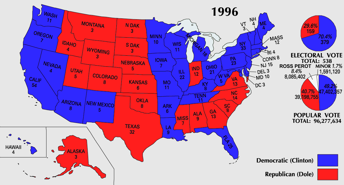
| U.S. presidential election maps from the National Atlas of the United States |
| See also: SVG maps |
| 1789 · 1792 · 1796 · 1800 · 1804 · 1808 · 1812 · 1816 · 1820 · 1824 · 1828 · 1832 · 1836 · 1840 · 1844 · 1848 · 1852 · 1856 · 1860 · 1864 · 1868 · 1872 · 1876 · 1880 · 1884 · 1888 · 1892 · 1896 · 1900 · 1904 · 1908 · 1912 · 1916 · 1920 · 1924 · 1928 · 1932 · 1936 · 1940 · 1944 · 1948 · 1952 · 1956 · 1960 · 1964 · 1968 · 1972 · 1976 · 1980 · 1984 · 1988 · 1992 · 1996 · 2000 · 2004 · 2008 · 2012 |
Beschreibung


.png)
Lizenz
| Public domainPublic domainfalsefalse |
Diese Karte stammt aus einer Ausgabe des National Atlas of the United States. Wie fast alle Arbeiten der Regierung der Vereinigten Staaten sind Arbeiten des National Atlas in den USA gemeinfrei.
Online-Zugang: NationalAtlas.gov | Gedruckte Ausgabe von 1970: Library of Congress, Perry-Castañeda Library čeština | Deutsch | English | français | Bahasa Indonesia | italiano | македонски | മലയാളം | sicilianu | 中文 | 中文(简体) | 中文(繁體) | +/− |
Dateiversionen
Klicke auf einen Zeitpunkt, um diese Version zu laden.
| Version vom | Vorschaubild | Maße | Benutzer | Kommentar | |
|---|---|---|---|---|---|
| aktuell | 12:21, 25. Jul. 2007 | | 1.182 × 635 (171 KB) | Cardsplayer4life~commonswiki | Reverted to earlier revision |
| 11:25, 25. Jul. 2007 |  | 1.182 × 635 (110 KB) | Joseph Solis in Australia~commonswiki | {{PD-USGov-Atlas}} Category:1996 {{US presidential election maps}} | |
| 03:48, 9. Jul. 2007 |  | 1.182 × 635 (171 KB) | Cardsplayer4life~commonswiki | {{PD-USGov-Atlas}} Category:1996 {{US presidential election maps}} | |
| 11:31, 6. Jul. 2007 |  | 1.182 × 635 (110 KB) | Joseph Solis in Australia~commonswiki | {{PD-USGov-Atlas}} Category:1996 {{US presidential election maps}} | |
| 04:30, 2. Jul. 2007 |  | 1.182 × 635 (171 KB) | Cardsplayer4life~commonswiki | {{PD-USGov-Atlas}} Category:1996 {{US presidential election maps}} | |
| 12:06, 29. Jun. 2007 |  | 1.182 × 635 (110 KB) | Joseph Solis in Australia~commonswiki | {{PD-USGov-Atlas}} Category:1996 {{US presidential election maps}} | |
| 23:02, 21. Jun. 2007 |  | 1.182 × 635 (171 KB) | Cardsplayer4life~commonswiki | {{PD-USGov-Atlas}} Category:1996 {{US presidential election maps}} | |
| 17:57, 22. Jan. 2006 |  | 1.182 × 635 (110 KB) | Red devil 666 | {{PD-USGov-Atlas}} |
Dateiverwendung
Keine Seiten verwenden diese Datei.
Globale Dateiverwendung
Die nachfolgenden anderen Wikis verwenden diese Datei:
- Verwendung auf en.wikipedia.org
- Verwendung auf sv.wikipedia.org
- Verwendung auf uk.wikipedia.org