Loading AI tools
Apátistvánfalva (slowenisch Števanovci, deutsch Stephansdorf in der Wart) ist eine ungarische Gemeinde im Kreis Szentgotthárd im Komitat Vas.
| Apátistvánfalva | |||||
| |||||
| Basisdaten | |||||
|---|---|---|---|---|---|
| Staat: | |||||
| Region: | Westtransdanubien | ||||
| Komitat: | Vas | ||||
| Kleingebiet bis 31.12.2012: | Szentgotthárd | ||||
| Kreis: | Szentgotthárd | ||||
| Koordinaten: | 46° 54′ N, 16° 15′ O | ||||
| Fläche: | 12,86 km² | ||||
| Einwohner: | 394 (1. Jan. 2022) | ||||
| Bevölkerungsdichte: | 31 Einwohner je km² | ||||
| Telefonvorwahl: | (+36) 94 | ||||
| Postleitzahl: | 9982 | ||||
| KSH-kód: | 08873 | ||||
| Struktur und Verwaltung (Stand: 2018) | |||||
| Gemeindeart: | Gemeinde | ||||
| Bürgermeister: | Csaba Császár-Bartakovics (parteilos) | ||||
| Postanschrift: | Fő út 107 9982 Apátistvánfalva | ||||
| Website: | |||||
| (Quelle: Localities 01.01.2022. bei Központi statisztikai hivatal) | |||||


Apátistvánfalva liegt sechs Kilometer südlich der Stadt Szentgotthárd, zweieinhalb Kilometer nördlich der Grenze zu Slowenien, an dem kleinen Fluss Hársas-patak. Nachbargemeinden sind Orfalu und Kétvölgy.
- Károly Krajczár (1936–2018), Autor, Pädagoge und Volksmärchensammler

- Grenzwacht-Gedenkstätte und Museum (Határőr Emlékhely és Múzeum)
- Im Museum befindet sich eine Statue von Szent László, dem Schutzpatron der Grenzwächter (Szent László, a határőrök védőszentje szobra)
- Mariensäule (Mária-oszlop), erschaffen 1899 von József Hudetz
- Naturlehrpfad Rókagomba tanösvény
- Römisch-katholische Kirche Harding Szent István, erbaut um 1786 (Spätbarock)
- Weltkriegsdenkmal (Hősi halottak emlékműve) mit Statue von Árpád, erschaffen 1925 von Ede Kallós
In Apátistvánfalva trifft die Landstraße Nr. 7456 auf die Nr. 7458, die in südwestlicher Richtung zur slowenischen Grenze führt. Der nächstgelegene Bahnhof befindet sich in Szentgotthárd.
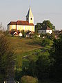 Röm.-kath. Kirche Harding Szent István
 Hauptaltar der Kirche
 Seitenaltar
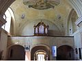 Blick auf die Orgel
 Kapelle
 Kreuz
Kreuz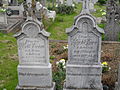 Grabsteine auf dem Friedhof
 Weltkriegsdenkmal mit Árpád-Statue
 Zweisprachige Ortstafel auf Ungarisch und Slowenisch


.JPG)


- Apátistvánfalva – Településképi Arculati Kézikönyv 2017. Hrsg. von der Gemeindeverwaltung.
Commons: Apátistvánfalva – Sammlung von Bildern, Videos und Audiodateien
- Offizielle Website (ungarisch und slowenisch)
- Apátistvánfalva község címere (ungarisch)
Wikiwand in your browser!
Seamless Wikipedia browsing. On steroids.
Every time you click a link to Wikipedia, Wiktionary or Wikiquote in your browser's search results, it will show the modern Wikiwand interface.
Wikiwand extension is a five stars, simple, with minimum permission required to keep your browsing private, safe and transparent.