Fil:Topography_of_Bali.jpg
From Wikipedia, the free encyclopedia
Fuld opløsning (1.669 × 1.217 billedpunkter, filstørrelse: 498 KB, MIME-type: image/jpeg)
|
|
Denne fil er fra Wikimedia Commons. Beskrivelsen af filen fra Commons er gengivet nedenfor. |
| Public domainPublic domainfalsefalse |
| Denne fil er i offentligt domæne i USA fordi den udelukkende er skabt af NASA. NASAs ophavsretspolitik erklærer at materiale udgivet af NASA ikke er omfattet af ophavsret medmindre andet er nævnt. (Se også Template:PD-USGov, NASAs ophavsretspolitik eller JPLs politik for brug af billeder.) | ||
 |
Advarsler:
|

- Image Policy at: http://earthobservatory.nasa.gov/masthead.html
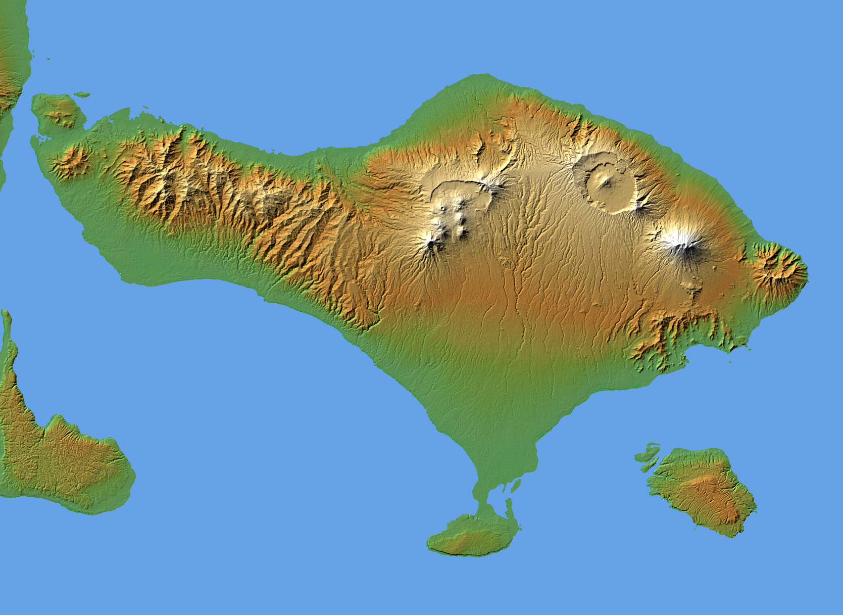
Topography of Bali
The volcanic nature of the island of Bali is evident in this shaded relief image generated with data from the Shuttle Radar Topography Mission (SRTM).
Bali, along with several smaller islands, make up one of the 27 Provinces of Indonesia. It lies over a major subduction zone where the Indo-Australian tectonic plate collides with the Sunda plate, creating one of the most volcanically active regions on the planet.
The most significant feature on Bali is Gunung Agung, the symmetric, conical mountain at the right-center of the image. This "stratovolcano," 3,148 meters (10,308 feet) high, is held sacred in Balinese culture, and last erupted in 1963 after being dormant and thought inactive for 120 years. This violent event resulted in over 1,000 deaths, and coincided with a purification ceremony called Eka Dasa Rudra, meant to restore the balance between nature and man. This most important Balinese rite is held only once per century, and the almost exact correspondence between the beginning of the ceremony and the eruption is believed by those involved to have great religious significance.
Two visualization methods were combined to produce the image: shading and color coding of topographic height. The shade image was derived by computing topographic slope in the northwest-southeast direction, so that northwest slopes appear bright and southeast slopes appear dark. Color coding is directly related to topographic height, with green at the lower elevations, rising through yellow and tan, to white at the highest elevations.
Elevation data used in this image were acquired by the Shuttle Radar Topography Mission aboard the Space Shuttle Endeavour, launched on Feb. 11, 2000. SRTM used the same radar instrument that comprised the Spaceborne Imaging Radar-C/X-Band Synthetic Aperture Radar (SIR-C/X-SAR) that flew twice on the Space Shuttle Endeavour in 1994. SRTM was designed to collect 3-D measurements of the Earth's surface. To collect the 3-D data, engineers added a 60-meter (approximately 200-foot) mast, installed additional C-band and X-band antennas, and improved tracking and navigation devices. The mission is a cooperative project between NASA, the National Geospatial-Intelligence Agency (NGA) of the U.S. Department of Defense and the German and Italian space agencies. It is managed by NASA's Jet Propulsion Laboratory, Pasadena, Calif., for NASA's Earth Science Enterprise, Washington, D.C.
- Location: 8.33 degrees South latitude, 115.17 degrees East longitude
- Orientation: North toward the top, Mercator projection
- Size: 153 by 112 kilometers (95 by 69 miles)
- Image Data: shaded and colored SRTM elevation model
- Date Acquired: February 2000
Image Courtesy SRTM Team NASA/JPL/NIMA
nb: Originally uploaded by me, Jack Merridew, as w:User:Davenbelle, on en:wp:
Filhistorik
Klik på en dato/tid for at se filen som den så ud på det tidspunkt.
| Dato/tid | Miniaturebillede | Dimensioner | Bruger | Kommentar | |
|---|---|---|---|---|---|
| nuværende | 28. jun. 2005, 21:00 | | 1.669 × 1.217 (498 KB) | Igiveup | {{PD-USGov-NASA}} Source: [http://earthobservatory.nasa.gov/Newsroom/NewImages/Images/PIA04950_lrg.jpg http://earthobservatory.nasa.gov/Newsroom/NewImages/Images/PIA04950_lrg.jpg] |
Filanvendelse
Der er ingen sider der bruger denne fil.
Global filanvendelse
Følgende andre wikier anvender denne fil:
- Anvendelser på fr.wikipedia.org
- Anvendelser på it.wikipedia.org
- Anvendelser på ja.wikipedia.org
- Anvendelser på ru.wikipedia.org
- Anvendelser på tt.wikipedia.org
- Anvendelser på www.wikidata.org
Metadata
Denne fil indeholder ekstra information, som formentlig er tilføjet fra et digitalt kamera eller en skanner, der enten blev brugt til at skabe billede eller digitalisere det. Hvis filen har været ændret siden dens oprindelige tilblivelse, kan nogle detaljer muligvis ikke fuldt ud repræsentere det modificerede billede.
| Billedets titel | converted PNM file |
|---|---|
| Kameraretning | Normal |
| Vandret opløsning | 72 dpi |
| Lodret opløsning | 72 dpi |
| Software | Adobe Photoshop 7.0 |
| Dato og tid for ændring af fil | 27. jan. 2004, 13:41 |
| Farverum | Ukalibreret |