Fil:China-Ningxia.png
From Wikipedia, the free encyclopedia
Der findes ingen højere opløsning af billedet
China-Ningxia.png (268 × 218 billedpunkter, filstørrelse: 15 KB, MIME-type: image/png)
|
|
Denne fil er fra Wikimedia Commons. Beskrivelsen af filen fra Commons er gengivet nedenfor. |
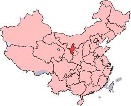
en: Location of Ningxia Hui Autonomous Region in the People's Republic of China. See Locator maps of province-level divisions of the People's Republic of China for more information.
zh: 寧夏回族自治區在中華人民共和國的位置。另見Locator maps of province-level divisions of the People's Republic of China。

|
Tilladelse er givet til at kopiere, distribuere og/eller ændre dette dokument under betingelserne i GNU Free Documentation License', Version 1.2 eller enhver senere version udgivet af Free Software Foundation; uden et invariant afsnit, ingen forsidetekster, og ingen bagsidetekst. En kopi af licensen er inkluderet i afsnittet GNU Free Documentation License.http://www.gnu.org/copyleft/fdl.htmlGFDLGNU Free Documentation Licensetruetrue |
| Denne fil er udgivet under Creative Commons Kreditering-Del på samme vilkår 3.0 Ikke-porteret-licensen. | ||
| ||
| Denne licens blev tilføjet som en del af GFDL-licensopdateringen.http://creativecommons.org/licenses/by-sa/3.0/CC BY-SA 3.0Creative Commons Attribution-Share Alike 3.0truetrue |
Captions
Tilføj en kort forklaring på en enkelt linje om hvad filen viser
Elementer som er med i denne fil
afbilder
image/png
e0878455c9788291f46f49b46dfa256ec7252ee9
15.857 Byte
218 pixel
268 pixel
Filhistorik
Klik på en dato/tid for at se filen som den så ud på det tidspunkt.
| Dato/tid | Miniaturebillede | Dimensioner | Bruger | Kommentar | |
|---|---|---|---|---|---|
| nuværende | 15. jul. 2005, 16:56 | | 268 × 218 (15 KB) | Schaengel89~commonswiki | transparent background |
| 5. jun. 2005, 00:40 |  | 268 × 218 (9 KB) | Ran | '''en''': Location of Ningxia Hui Autonomous Region in the People's Republic of China. See Category:Locator maps of province-level divisions of the People's Republic of China for more information. '''zh''': 寧夏回族自治區在中華人民共和 |
Filanvendelse
Den følgende side bruger denne fil:
Global filanvendelse
Følgende andre wikier anvender denne fil:
- Anvendelser på de.wikipedia.org
- Anvendelser på en.wikipedia.org
- Wikipedia:WikiProject Chinese provinces/Locator maps
- Shapotou, Zhongwei
- Zhangyi
- Qingtongxia
- Yinchuan Helanshan Airport
- Template:Ningxia-geo-stub
- Xingqing, Yinchuan
- Jinfeng, Yinchuan
- Xixia, Yinchuan
- Yongning County
- Helan County
- Zhongning County
- Haiyuan County
- Dawukou, Shizuishan
- Huinong, Shizuishan
- Pingluo County
- Litong, Wuzhong
- Yanchi County
- Jingyuan County, Ningxia
- Pengyang County
- Yuanzhou, Guyuan
- Xiji County
- Linhe, Ningxia
- Baima Township, Ningxia
- Yumin Subdistrict, Qingtongxia
- Xiaoba, Ningxia
- Shanhe Township
- Daba, Ningxia
- Xiakou, Ningxia
- Shaogang, Ningxia
- Daxin, Ningxia
- Yueyahu Township
- Zhangzheng
- Tonggui Township
- Xihuayuan Subdistrict, Yinchuan
- Xingjing, Ningxia
- Zhenbeibu
- Liangtian, Ningxia
- Fengdeng
- Yanghe Township, Ningxia
- Hechuan Township
- Renmin Road Subdistrict, Shizuishan
- Xuanhe, Ningxia
Vis flere globale anvendelser af denne fil.
Hentet fra "https://da.wikipedia.org/wiki/Fil:China-Ningxia.png"