Soubor:UNESCO_World_Heritage_Natural_Sites_by_Country.png
From Wikipedia, the free encyclopedia
Původní soubor (1 427 × 628 pixelů, velikost souboru: 44 KB, MIME typ: image/png)
| Tento soubor pochází z Wikimedia Commons. Níže jsou zobrazeny informace, které obsahuje jeho tamější stránka s popisem souboru. |
Popis
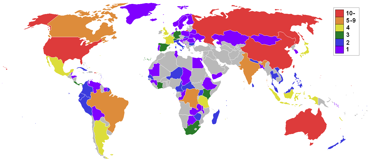
| PopisUNESCO World Heritage Natural Sites by Country.png | Map showing the Natural Heritage Sites distribution by State Parties. |
| Zdroj | Na Commons přeneseno z en.wikipedia. |
| Autor | Original uploader was user:Joey80 at en.wikipedia |
Licence
|
NOTE: "subject to disclaimers" below may not actually apply, this was tagged with {{GFDL-user-en}}, and after May 2007, en:Template:GFDL-self did not require disclaimers. Please check the image description page on the English Wikipedia (or, if it has been deleted, ask an English Wikipedia administrator). See Wikipedia:GFDL standardization for details. | ||||||||
Joey80 from en.wikipedia.org, držitel autorských práv k tomuto dílu, ho tímto zveřejňuje za podmínek následující licence:
| ||||||||
|
Note: This tag should not be used. For images that were released on the English Wikipedia using either GFDL or GFDL-self with disclaimers, use {{GFDL-user-en-with-disclaimers}}. For images without disclaimers please use {{GFDL-user-en-no-disclaimers}} instead. If you are the copyright holder of files that were released on Wikipedia, please consider removing the disclaimers. |

Původní historie souboru
- 13:40, 29 June 2007 (CEST) user:Joey80 1427×628 (54 Kbytes)
Popisky
Položky vyobrazené v tomto souboru
zobrazuje
Historie souboru
Kliknutím na datum a čas se zobrazí tehdejší verze souboru.
| Datum a čas | Náhled | Rozměry | Uživatel | Komentář | |
|---|---|---|---|---|---|
| současná | 6. 3. 2018, 22:18 | | 1 427 × 628 (44 KB) | Maphobbyist | South Sudan border |
| 23. 6. 2014, 10:58 |  | 1 427 × 628 (39 KB) | Avis28 | Update 2014 | |
| 2. 7. 2012, 14:10 |  | 1 427 × 628 (36 KB) | Tragopogon | Update 2012 | |
| 1. 7. 2009, 04:25 |  | 1 427 × 628 (52 KB) | Joey80~commonswiki | updated for 2009 listings | |
| 5. 12. 2007, 15:38 |  | 1 427 × 628 (54 KB) | Szajci | == Опис == {{Information |Description=Map showing the Natural Heritage Sites distribution by State Parties. |Source=Originally from [http://en.wikipedia.org en.wikipedia]; description page is/was [http://en.wikipedia.org/w/index.php?title=Image:Natura |
Využití souboru
Tento soubor používá následující stránka:
Globální využití souboru
Tento soubor využívají následující wiki:
- Využití na af.wikipedia.org
- Využití na az.wikipedia.org
- Využití na de.wikipedia.org
- Využití na en.wikipedia.org
- Využití na fa.wikipedia.org
- Využití na hr.wikipedia.org
- Využití na it.wikipedia.org
- Využití na jv.wikipedia.org
- Využití na kn.wikipedia.org
- Využití na sh.wikipedia.org
- Využití na tr.wikipedia.org
Metadata
Tento soubor obsahuje dodatečné informace, poskytnuté zřejmě digitálním fotoaparátem nebo scannerem, kterým byl pořízen. Pokud byl soubor od té doby změněn, některé údaje mohou být neplatné.
| Rozlišení obrázku na šířku | 27,98 dpc |
|---|---|
| Rozlišení obrázku na výšku | 27,98 dpc |