Fayl:Caspian_Sea_from_orbit-NoRedLines.jpg
From Wikipedia, the free encyclopedia
Kerçek fayl (4.400 × 5.600 piksel, fayl büyükligi: 9,04 MB, MIME çeşiti: image/jpeg)
This file is from Wikimedia Commons and may be used by other projects. The description on its file description page there is shown below.
|
| TasvirCaspian Sea from orbit-NoRedLines.jpg |
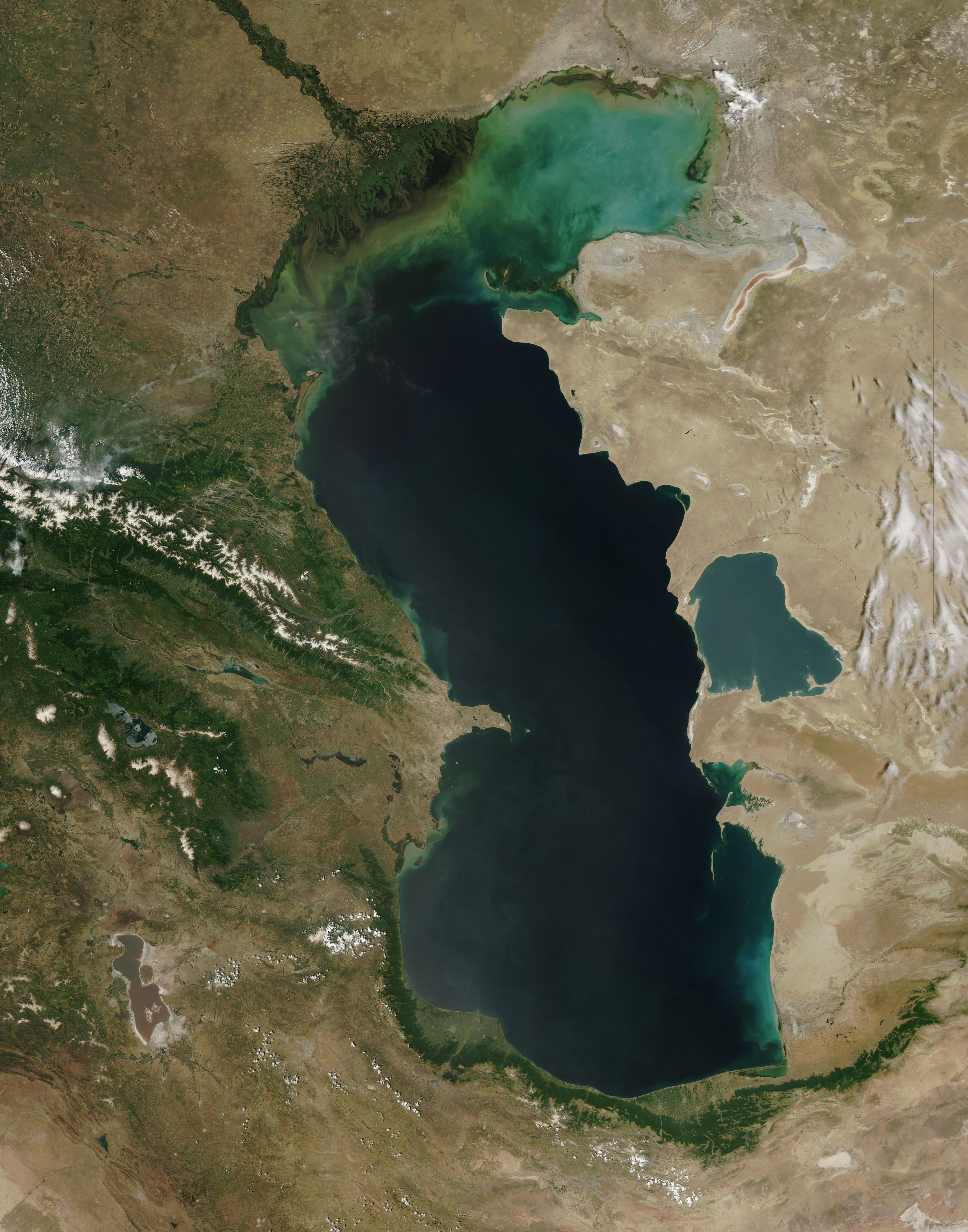
Español: El Mar Caspio visto desde la órbita terrestre English: This is a view from orbit of the Caspian Sea as imaged by the MODIS sensor on the Terra satellite. Caption: The original caption from NASA: ::"The northern part of the Caspian Sea is plagued by a process called eutrophication, in which agricultural run-off rich in fertilizers stimulates rampant growth of algae in the water. The death and decay of these algae robs the water of oxygen, with obvious negative consequences for aquatic life. This image of the Caspian Sea shows swirls of green and blue near the mouth of the Volga River (top center), which indicate the presence of algae. The bright blue color of the northeastern part of the sea may be due to a mixture of plant life and sediment, for this is where the sea is most shallow. This image is from the Moderate Resolution Imaging Spectroradiometer (MODIS) on the Terra satellite on June 11, 2003. |
| Tarih | (UTC) |
| Menba | |
| Yaratıcı |
|
| This is a retouched picture, which means that it has been digitally altered from its original version. Modifications: cloned out and healed little all the little red lines. The original can be viewed here: Caspian Sea from orbit.jpg:
|
| Public domainPublic domainfalsefalse |
| This file is in the public domain in the United States because it was solely created by NASA. NASA copyright policy states that "NASA material is not protected by copyright unless noted". (See Template:PD-USGov, NASA copyright policy page or JPL Image Use Policy.) | ||
 |
Warnings:
|
Original upload log
This image is a derivative work of the following images:
- File:Caspian_Sea_from_orbit.jpg licensed with PD-USGov-NASA
- 2010-06-14T09:16:01Z Originalwana 4400x5600 (3608474 Bytes) higher res
- 2005-02-08T15:10:25Z Pixeltoo 550x700 (68127 Bytes) Caspian sea by space [[Nasa]]
Uploaded with derivativeFX
Captions
Items portrayed in this file
depicts English
2 sentâbr 2010
media type English
image/jpeg
checksum English
7f60fbaa38498736f33f8a20c50fdfebaa6a0655
data size English
9.476.055 byte
height English
5.600 pixel
width English
4.400 pixel
Faylnıñ keçmişi
Faylnıñ kerekli anki alını körmek içün tarihqa/saatqa basıñız.
| Tarih ve saat | Kiçik resim | En × boy | Qullanıcı | İzaat | |
|---|---|---|---|---|---|
| şimdiki | 23:51, 2010 s. sentâbrniñ 2 | | 4.400 × 5.600 (9,04 MB) | IdLoveOne~commonswiki | cloning and healing |
| 16:19, 2010 s. sentâbrniñ 2 |  | 4.400 × 5.600 (9,04 MB) | IdLoveOne~commonswiki | more cleaning | |
| 16:07, 2010 s. sentâbrniñ 2 |  | 4.400 × 5.600 (9,04 MB) | IdLoveOne~commonswiki | cleaned more on lower left | |
| 15:46, 2010 s. sentâbrniñ 2 |  | 4.400 × 5.600 (9,04 MB) | IdLoveOne~commonswiki | {{Information |Description={{es|El '''Mar Caspio''' visto desde la órbita terrestre}} {{en|This is a view from orbit of the Caspian Sea as imaged by the MODIS sensor on the Terra satellite. '''Caption:''' The original caption from NASA: ::"The n |
Fayl qullanıluvı
Bu faylnı qullanğan saife yoq.
Umumiy fayl qullanıluvı
Bu vikilerde bu fayldı qullana:
- alt.wikipedia.org qullanım
- az.wikipedia.org qullanım
- ba.wikipedia.org qullanım
- ca.wikipedia.org qullanım
- ce.wikipedia.org qullanım
- Каспий-хӀорд
- Нохчийн гӀайре
- Кеп:Каспий-хӀордан гӀайренаш
- Адсыз ада
- Ӏашур-Ада
- Каспий-хӀордан гӀайренийн могӀам
- Кюр-Даши
- Хиль (гӀайре)
- Игнат даши
- Зенбиль
- ГӀум (гӀайре)
- Бёюк-Зиря
- Чигил
- Сенги-Муган
- Чилов гӀайре
- Яшма (гӀайре)
- Охана йаккхий гӀайренаш
- Джамбайн гӀайре
- Спиркин Осерёдок
- Тюленьи гӀайренаш
- Тюлений (Каспий-хӀорд)
- Верхни Осередок
- Нордови
- Чисти Банка
- Зюдев (гӀайре, Росси)
- Коневски
- Баткачни
- Лихачёв (гӀайре)
- Нижни (гӀайре)
- Мали Сетной
- Большой Сетной
- Мали Зюдостински
- Большой Зюдостински
- Огурджале
- Даш-Зиря
- Хере-Зиря
- Кюр-Дили
- Суатли адалари
- Гутан (гӀайре)
- Даш адалари
- Пираллахи (ахгӀайре)
- Бабурий
- Боьйуьк Тава
- Гарабаттаг (гӀайре)
- Гу (гӀайре)
- Дахили Даш
View more global usage of this file.
Resim detalleri
Faylda (adetince raqamlı kamera ve skanerlernen qoşulğan) ilâve malümatı bar. Eger bu fayl yaratılğandan soñ deñiştirilse edi, belki de bazı parametrler eskirdi.
| _error | 0 |
|---|