پەڕگە:Holy_Roman_Empire_1648.svg
From Wikipedia, the free encyclopedia

پەڕگەی سەرەکی (پەڕگەی SVG، بە ناو ٢٬٢٨٣ × ١٬٨١٠ پیکسەڵ، قەبارەی پەڕگە: ٣٫٠٧ مێگابایت)
ئەم پەڕگە لە Wikimedia Commonsەوەیە و لەوانەیە لە پڕۆژەکانی دیکەش بەکار ھاتبێت. پێناسەکەی لەسەر پەڕەی وەسفی پەڕگەکە لە خوارەوە نیشان دراوە.
کورتە
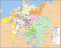
| وەسفHoly Roman Empire 1648.svg |
English: Map of the Holy Roman Empire in 1648, after the Peace of Westphalia which ended the Thirty Years' War. Deutsch: Karte des Heiligen Römischen Reiches 1648, nach dem Westfälischer Friede, der den Dreißigjähriger Krieg beendete. Français : Carte du Saint-Empire à 1648, après la paix de Westphalie qui mettent fin à la guerre de Trente Ans. Version française est disponible à File:Holy Roman Empire 1648 fr.svg. Српски / srpski: Мапа Светог римског царства у 1648, након Вестфалског мира којим је завршен Тридесетогодишњи рат.
|
English | Deutsch | Français | Српски |
||
|---|---|---|---|---|---|
| A | Archbishopric | Erzbistum | Archevêché | АДИЈ. | Архидијецеза |
| B | Bishopric | Bistum | Évêché | ДИЈ. | Дијецеза |
| C | County | Grafschaft | Comté | ОКР./ГРОФ. | Округ/грофовија |
| D | Duchy | Herzogtum | Duché | ВОЈВ. | Војводство |
| E | Electorate | Kurfürstentum | Électorat | ЕЛЕКТ. | Електорат |
| L | Landgraviate | Landgrafschaft | Landgraviat | ЛГРОФ. | Ландгрофовија |
| M | Margraviate | Markgrafschaft | Margraviat | МГРОФ. | Маркгрофовија |
| P | Principality | Fürstentum | Principauté | ГРОФ./ОКР. | Грофовија/округ |
Legend / Farblegende / Légende / Легенда
English | Deutsch | Français | Српски |
|
|---|---|---|---|---|
Palatinat des Wittelsbach |
||||
Wittelsbach Bavaria |
Wittelsbacher Bayern |
Bavière des Wittelsbach |
Вителсбах, баварски | |
Hohenzollern Franconia |
Hohenzollerner Franken |
Хоенцолерн, франконски | ||
Wettin Ernestine Saxony |
Wettiner Ernestiner Sachsen |
Saxe de la branche ernestine des Wettin |
Ветин, ернестински | |
Made from the public domain map "Central Europe about 1648" from the Historical Atlas by William R. Shepherd, at the Perry-Castañeda Library Map Collection at the University of Texas. Further information from Overy, Richard, 2006, The Times Complete history of the world Times Books ISBN 0007181299, and from this map
See also other maps at external links:
- Central Europe 1648
- Map on personal site, Europe in 1648
- Treaty of Westphalia
- 1648 map of Prussia
- Britannica, Spanish domains in 1648
(بەکارھێنانەوەی ئەم پەڕگەیە)

|
ڕێگەدراوە بە لەبەرگرتنەوە، دابەشکردن ھەروەھا/یان سازاندنی ئەم بەڵگەنامەیە لەژێر مەرجی مۆڵەتی GNU بۆ بەڵگەنامەی ئازاد، وەشانی ١.٢ یان ھەر وەشانێکی تری دواتر کە بڵاوکراوەتەوە لەلایەن دامەزراوەی بەرنامەی ئازاد، بەبێ ھیچ بەشێکی جیاواز، بەبێ نووسین لەسەر بەرگی پێشەوە و دواوەی. وێنەیەک لەمۆڵەتەکە لە بەشێکدا ھەیە کە ناوی مۆڵەتی GNU بۆ بەڵگەنامەی ئازادە.http://www.gnu.org/copyleft/fdl.htmlGFDLGNU Free Documentation Licensetruetrue |
| ئەم پەڕگەیە لە ژێر مۆڵەتنامەی | ||
| ||
| This licensing tag was added to this file as part of the GFDL licensing update.http://creativecommons.org/licenses/by-sa/3.0/CC BY-SA 3.0Creative Commons Attribution-Share Alike 3.0truetrue |
[دەستکاری]
-
 ئینگلیزی SVG
 -
 ئیسپانی SVG
 -
 فەرەنسی SVG
 -
 گۆرجستانی SVG
 -
 سربی SVG
 -
 English: Blank PNG
 -
 ئینگلیزی PNG
 -
 ئیسپانی PNG
 -
 سربی PNG
 -
 ڕووسی PNG


| This SVG file contains embedded text that can be translated into your language, using any capable SVG editor, text editor or the SVG Translate tool. For more information see: About translating SVG files. |
لێدوانەکان
بەندەکانی لەم پەڕگەیەدا دەردەکەون
depicts ئینگلیزی
some value
٢٩ کانوونی دووەمی 2007
media type ئینگلیزی
image/svg+xml
مێژووی پەڕگە
کرتە بکە لەسەر یەکێک لە ڕێکەوت/کاتەکان بۆ بینینی پەڕگەکە بەو شێوەی لەو کاتەدا بووە.
| ڕێکەوت/کات | ھێما | ئەندازە | بەکارھێنەر | تێبینی | |
|---|---|---|---|---|---|
| هەنووکە | ٢٠:٤٣، ٢٤ی تەممووزی ٢٠٢٢ | | ٢٬٢٨٣ لە ١٬٨١٠ (٣٫٠٧ مێگابایت) | Maproom | ZWEIBRCKEN -> ZWEIBRÜCKEN, Treves -> Trier, Liege -> Liège |
| ١٧:٥٥، ١٨ی ئایاری ٢٠٢٢ |  | ٢٬٢٨٣ لە ١٬٨١٠ (٣٫٠٧ مێگابایت) | Maproom | Consistent, and German, spelling of "Mainz" | |
| ٢٠:١١، ٢٥ی ئایاری ٢٠٢١ |  | ٢٬٢٨٣ لە ١٬٨١٠ (٣٫٠٧ مێگابایت) | ElCet | added the biggest city of Upper Silesia back then | |
| ١١:٣٤، ٢٣ی ئازاری ٢٠١٨ |  | ٢٬٢٨٣ لە ١٬٨١٠ (٣٫٠١ مێگابایت) | Valentinian | Cleanup some names including missing umlauts. Brunswick-Lüneburg -> Brunswick-Celle (see talk). Border north of Rendsburg seems slightly off to me and the situation in Holstein is rather simplified (jointly administered areas are missing). | |
| ١٩:٠٩، ٨ی تشرینی یەکەمی ٢٠١٠ |  | ٢٬٢٨٣ لە ١٬٨١٠ (٣٫٠١ مێگابایت) | Joostik | Ravenstein as part of Cleves | |
| ١٩:٤٥، ٩ی ئابی ٢٠٠٩ |  | ٢٬٢٨٣ لە ١٬٨١٠ (٣٫٠١ مێگابایت) | Ysangkok | simplify code (save as plain svg) | |
| ٠٩:٢٤، ١٤ی تەممووزی ٢٠٠٩ |  | ٢٬٢٨٣ لە ١٬٨١٠ (٤٫١٧ مێگابایت) | Roke~commonswiki | Zusmarshausen | |
| ١٥:١٦، ٢٠ی نیسانی ٢٠٠٧ |  | ٢٬٢٨٣ لە ١٬٨١٠ (٤٫١٢ مێگابایت) | Roke~commonswiki | ||
| ٠٢:٠٤، ٢٠ی نیسانی ٢٠٠٧ |  | ٢٬٢٨٣ لە ١٬٨١٠ (٤٫١١ مێگابایت) | Roke~commonswiki | rm HRE text, darken labels | |
| ٠٣:٠٤، ١٨ی نیسانی ٢٠٠٧ |  | ٢٬٢٨٣ لە ١٬٨١٠ (٤٫١١ مێگابایت) | Roke~commonswiki |
بەکارھێنانی پەڕگە
ئەم پەڕەیە ئەم پەڕگەیە بەکار دەھێنێت:
بەکارھێنانی سەرانسەریی پەڕگە
ئەم ویکیانەی دیکەی خوارەوەش ئەم پەڕگە بەکاردێنن:
- بەکارھێنان لە af.wikipedia.org
- بەکارھێنان لە azb.wikipedia.org
- بەکارھێنان لە az.wikipedia.org
- بەکارھێنان لە br.wikipedia.org
- بەکارھێنان لە ca.wikipedia.org
- بەکارھێنان لە cs.wikipedia.org
- بەکارھێنان لە el.wikipedia.org
- بەکارھێنان لە en.wikipedia.org
- Peace of Westphalia
- Thirty Years' War
- Germans
- Wikipedia:WikiProject Maps
- Imperial Estate
- Talk:Paul Skalich
- Treaty of Fontainebleau (1631)
- Wikipedia:Featured picture candidates/Holy Roman Empire in 1648
- Wikipedia:Featured picture candidates/May-2007
- User talk:Giano II/archive 7
- User:Luosiji/Sandbox
- User:Jammydodger/HRE
- Germany in the early modern period
- User:Zealotzuo/Sandbox
- Wikipedia talk:WikiProject Maps/Archive 5
- Territorial evolution of France
- User:Oaholroyd/sandbox
- User:JMvanDijk/Sandbox 10
- User:DyinRich/Something Else
- Aftermath of the Eighty Years' War
- User:Falcaorib/Germany and Prussia
- بەکارھێنان لە eo.wikipedia.org
- بەکارھێنان لە et.wikipedia.org
- بەکارھێنان لە fa.wikipedia.org
- بەکارھێنان لە fi.wikipedia.org
- بەکارھێنان لە fy.wikipedia.org
- بەکارھێنان لە hu.wikipedia.org
- بەکارھێنان لە hy.wikipedia.org
- بەکارھێنان لە id.wikipedia.org
- بەکارھێنان لە it.wikipedia.org
بینینی بەکارھێنانی گشتی زیاتری ئەم پەڕگەیە.
دراوی مێتا
ئەم پەڕگە زانیاری زێدەی ھەیە، کە لەوە دەچێت کامێرا یان ھێماگر (scanner) خستبێتیە سەری. ئەگەر پەڕگەکە لە حاڵەتی سەرەتاییەکەیەوە دەستکاری کرابێ، شایەد بڕێ لە بڕگەکان بە تەواوی زانیارەکانی وێنە گۆڕدراوەکە نیشان نەدەن.
| پانی | 2283 |
|---|---|
| بەرزی | 1810 |