File:Public_Schools_Historical_Atlas_-_Europe_13th_century.jpg
From Wikipedia, the free encyclopedia
قەبارەی ئەم پێشبینینە: ٧٣٩ لە ٥٩٩ پیکسەڵ. ڕێزەلووشنەکانی تر: ٢٩٦ لە ٢٤٠ پیکسەڵ | ٥٩٢ لە ٤٨٠ پیکسەڵ | ٩٤٧ لە ٧٦٨ پیکسەڵ | ١٬١٣٢ لە ٩١٨ پیکسەڵ.
پەڕگەی سەرەکی (١٬١٣٢ × ٩١٨ پیکسڵ، قەبارەی پەڕگە: ٣٧٤ کیلۆبایت، جۆری ئێم ئای ئێم ئی: image/jpeg)
ئەم پەڕگە لە Wikimedia Commonsەوەیە و لەوانەیە لە پڕۆژەکانی دیکەش بەکار ھاتبێت. پێناسەکەی لەسەر پەڕەی وەسفی پەڕگەکە لە خوارەوە نیشان دراوە.
کورتە
| وەسفPublic Schools Historical Atlas - Europe 13th century.jpg |
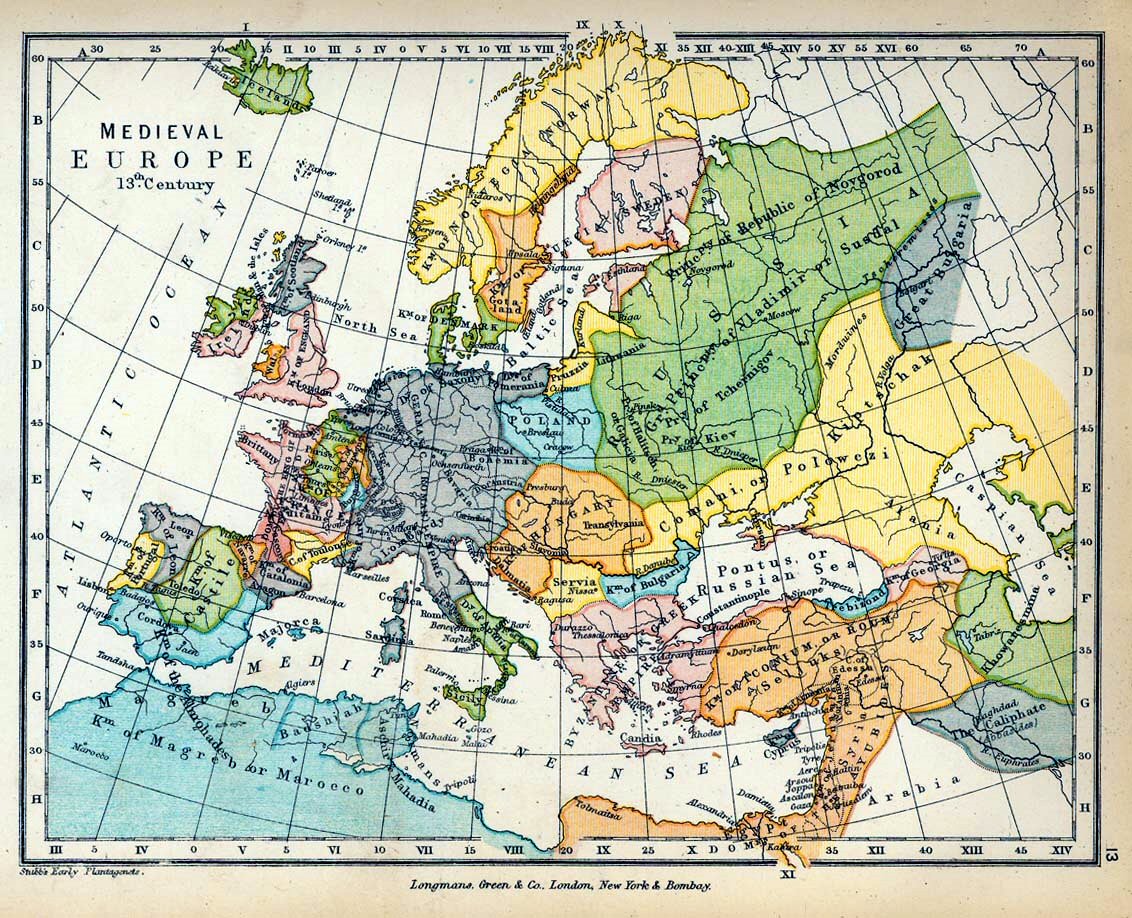
English: Map of Medieval Europe in the 13th Century. |
| ڕێکەوت | |
| سەرچاوە |
|
| بەرھەمھێنەر |
|
_en.png)
.png)
.jpg)
مۆڵەتنامە
| Public domainPublic domainfalsefalse |
This media file is in the public domain in the United States. This applies to U.S. works where the copyright has expired, often because its first publication occurred prior to January 1, 1929, and if not then due to lack of notice or renewal. See this page for further explanation.
|
 | |
 |
This image might not be in the public domain outside of the United States; this especially applies in the countries and areas that do not apply the rule of the shorter term for US works, such as Canada, Mainland China (not Hong Kong or Macao), Germany, Mexico, and Switzerland. The creator and year of publication are essential information and must be provided. See Wikipedia:Public domain and Wikipedia:Copyrights for more details.
|
لێدوانەکان
Add a one-line explanation of what this file represents
pkkghhkhg
بەندەکانی لەم پەڕگەیەدا دەردەکەون
depicts ئینگلیزی
1905
media type ئینگلیزی
image/jpeg
مێژووی پەڕگە
کرتە بکە لەسەر یەکێک لە ڕێکەوت/کاتەکان بۆ بینینی پەڕگەکە بەو شێوەی لەو کاتەدا بووە.
| ڕێکەوت/کات | ھێما | ئەندازە | بەکارھێنەر | تێبینی | |
|---|---|---|---|---|---|
| هەنووکە | ٠٩:٣٦، ١٩ی حوزەیرانی ٢٠٠٩ | | ١٬١٣٢ لە ٩١٨ (٣٧٤ کیلۆبایت) | Yarl | == {{int:filedesc}} == {{Information |Description={{en|Map of Medieval Europe in the 13th Century.}} |Source= * ''The Public Schools Historical Atlas'' by Charles Colbeck. Longmans, Green; New York; London; Bombay. 1905. * [http://www.lib.utexas.edu/maps/ |
بەکارھێنانی پەڕگە
ھیچ پەڕەیەک نییە کە ئەم پەڕگەیە بەکاربھێنێت.
بەکارھێنانی سەرانسەریی پەڕگە
ئەم ویکیانەی دیکەی خوارەوەش ئەم پەڕگە بەکاردێنن:
- بەکارھێنان لە en.wikipedia.org
- بەکارھێنان لە fr.wiktionary.org
- بەکارھێنان لە it.wikipedia.org
- بەکارھێنان لە no.wikipedia.org
دراوی مێتا
ئەم پەڕگە زانیاری زێدەی ھەیە، کە لەوە دەچێت کامێرا یان ھێماگر (scanner) خستبێتیە سەری. ئەگەر پەڕگەکە لە حاڵەتی سەرەتاییەکەیەوە دەستکاری کرابێ، شایەد بڕێ لە بڕگەکان بە تەواوی زانیارەکانی وێنە گۆڕدراوەکە نیشان نەدەن.
| _error | ٠ |
|---|