File:Europe_1867_map_en.png
From Wikipedia, the free encyclopedia
قەبارەی ئەم پێشبینینە: ٨٠٠ لە ٥٢٦ پیکسەڵ. ڕێزەلووشنەکانی تر: ٣٢٠ لە ٢١١ پیکسەڵ | ٦٤٠ لە ٤٢١ پیکسەڵ | ١٬٠٢٤ لە ٦٧٤ پیکسەڵ | ١٬٢٨٠ لە ٨٤٢ پیکسەڵ | ٢٬٢٨٤ لە ١٬٥٠٣ پیکسەڵ.
پەڕگەی سەرەکی (٢٬٢٨٤ × ١٬٥٠٣ پیکسڵ، قەبارەی پەڕگە: ١٫٠٧ مێگابایت، جۆری ئێم ئای ئێم ئی: image/png)
ئەم پەڕگە لە Wikimedia Commonsەوەیە و لەوانەیە لە پڕۆژەکانی دیکەش بەکار ھاتبێت. پێناسەکەی لەسەر پەڕەی وەسفی پەڕگەکە لە خوارەوە نیشان دراوە.
کورتە
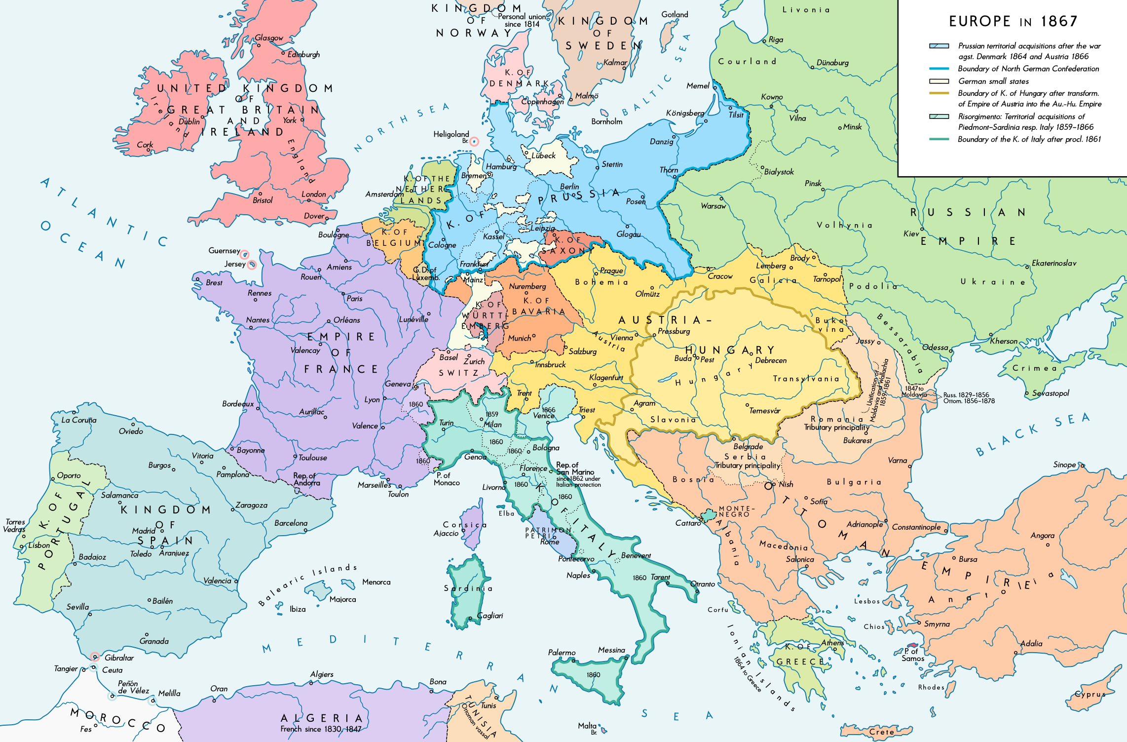
| وەسفEurope 1867 map en.png |
English: Europe 1867. Historical map of the political situation after the forming of the North German Confederation, the Italian Risorgimento (with the exception of the Roman part of the Papal States) and the Austro-Hungarian Compromise of 1867. Please don't alter the map, when you think there something not written or depicted correctly. Leave a message at the talk page of the file. After a verificiation and a possible discussion, i will upload a new map version with all new changes. This prevents an unnecessary waste of disc space and ensures a good result, aesthetically and contentwise. - The author. Deutsch: Europa 1867. Historische Karte der politischen Situation in Europa nach der Gründung des Norddeutschen Bundes, des italienischen Risorgimento (mit Ausnahme des röm. Teils des Kirchenstaats) und dem Österreichisch-Ungarischen Ausgleich von 1867. Bitte die Karte bei Änderungs- und Korrekturwünschen nicht selbst verändern, sondern eine Anmerkung im Diskussionsbereich der Bilddatei hinterlassen. Nach einer Prüfung und ggfs. Diskussion werden evtl. Änderungen von mir zusammengefasst eingearbeitet. Das vermeidet unnötige Speicherplatz-Verschwendung und gewährleistet ein ästhetisch ansprechendes und inhaltlich korrektes Ergebnis. - Der Urheber. |
| ڕێکەوت | |
| سەرچاوە |
بەرھەمی خۆم. Source of Information: Historical atlases and maps – Ramsay Muir, George Philip (ed.): Philip's New School Atlas of Universal History, George Philip & Son, Ltd., London 1928 – Dr. Walter Leisering (ed.): Putzger Historischer Weltatlas, Cornelsen Verlag, Berlin 1992, ISBN 3-464-00176-8 – Bayerischer Schulbuch-Verlag (ed.): Großer Historischer Weltatlas, Dritter Teil, Neuzeit, Bayerischer Schulbuch-Verlag, München 1981, ISBN 3-7627-6021-7. – Prof. Dr. Vadim Oswalt u. Prof. Dr. Hans Ulrich Rudolf (ed.): Klett-Perthes Atlas zur Weltgeschichte, Ernst Klett Verlag, Stuttgart 2011, ISBN 978-3-12-828194-0 – Ziegelbrenner: Karte des Norddeutschen Bundes 1866–1871, 6 June 2014 version (map link) Other publications – Francesco Traniello u. Gianni Sofri: Der lange Weg zur Nation. Das italienische Risorgimento, Verlag W. Kohlhammer, Stuttgart 2012, ISBN 978-3-17-021898-7 |
| بەرھەمھێنەر | Alexander Altenhof |
| وەشانەکانی تر |
|

Recompressed without quality loss with OptiPNG (1.35 MB > 1.06 MB)
مۆڵەتنامە
من، ھەڵگری مافی لەبەرگرتنەوەی ئەم بەرھەمە، لەژێر ئەم مۆڵەتنامەیەدا بڵاوی دەکەمەوە:
This file is licensed under the Creative Commons Attribution-Share Alike 4.0 International license.
- تۆ ئازادی:
- بۆ بڵاکردنەوە – بۆ کۆپی کردن، دابەشکردن و دەستبەدەست ناردنی
- بۆ تێکەڵکردنەوە – بۆ سازاندنی کارەکە
- بەم مەرجانەی خوارەوە:
- دانەپاڵ – پێویستە باوەڕی گونجاو بدەیت، بەستەرێک بۆ مۆڵەتەکە دابین بکەیت و ئاماژە بەوە بکەیت کە ئایا گۆڕانکاری کراوە یان نا. دەتوانیت بە هەر شێوەیەکی گونجاو ئەوە بکەیت، بەڵام بە شێوەیەک نا کە وا دەربکەوێت کە مۆڵەتدەر پشتگیری تۆ یان بەکارهێنانەکەت بکات.
- بڵاوکردنەوەی گونجاو – ئەگەر لەسەر بنەمای ئەم کارە تێکەڵ، گۆڕان، یان ساز بکەی، پێویستە بەشدارییەکانت بە هەمان مۆڵەت یان هاوشێوەی مۆڵەتی ئەسڵی دابەش بکەی.
لێدوانەکان
Add a one-line explanation of what this file represents
بەندەکانی لەم پەڕگەیەدا دەردەکەون
depicts ئینگلیزی
some value
٤ ئەیلوولی 2016
source of file ئینگلیزی
original creation by uploader ئینگلیزی
مێژووی پەڕگە
کرتە بکە لەسەر یەکێک لە ڕێکەوت/کاتەکان بۆ بینینی پەڕگەکە بەو شێوەی لەو کاتەدا بووە.
| ڕێکەوت/کات | ھێما | ئەندازە | بەکارھێنەر | تێبینی | |
|---|---|---|---|---|---|
| هەنووکە | ٢٣:٤٢، ١٤ی نیسانی ٢٠١٧ | | ٢٬٢٨٤ لە ١٬٥٠٣ (١٫٠٧ مێگابایت) | KaterBegemot | Empire of France (not Kingdom), changed main caption to "Europe in 1867", fixed font size of "Piedmont-Sardinia", minor changes |
| ٢١:٣٦، ٤ی ئەیلوولی ٢٠١٦ |  | ٢٬٢٨٤ لە ١٬٥٠٣ (١٫٠٦ مێگابایت) | KaterBegemot | {{Information |Description ={{en|1=Europe 1867. Historical map of the political situation after the forming of the North German Confederation, the Italian Risorgimento (with the exception of the Roman part of the Papal States) and the Austro-Hungari... |
بەکارھێنانی پەڕگە
ھیچ پەڕەیەک نییە کە ئەم پەڕگەیە بەکاربھێنێت.
بەکارھێنانی سەرانسەریی پەڕگە
ئەم ویکیانەی دیکەی خوارەوەش ئەم پەڕگە بەکاردێنن:
- بەکارھێنان لە ast.wikipedia.org
- بەکارھێنان لە en.wikipedia.org
- بەکارھێنان لە et.wikipedia.org
- بەکارھێنان لە it.wikipedia.org
دراوی مێتا
ئەم پەڕگە زانیاری زێدەی ھەیە، کە لەوە دەچێت کامێرا یان ھێماگر (scanner) خستبێتیە سەری. ئەگەر پەڕگەکە لە حاڵەتی سەرەتاییەکەیەوە دەستکاری کرابێ، شایەد بڕێ لە بڕگەکان بە تەواوی زانیارەکانی وێنە گۆڕدراوەکە نیشان نەدەن.
| شێوازی ئاسۆیی | ٧٠ dpi |
|---|---|
| شێوازی ستوونی | ٧٠ dpi |
| بۆشایی رهنگ | Uncalibrated |
| پانی وێنە | ٢٬٢٨٤ px |
| بەرزی وێنە | ١٬٥٠٣ px |
| نەرمەواڵەی بەکارهاتوو | Adobe Photoshop CC 2017 (Windows) |
| ڕێکەوت و کاتی بە دیجیتاڵی کردن | ٠٣:٠٥، ١٥ی نیسانی ٢٠١٧ |
| ڕێکەوتی و کاتی گۆڕانی پەڕگە | ٠٣:٢٢، ١٥ی نیسانی ٢٠١٧ |
| Date metadata was last modified | ٠٣:٢٢، ١٥ی نیسانی ٢٠١٧ |
| Unique ID of original document | xmp.did:fd41fa5f-5199-fd40-bec6-d1a7668cc651 |