Payl:St_Oswald's_Church,_Lower_Peover.jpg
From Wikipedia, the free encyclopedia
Walay mas taas nga resolusyon.
St_Oswald's_Church,_Lower_Peover.jpg (640 × 470 pixels, size sa payl: 77 KB, MIME type: image/jpeg)
Kining maong payl gikan sa Wikimedia Commons ug mahimong gigamit sa ubang proyekto. Ang deskripsyon niini didto gipakita sa ubos.
This is a photo of listed building number 1139104. |
| Camera location | 53° 16′ 00.73″ N, 2° 23′ 01.61″ W | View this and other nearby images on: OpenStreetMap |
|---|
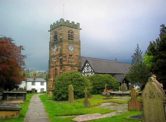
| DeskripsyonSt Oswald's Church, Lower Peover.jpg | Church at Lower Peover : The body of the church with its black and white timbering dates from the 14th century. The Perpendicular stone tower is a later addition, built in 1582. |
| Petsa | |
| Gigikanan | https://www.geograph.org.uk/photo/227384 |
| Tagsulat | Stephen Nunney |

|
This image was taken from the Geograph project collection. See this photograph's page on the Geograph website for the photographer's contact details. The copyright on this image is owned by Stephen Nunney and is licensed for reuse under the Creative Commons Attribution-ShareAlike 2.0 license.
|
This file is licensed under the Creative Commons Attribution-Share Alike 2.0 Generic license.
Attribution: Stephen Nunney
- Libre ka:
- sa pagsabwag – sa pagkopya, pag-apod-apod ug pagsabwag sa hinimo
- sa pag-remix – sa pag-adap sa binuhat
- Ubos sa mosunod nga mga kondisyon:
- atribusyon – Kinahanglan nimo nga hatagan ang angay nga kredito, maghatag usa ka link sa lisensya, ug ipakita kung adunay mga pagbag-o. Mahimo nimo kini buhaton sa bisan unsang makatarunganon nga paagi, apan dili sa bisan unsang paagi nga nagsugyot nga gi-endorso ka sa licensor o ang imong paggamit.
- share parehas – Kung imong gi-remix, gibag-o, o gibase sa materyal, kinahanglan nimo nga iapod-apod ang imong mga kontribusyon sa ilawom sa parehas o katugma nga lisensya sama sa orihinal.
Captions
Add a one-line explanation of what this file represents
Items portrayed in this file
depicts English
St Oswald's Church English
copyright status English
copyrighted English
coordinates of the point of view English
53°16'0.73"N, 2°23'1.61"W
Mayo 2003
Kaagi sa payl
I-klik ang petsa/oras aron makit-an ang hulagway sa payl niadtong panahona.
| Petsa/Takna | Thumbnail | Mga dimensyon | Tiggamit | Komento | |
|---|---|---|---|---|---|
| kasamtangan | 20:00, 20 Agosto 2007 | | 640 × 470 (77 KB) | Peter I. Vardy | {{Information |Description=Photograph |Source=http://www.geograph.org.uk/photo/227384 |Date=May 2003 |Author=Stephen Nunney |Permission= |other_versions= }} {{Geograph}} Category:Anglican churches Category:Churches in Cheshire [[Category:Grade I l |
Mga paggamit sa payl
Ang mosunod nga mga panid misumpay niining payl:
Global nga paggamit sa payl
Kining ubang wiki naggamit ning maong payl:
- Paggamit sa dag.wikipedia.org
- Paggamit sa de.wikipedia.org
- Paggamit sa en.wikipedia.org
- Paggamit sa fr.wikipedia.org
- Paggamit sa www.wikidata.org