Payl:Map_of_Kiribati_CIA_WFB.png
From Wikipedia, the free encyclopedia
Map_of_Kiribati_CIA_WFB.png (325 × 350 pixels, size sa payl: 9 KB, MIME type: image/png)
Kining maong payl gikan sa Wikimedia Commons ug mahimong gigamit sa ubang proyekto. Ang deskripsyon niini didto gipakita sa ubos.

|
This map image could be re-created using vector graphics as an SVG file. This has several advantages; see Commons:Media for cleanup for more information. If an SVG form of this image is available, please upload it and afterwards replace this template with
{{vector version available|new image name}}.
It is recommended to name the SVG file “Map of Kiribati CIA WFB.svg”—then the template Vector version available (or Vva) does not need the new image name parameter. |
Mubong sugid:
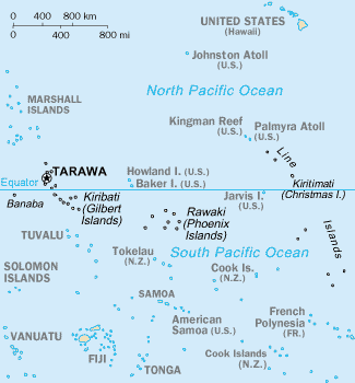
CIA-WF map of Kiribati
Pagtugot
| Public domainPublic domainfalsefalse |
This image is in the public domain because it contains materials that originally came from the United States Central Intelligence Agency's World Factbook.
Bahasa Indonesia ∙ čeština ∙ Deutsch ∙ eesti ∙ English ∙ español ∙ Esperanto ∙ français ∙ galego ∙ hrvatski ∙ italiano ∙ Nederlands ∙ norsk nynorsk ∙ polski ∙ português ∙ sicilianu ∙ slovenščina ∙ suomi ∙ Türkçe ∙ Zazaki ∙ беларуская (тарашкевіца) ∙ македонски ∙ русский ∙ српски / srpski ∙ українська ∙ ქართული ∙ বাংলা ∙ தமிழ் ∙ മലയാളം ∙ 한국어 ∙ 日本語 ∙ 中文 ∙ 中文(简体) ∙ 中文(繁體) ∙ العربية ∙ +/− |
 |
Captions
Items portrayed in this file
depicts English
media type English
image/png
Kaagi sa payl
I-klik ang petsa/oras aron makit-an ang hulagway sa payl niadtong panahona.
| Petsa/Takna | Thumbnail | Mga dimensyon | Tiggamit | Komento | |
|---|---|---|---|---|---|
| kasamtangan | 15:35, 17 Septiyembre 2010 | | 325 × 350 (9 KB) | Ras67 | cropped |
| 09:15, 27 Marso 2005 |  | 330 × 354 (10 KB) | Wolfman~commonswiki | {{CIA-map}} |
Mga paggamit sa payl
Ang mosunod nga mga panid misumpay niining payl:
Global nga paggamit sa payl
Kining ubang wiki naggamit ning maong payl:
- Paggamit sa af.wikipedia.org
- Paggamit sa avk.wikipedia.org
- Paggamit sa azb.wikipedia.org
- Paggamit sa ban.wikipedia.org
- Paggamit sa bjn.wikipedia.org
- Paggamit sa br.wikipedia.org
- Paggamit sa bs.wikipedia.org
- Paggamit sa cs.wikipedia.org
- Paggamit sa da.wikipedia.org
- Paggamit sa de.wikivoyage.org
- Paggamit sa en.wikipedia.org
- Howland Island
- Jarvis Island
- Line Islands
- Tabuaeran
- List of towns and villages in Kiribati
- Lists of hospitals in Oceania
- Talk:List of sovereign states and dependent territories in Oceania
- List of airports in Kiribati
- Wikipedia:Featured picture candidates/February-2007
- Wikipedia:Featured picture candidates/Kingman Reef
- Outline of Kiribati
- Wikipedia:Graphics Lab/Image workshop/Archive/Nov 2008
- Ministry of Line and Phoenix Islands Development
- Paggamit sa en.wikisource.org
- Paggamit sa en.wikiversity.org
- Paggamit sa eo.wikipedia.org
- Paggamit sa es.wikipedia.org
- Paggamit sa et.wikipedia.org
- Paggamit sa eu.wikipedia.org
- Paggamit sa fa.wikipedia.org
- Paggamit sa fi.wikipedia.org
View more global usage of this file.