Payl:Lake_sakakawea.jpg
From Wikipedia, the free encyclopedia
Tibuok resolusyon (3,904 × 3,856 pixels, size sa payl: 6.91 MB, MIME type: image/jpeg)
Kining maong payl gikan sa Wikimedia Commons ug mahimong gigamit sa ubang proyekto. Ang deskripsyon niini didto gipakita sa ubos.
Mubong sugid:
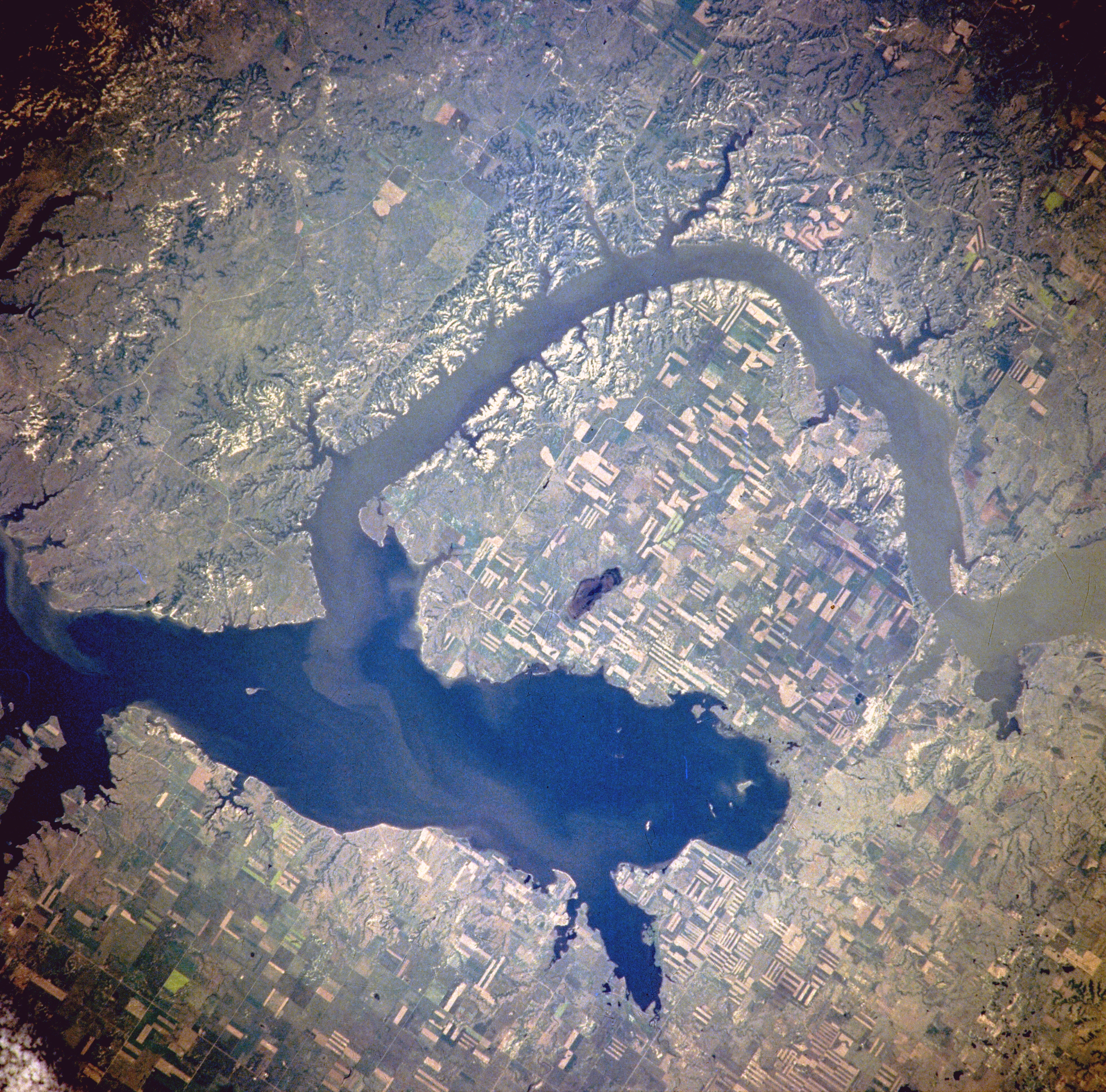
| DeskripsyonLake sakakawea.jpg |
Van Hook Arm of Lake Sakakawea, North Dakota, United States - Satellite image, July 1996 The image description can be found here. The bridge on the right holds North Dakota Highway 23. North is to the right side of the image.[1] |
| Petsa | |
| Gigikanan | http://eol.jsc.nasa.gov/sseop/EFS/photoinfo.pl?PHOTO=NM21-765-97 |
| Tagsulat | NASA |
| Pagtugot (Paggamit pag-usab niini nga file) |
PD-LAYOUT; PD-USGOV-NASA. |
Pagtugot
| Public domainPublic domainfalsefalse |
| This file is in the public domain in the United States because it was solely created by NASA. NASA copyright policy states that "NASA material is not protected by copyright unless noted". (See Template:PD-USGov, NASA copyright policy page or JPL Image Use Policy.) | ||
 |
Warnings:
|
Original upload log
(All user names refer to en.wikipedia)
- 2005-08-06 21:16 Darwinek 639×632×8 (196210 bytes)
Originally from en.wikipedia; description page is/was here.
Captions
Items portrayed in this file
depicts English
3 Hulyo 1996
Kaagi sa payl
I-klik ang petsa/oras aron makit-an ang hulagway sa payl niadtong panahona.
| Petsa/Takna | Thumbnail | Mga dimensyon | Tiggamit | Komento | |
|---|---|---|---|---|---|
| kasamtangan | 18:31, 27 Pebrero 2012 | | 3,904 × 3,856 (6.91 MB) | Ras67 | high resolution |
| 13:41, 4 Agosto 2007 |  | 639 × 632 (192 KB) | Matthiasb | {{Information |Description=Van Hook Arm of Lake Sakakawea, North Dakota, United States - July 1996 The image description can be found [http://eol.jsc.nasa.gov/sseop/EFS/photoinfo.pl?PHOTO=NM21-765-97 here]. North is to the right side of the image.[http: |
Mga paggamit sa payl
Ang mosunod nga 2 panid misumpay niining payl:
Global nga paggamit sa payl
Kining ubang wiki naggamit ning maong payl:
- Paggamit sa azb.wikipedia.org
- Paggamit sa de.wikipedia.org
- Paggamit sa en.wikipedia.org
- Paggamit sa es.wikipedia.org
- Paggamit sa fa.wikipedia.org
- Paggamit sa fr.wikipedia.org
- Paggamit sa it.wikipedia.org
- Paggamit sa ru.wikipedia.org
- Paggamit sa sr.wikipedia.org
- Paggamit sa te.wikipedia.org
- Paggamit sa www.wikidata.org
- Paggamit sa zh.wikipedia.org
Metadata
Ang kining payl adunay dugang nga impormasyon, mahimong nadugang gikan sa digital camera o scanner nga gigamit sa paghimo o pag-digitize niini.
Kon ang payl namodipikar gikan sa orihinal nga estado, ang ubang detalye mamahimong dili moreplek sa namodipikar nga payl.
| Image title | Van Hook Arm of Lake Sakakawea, North Dakota, U.S.A. Winter 1995-1996. The Van Hook Arm of Lake Sakakawea, within the Fort Berthold Indian Reservation, is featured in this spectacular, west-southwest-looking, low-oblique photograph. The Missouri River waters impounded by Garrison Dam, completed in 1956, (not in photograph) formed Lake Sakakawea [200 miles (322 kilometers) long] in western North Dakota. |
|---|---|
| Camera manufacturer | Lake Sakakawea |
| Camera model | NASA |
| Author | NASA |
| Copyright holder | http://eol.jsc.nasa.gov/sseop/EFS/photoinfo.pl?PHOTO=NM21-765-97 |
| Date and time of data generation | Winter 1995-1996 |
| User comments | NM21-765-097 |
| Orientation | Normal |
| Horizontal resolution | 72 dpi |
| Vertical resolution | 72 dpi |
| Software used | Adobe Photoshop |
| File change date and time | 19:08, 27 Pebrero 2012 |
| Color space | sRGB |