File:JAPAN_EARTHQUAKE_20110311-rm.png
From Wikipedia, the free encyclopedia
Gidak-on ning maong paunang tan-aw: 671 x 600 ka mga piksel. Uban pang mga resoluyon: 269 x 240 ka mga piksel | 537 x 480 ka mga piksel | 874 x 781 ka mga piksel.
Tibuok resolusyon (874 × 781 pixels, size sa payl: 255 KB, MIME type: image/png)
Kining maong payl gikan sa Wikimedia Commons ug mahimong gigamit sa ubang proyekto. Ang deskripsyon niini didto gipakita sa ubos.
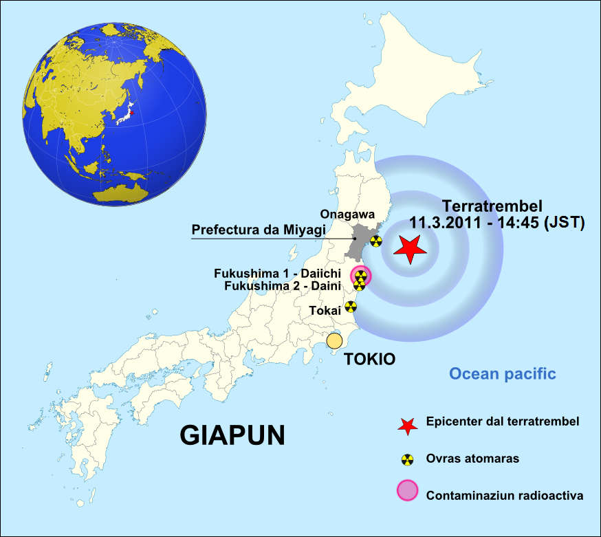
| DeskripsyonJAPAN EARTHQUAKE 20110311-rm.png | GIAPUN / Terratrembel / 2011-03-11 |
| Petsa | (UTC) |
| Gigikanan | |
| Tagsulat | |
| Other versions | • english version • german version • česká verze • español version |
.svg)
| This is a retouched picture, which means that it has been digitally altered from its original version. Modifications: GIAPUN / Terratrembel / 2011-03-11. The original can be viewed here: Japan location map with side map of the Ryukyu Islands.svg:
|
I, the copyright holder of this work, hereby publish it under the following licenses:
This file is licensed under the Creative Commons Attribution-Share Alike 3.0 Unported license.
- Libre ka:
- sa pagsabwag – sa pagkopya, pag-apod-apod ug pagsabwag sa hinimo
- sa pag-remix – sa pag-adap sa binuhat
- Ubos sa mosunod nga mga kondisyon:
- atribusyon – Kinahanglan nimo nga hatagan ang angay nga kredito, maghatag usa ka link sa lisensya, ug ipakita kung adunay mga pagbag-o. Mahimo nimo kini buhaton sa bisan unsang makatarunganon nga paagi, apan dili sa bisan unsang paagi nga nagsugyot nga gi-endorso ka sa licensor o ang imong paggamit.
- share parehas – Kung imong gi-remix, gibag-o, o gibase sa materyal, kinahanglan nimo nga iapod-apod ang imong mga kontribusyon sa ilawom sa parehas o katugma nga lisensya sama sa orihinal.

|
Gitugot ang pagkopya, pag-apud-apod o/ug pag-usab ning maong dokumento ubos sa mga termino sa GNU Free Documentation License, Version 1.2 o mas bag-ong bersiyon nga gimantala sa Free Software Foundation; nga walay Invariant Sections, walay Front-Cover Texts, ug walay Back-Cover Texts. Ang kopya sa lisensiya gilakip sa bahin nga giulohang GNU Free Documentation License.http://www.gnu.org/copyleft/fdl.htmlGFDLGNU Free Documentation Licensetruetrue |
You may select the license of your choice.
Original upload log
This image is a derivative work of the following images:
- File:Japan_location_map_with_side_map_of_the_Ryukyu_Islands.svg licensed with Cc-by-sa-3.0, GFDL
- 2010-10-30T13:53:18Z NordNordWest 413x373 (948276 Bytes) Liancourts Rock boundary
- 2010-09-17T01:15:53Z Dinamik 413x373 (1638123 Bytes) medium color for disputed territories
- 2010-03-21T11:41:34Z Chumwa 413x373 (1597074 Bytes) Präfekturgrenzen bereinigt
- 2010-03-20T13:33:30Z Chumwa 413x373 (1793386 Bytes) Trennlinie zu Nebenkarte etwas verbreitert
- 2010-03-20T09:50:05Z Chumwa 413x373 (2010954 Bytes) == {{int:filedesc}} == {{Information |Description= {{de|Postionskarte von [[:de:Japan|Japan]]}} Quadratische Plattkarte. Bei Nutzung der Hauptkarte mit den Hauptinseln gelten folgende geographische Begrenzungen für die (Ges
Uploaded with derivativeFX
Captions
Add a one-line explanation of what this file represents
Items portrayed in this file
depicts English
copyright status English
copyrighted English
17 Marso 2011
Kaagi sa payl
I-klik ang petsa/oras aron makit-an ang hulagway sa payl niadtong panahona.
| Petsa/Takna | Thumbnail | Mga dimensyon | Tiggamit | Komento | |
|---|---|---|---|---|---|
| kasamtangan | 01:06, 3 Abril 2011 | | 874 × 781 (255 KB) | Obankston | corrected timezone |
| 01:01, 3 Abril 2011 |  | 874 × 781 (159 KB) | Obankston | Reverted to version as of 19:39, 17 March 2011 | |
| 00:59, 3 Abril 2011 |  | 874 × 781 (255 KB) | Obankston | corrected timezone | |
| 12:18, 19 Marso 2011 |  | 874 × 781 (203 KB) | W.Rebel | update globe | |
| 19:39, 17 Marso 2011 |  | 874 × 781 (159 KB) | W.Rebel | {{Information |Description=GIAPUN / Terratrembel / 2011-03-11 |Source=*File:Japan_location_map_with_side_map_of_the_Ryukyu_Islands.svg |Date=2011-03-17 19:38 (UTC) |Author=*File:Japan_location_map_with_side_map_of_the_Ryukyu_Islands.svg: [[:de |
Mga paggamit sa payl
There are no pages that use this file.
Gikuha gikan sa "https://ceb.wikipedia.org/wiki/Payl:JAPAN_EARTHQUAKE_20110311-rm.png"