Fitxer:Europe20000ya.png
From Wikipedia, the free encyclopedia
Fitxer original (1.900 × 1.264 píxels, mida del fitxer: 98 Ko, tipus MIME: image/png)
| Aquest fitxer i la informació mostrada a continuació provenen del dipòsit multimèdia lliure Wikimedia Commons. |
Resum
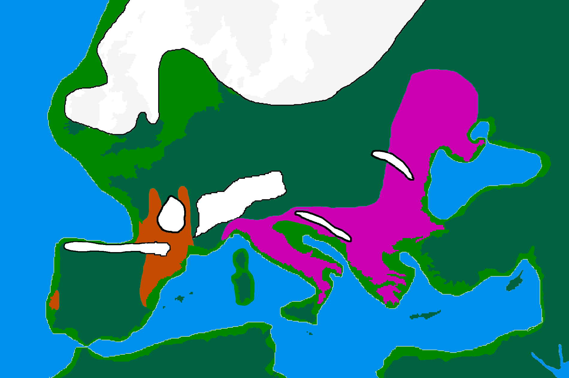
| DescripcióEurope20000ya.png | map of Europe 20,000 years ago. |
| Data | |
| Font |
made by me from Image:BlankMap-Europe-v3.png, which is GFDL v1.2, outline of ancient coast and extent of ice added by me from information from "After the Ice: A Global History" by Steve Mithen. Information about human refugia from "Origins of the British" by Stephen Oppenheimer and "Out of Eden by Stephen Oppenheimer. These were sketched in by me from information supplied by these books. Coloured areas are the furthest extent of the cultures between 15 kya and 20 kya. |
| Autor | User:Wobble |
| Permís (Com reutilitzar aquest fitxer) |
GFDL |
Llicència

|
S'autoritza la còpia, la distribució i la modificació d'aquest document sota els termes de la llicència de documentació lliure GNU versió 1.2 o qualsevol altra versió posterior que publiqui la Free Software Foundation; sense seccions invariants, ni textos de portada, ni textos de contraportada. S'inclou una còpia d'aquesta llicència en la secció titulada GNU Free Documentation License.http://www.gnu.org/copyleft/fdl.htmlGFDLGNU Free Documentation Licensetruetrue |
| Aquest fitxer està subjecte a la llicència de Creative Commons Reconeixement i Compartir Igual 3.0 No adaptada. | ||
| ||
| Aquest avís de llicència s'ha afegit a aquest fitxer d'acord amb l'actualització de la llicència GFDL.http://creativecommons.org/licenses/by-sa/3.0/CC BY-SA 3.0Creative Commons Attribution-Share Alike 3.0truetrue |
Llegendes
Elements representats en aquest fitxer
representa l'entitat
25 feb 2007
image/png
100.032 byte
1.264 píxel
1.900 píxel
5c60df30a6e10ed8a806aaeb1f5b78ab633878b8
Historial del fitxer
Cliqueu una data/hora per veure el fitxer tal com era aleshores.
| Data/hora | Miniatura | Dimensions | Usuari/a | Comentari | |
|---|---|---|---|---|---|
| actual | 18:00, 12 abr 2007 | | 1.900 × 1.264 (98 Ko) | Wobble | Reverted to earlier revision |
| 17:59, 12 abr 2007 |  | 1.000 × 665 (106 Ko) | Wobble | Reverted to earlier revision | |
| 17:50, 12 abr 2007 |  | 1.900 × 1.264 (98 Ko) | Wobble | better version, shows refugia better, from Oppenheimer, Out of Eden | |
| 10:13, 28 març 2007 |  | 1.000 × 665 (106 Ko) | Dbachmann | shrunk; accounting for Black Sea flood. | |
| 20:59, 25 feb 2007 |  | 1.900 × 1.264 (129 Ko) | Wobble | {{Information |Description=map of Europe 20,000 years ago. |Source=made from Image:BlankMap-Europe-v3.png, which is GFDL v1.2 by me, outline of coast and extent of ice added by me from information from "After the Ice: A GLoba History" by Steve Mithen. |
Ús del fitxer
Les 4 pàgines següents utilitzen aquest fitxer:
Ús global del fitxer
Utilització d'aquest fitxer en altres wikis:
- Utilització a ar.wikipedia.org
- Utilització a bs.wikipedia.org
- Utilització a cs.wikipedia.org
- Utilització a de.wikipedia.org
- Utilització a en.wikipedia.org
- Europe
- River Thames
- Upper Paleolithic
- Last Glacial Maximum
- Refugium (population biology)
- User:Swid/Sandbox
- Haplogroup I-M170
- Genetic history of Europe
- Last Glacial Maximum refugia
- User:Hans Adler/Sandbox
- User:Wobble/images
- Cro-Magnon
- Epigravettian
- User:Bongan/genetic history of the human race
- Western hunter-gatherer
- User:Baum019/Last Glacial Maximum refugia
- Utilització a en.wikiversity.org
- Utilització a eo.wikipedia.org
- Utilització a es.wikipedia.org
- Utilització a eu.wikipedia.org
- Utilització a fa.wikipedia.org
- Utilització a fi.wikipedia.org
- Utilització a fr.wikipedia.org
- Utilització a it.wikipedia.org
- Utilització a ja.wikipedia.org
Vegeu més usos globals d'aquest fitxer.