Fitxer:1784_Bocage_Map_of_The_Bosphorus_and_the_City_of_Byzantium_-_Istanbul_-_Constantinople_-_Geographicus_-_Bosphorus-white-1793.jpg
From Wikipedia, the free encyclopedia
Mida d'aquesta previsualització: 800 × 544 píxels. Altres resolucions: 320 × 218 píxels | 640 × 436 píxels | 1.024 × 697 píxels | 1.280 × 871 píxels | 2.000 × 1.361 píxels.
Fitxer original (2.000 × 1.361 píxels, mida del fitxer: 665 Ko, tipus MIME: image/jpeg)
| Aquest fitxer i la informació mostrada a continuació provenen del dipòsit multimèdia lliure Wikimedia Commons. |
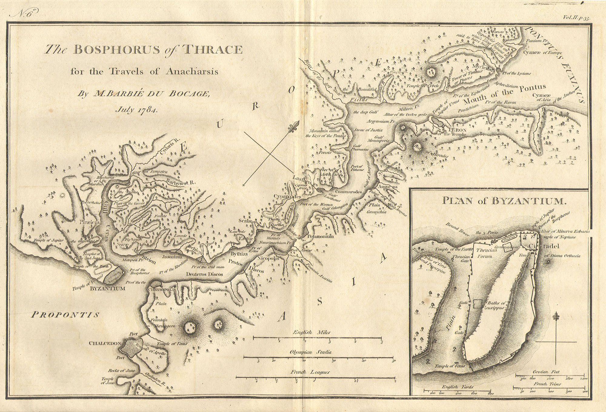
| Bosphorus and the city of Byzantium. | |||||||
|---|---|---|---|---|---|---|---|
| Artista | |||||||
| Títol |
Bosphorus and the city of Byzantium. |
||||||
| Descripció |
English: This lovely map, depicting the Bosphorus and the city of Byzantium, was prepared by Jean-Denis Barbié du Bocage in 1784 for the “Travels of Anarcharsis”. The map shows the narrow naval passage from the Propontis (Sea of Marmara) to the Pontus Euxinus (Black Sea). There is a beautiful inset plan of the Horn of Byzantium. Today Byzantium is Istanbul, but the horn and many of the ancient structures still exists. This map also shows the area in considerable topographical detail. |
||||||
| Data |
1784 date QS:P571,+1784-00-00T00:00:00Z/9 |
||||||
| Dimensions |
altura: 8,5 in (21,5 cm); amplada: 12 in (30,4 cm) dimensions QS:P2048,8.5U218593 dimensions QS:P2049,12U218593 |
||||||
| Número d'inventari |
Geographicus link: Bosphorus-white-1793 |
||||||
| Origen/Fotògraf |
|
||||||
| Permís (Com reutilitzar aquest fitxer) |
|
||||||
| Altres versions |
|
||||||

Llegendes
Afegeix una explicació d'una línia del que representa aquest fitxer
The Bosphorus and the city of Byzantium in the 4th century BCE, map drawn by Jean-Denis Barbié du Bocage in 1784 for the "Voyage of the young Anacharsis in Greece".
Le Bosphore et la ville de Byzance, carte dessinée par Jean-Denis Barbié du Bocage en 1784 pour le "Voyage du jeune Anacharsis en Grèce".
أعد هذه الخريطة الجميلة ، التي تصور مضيق البوسفور ومدينة بيزنطة ، جان دينيس باربي دو بوكاج في عام 1784 من أجل "رحلات Anarcharsis". تُظهر الخريطة الممر البحري الضيق من t
Elements representats en aquest fitxer
representa l'entitat
image/jpeg
fa5ae25f26f69d87f7f527c61171816723c8169e
681.401 byte
1.361 píxel
2.000 píxel
Historial del fitxer
Cliqueu una data/hora per veure el fitxer tal com era aleshores.
| Data/hora | Miniatura | Dimensions | Usuari/a | Comentari | |
|---|---|---|---|---|---|
| actual | 22:46, 15 març 2011 | | 2.000 × 1.361 (665 Ko) | BotMultichill | {{subst:User:Multichill/Geographicus |link=http://www.geographicus.com/P/AntiqueMap/Bosphorus-white-1793 |product_name=1784 Bocage Map of The Bosphorus and the City of Byzantium / Istanbul / Constantinople |map_title=Bosphorus and the city of Byzantium. | |
Ús del fitxer
La pàgina següent utilitza aquest fitxer:
Ús global del fitxer
Utilització d'aquest fitxer en altres wikis:
- Utilització a ar.wikipedia.org
- Utilització a arz.wikipedia.org
- Utilització a ast.wikipedia.org
- Utilització a az.wikipedia.org
- Utilització a cs.wikipedia.org
- Utilització a el.wikipedia.org
- Utilització a en.wikipedia.org
- Utilització a eo.wikipedia.org
- Utilització a eu.wikipedia.org
- Utilització a gl.wikipedia.org
- Utilització a he.wikivoyage.org
- Utilització a hu.wikipedia.org
- Utilització a hy.wikipedia.org
- Utilització a it.wikipedia.org
- Utilització a nap.wikipedia.org
- Utilització a pt.wikipedia.org
- Utilització a ro.wikipedia.org
- Utilització a sk.wikipedia.org
- Utilització a tr.wikipedia.org
- Utilització a www.wikidata.org
- Utilització a zh.wikipedia.org