File:Madrid-metro-map.png
From Wikipedia, the free encyclopedia
Fitxer original (1.000 × 1.420 píxels, mida del fitxer: 204 Ko, tipus MIME: image/png)
| Aquest fitxer i la informació mostrada a continuació provenen del dipòsit multimèdia lliure Wikimedia Commons. |


|
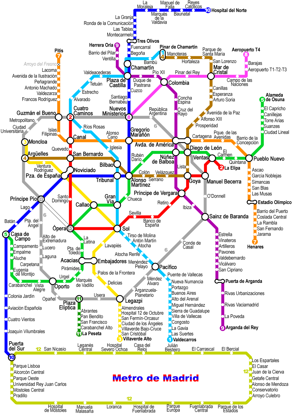
Improved version of the previous Madrid metro map, also by Montrealais. Versión amejorada del plano anterior del metro de Madrid, igualmente por Montrealais.
- Sou lliure de:
- compartir – copiar, distribuir i comunicar públicament l'obra
- adaptar – fer-ne obres derivades
- Amb les condicions següents:
- reconeixement – Heu de donar la informació adequada sobre l'autor, proporcionar un enllaç a la llicència i indicar si s'han realitzat canvis. Podeu fer-ho amb qualsevol mitjà raonable, però de cap manera no suggereixi que l'autor us dóna suport o aprova l'ús que en feu.
- compartir igual – Si modifiqueu, transformeu, o generareu amb el material, haureu de distribuir les vostres contribucions sota una llicència similar o una de compatible com l'original
Other versions
| Anotacions InfoField | Aquesta imatge té anotacions: Vegeu-les a Commons |
Эти остановки закрыты на вечер
Llegendes
Elements representats en aquest fitxer
representa l'entitat
208.406 byte
1.420 píxel
1.000 píxel
image/png
058dd990787e710d74ff00d400e253ba395d17f5
Historial del fitxer
Cliqueu una data/hora per veure el fitxer tal com era aleshores.
| Data/hora | Miniatura | Dimensions | Usuari/a | Comentari | |
|---|---|---|---|---|---|
| actual | 17:20, 24 feb 2010 | | 1.000 × 1.420 (204 Ko) | Dcoetzee | Remove visible watermark with copyright, attribution, disclaimer |
| 22:32, 13 gen 2008 |  | 1.000 × 1.420 (208 Ko) | Mahahahaneapneap | pngcrushed | |
| 16:23, 25 maig 2007 |  | 1.000 × 1.420 (316 Ko) | Montrealais | {{Information |Description=Madrid metro map updated to 25 May 2007 |Source=self-made |Date=25 May 2007 |Author= User:Montrealais }} | |
| 08:48, 12 abr 2007 |  | 1.000 × 1.280 (281 Ko) | Montrealais | update | |
| 21:11, 5 abr 2007 |  | 1.000 × 1.280 (277 Ko) | Montrealais | update - line 1 to Chamartín. | |
| 00:16, 30 març 2007 |  | 1.000 × 1.280 (275 Ko) | Montrealais | updated to March 2007 | |
| 16:14, 22 des 2006 |  | 1.000 × 1.280 (174 Ko) | Mahahahaneapneap | pngcrushed | |
| 23:38, 30 ago 2006 |  | 1.000 × 1.280 (265 Ko) | Montrealais | {{Information |Description=Map of the w:Madrid Metro - improved version of previous by same author. Plano del w:es:Metro de Madrid; versión amejorada de la previa por el mismo autor. |Source=Own work; licensed version of a map created for my we | |
| 16:10, 15 gen 2005 |  | 800 × 1.483 (107 Ko) | Jcornelius | Madrid metro map. Version of a map I drew that will eventually appear on my website, http://www.metrodemontreal.com/ . Drawn by Montrealais {{GFDL]] |
Ús del fitxer
No hi ha pàgines que utilitzin aquest fitxer.
Ús global del fitxer
Utilització d'aquest fitxer en altres wikis:
- Utilització a de.wikivoyage.org
- Utilització a en.wikipedia.org
- User:Montrealais/Metro maps
- Template:Pic of the day/Archive1
- Wikipedia:Featured picture candidates/May-2004
- Wikipedia:Picture of the day/July 2004
- Wikipedia:Picture of the day/May 2005
- Wikipedia:POTD/May 15, 2005
- Wikipedia:Picture of the day/May 15, 2005
- Portal talk:Spain
- User:Cyde/Featured pictures
- Portal:Maps/Selected picture
- Wikipedia:Featured picture candidates/delist/2007
- Wikipedia:Featured picture candidates/delist/Image:Madrid-metro-map.png
- User:Conservativegbd
- Portal:Maps/Selected picture/26
- Wikipedia:Graphics Lab/Resources/Draw topological maps
- Wikipedia talk:WikiProject Spain/Archive 7
- Wikipedia:Featured picture candidates/delist/2010
- Wikipedia:Featured picture candidates/delist/File:Madrid-metro-map.png
- Template:POTD/2004-07-07
- Utilització a fr.wikipedia.org
- Utilització a hu.wikipedia.org
- Utilització a pl.wikipedia.org
- Utilització a ru.wikipedia.org
Metadades
Aquest fitxer conté informació addicional, probablement afegida per la càmera digital o l'escàner utilitzat per a crear-lo o digitalitzar-lo. Si s'ha modificat posteriorment, alguns detalls poden no reflectir les dades reals del fitxer modificat.
| Resolució horitzontal | 39,37 ppc |
|---|---|
| Resolució vertical | 39,37 ppc |