Cliqueu una data/hora per veure el fitxer tal com era aleshores.
| Data/hora | Miniatura | Dimensions | Usuari/a | Comentari |
|---|
| actual | 11:05, 8 nov 2021 |  | 1.200 × 526 (206 Ko) | Randomastwritter | jubaland |
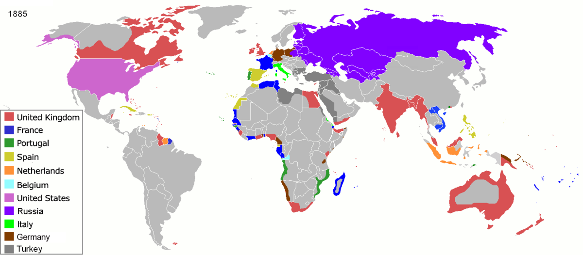
| 11:52, 5 abr 2020 |  | 1.200 × 526 (206 Ko) | Ориенталист | South Sakhalin was part of Russia in 1885 |
| 13:17, 2 maig 2015 |  | 1.425 × 625 (49 Ko) | Chrischerf | German Empire and colonies in 1885; Sudan under control of the Mahdi |
| 04:57, 3 ago 2014 |  | 1.425 × 625 (54 Ko) | Alvin Lee | correcting the boundaries of Russia and China |
| 15:54, 3 nov 2013 |  | 1.425 × 625 (78 Ko) | McZusatz | Reverted to version as of 00:22, 24 January 2011 [corrupt file?] |
| 17:24, 3 nov 2012 |  | 1.425 × 625 (67 Ko) | Franco310397 | Spanish presence in Micronesia (Oceania) included in the Captaincy General of the Philippines. In the Caroline Islands and the Mariana Islands. |
| 02:22, 24 gen 2011 |  | 1.425 × 625 (78 Ko) | Micsha~commonswiki | Reverted to version as of 02:17, 3 May 2010 |
| 02:22, 24 gen 2011 |  | 506 × 326 (85 Ko) | Micsha~commonswiki | Only Africa; includes map key |
| 04:17, 3 maig 2010 |  | 1.425 × 625 (78 Ko) | Kieran4 | slight edit |
| 04:14, 3 maig 2010 |  | 1.425 × 625 (78 Ko) | Kieran4 | Correct Dutch East INdies |
No hi ha pàgines que utilitzin aquest fitxer.
Utilització d'aquest fitxer en altres wikis:
- Utilització a am.wikipedia.org
- Utilització a de.wikipedia.org
- Utilització a en.wikipedia.org
- Utilització a es.wikipedia.org
- Utilització a fr.wikipedia.org
- Utilització a he.wikipedia.org
- Utilització a oc.wikipedia.org
- Utilització a sk.wikipedia.org
Aquest fitxer conté informació addicional, probablement afegida per la càmera digital o l'escàner utilitzat per a crear-lo o digitalitzar-lo. Si s'ha modificat posteriorment, alguns detalls poden no reflectir les dades reals del fitxer modificat.
.jpg)
._LOC_2001620596.jpg)


