Datoteka:Österreich_-_NUTS1,_NUTS2,_NUTS3.png
From Wikipedia, the free encyclopedia
Veličina ovog prikaza: 733 × 600 piksela. Ostale rezolucije: 293 × 240 piksela | 587 × 480 piksela | 939 × 768 piksela | 1.252 × 1.024 piksela | 2.200 × 1.800 piksela.
Izvorna datoteka (2.200 × 1.800 piksela, veličina datoteke: 541 KB, MIME tip: image/png)
| Ova datoteka je s Wikimedia Commonsa. Opis s njene stranice opisa datoteke prikazan je ispod. Commons je skladište slobodnih medija i datoteka za sve projekte fondacije Wikimedia. Možete i Vi pomoći. |

|
This locator map image could be re-created using vector graphics as an SVG file. This has several advantages; see Commons:Media for cleanup for more information. If an SVG form of this image is available, please upload it and afterwards replace this template with
{{vector version available|new image name}}.
It is recommended to name the SVG file “Österreich - NUTS1, NUTS2, NUTS3.svg”—then the template Vector version available (or Vva) does not need the new image name parameter. |
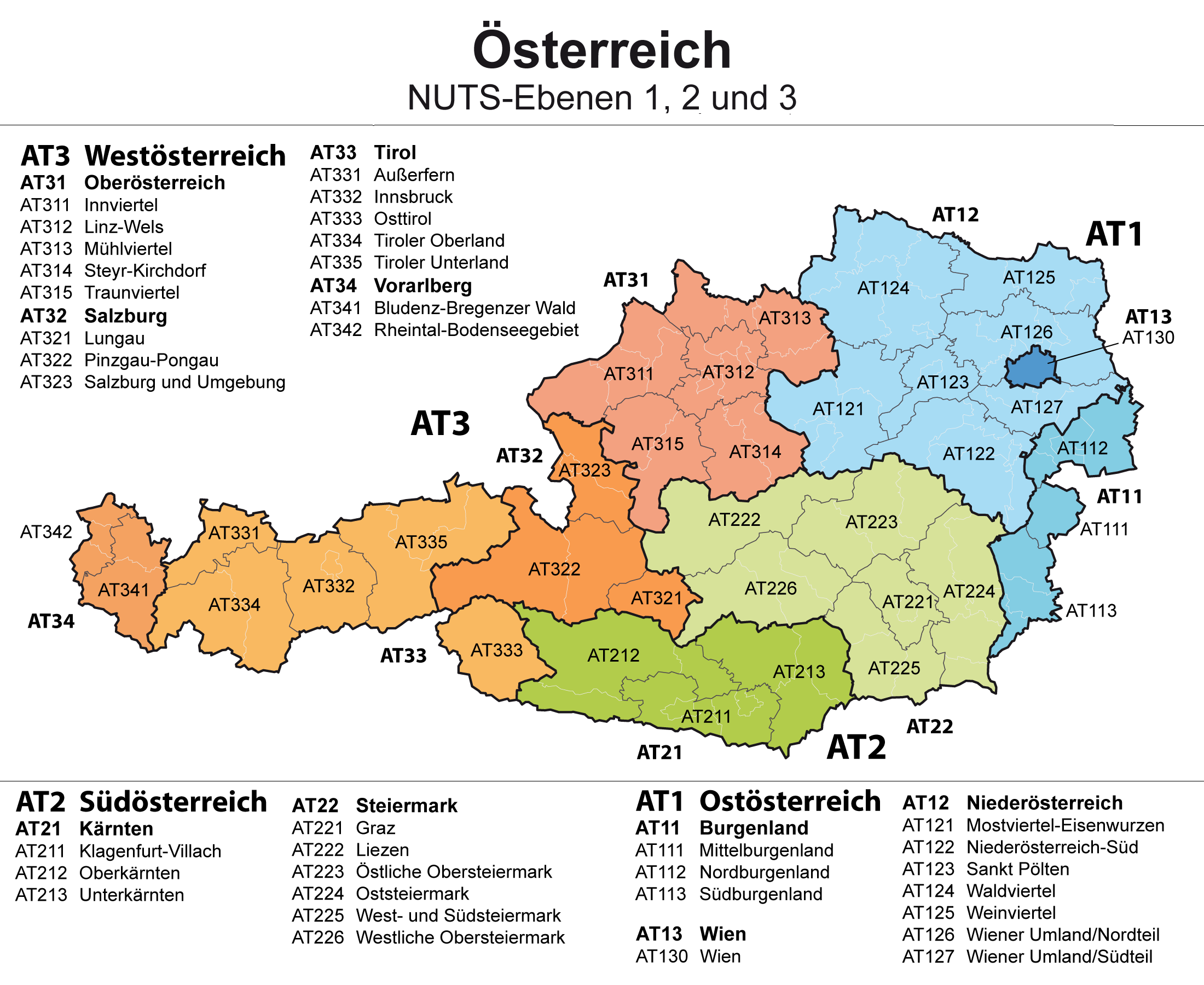
| OpisÖsterreich - NUTS1, NUTS2, NUTS3.png |
Deutsch: Karte von Österreich: NUTS-Raumeinheiten auf den Ebenen NUTS1, NUTS2 und NUTS3 mit den Grenzen der politischen Bezirke im Hintergrund
English: Map of Austria: NUTS regions on level NUTS1, NUTS2 and NUTS3 |
| Datum | |
| Izvor | Vlastito djelo |
| Autor | Maximilian Dörrbecker (Chumwa) |
| Dopuštenje (Naknadno korištenje ove datoteke) |
Ja, vlasnik autorskog prava ovog djela, ovdje ga objavljujem pod sljedećom licencom: Ova datoteka je licencirana pod Creative Commons Attribution-Share Alike 2.5 generičkom licencom.
Sie dürfen das Bild zu den folgenden Bedingungen nutzen:
|
Captions
Add a one-line explanation of what this file represents
Items portrayed in this file
prikazuje
source of file engleski
original creation by uploader engleski
maj 2009
Historija datoteke
Kliknite na datum/vrijeme da vidite verziju datoteke iz tog vremena.
| Datum/vrijeme | Smanjeni pregled | Dimenzije | Korisnik | Komentar | |
|---|---|---|---|---|---|
| trenutno | 22:53, 23 maj 2015 | | 2.200 × 1.800 (541 KB) | Kontrollstellekundl | cropped |
| 10:22, 9 juli 2009 |  | 2.650 × 1.725 (522 KB) | Chumwa | AT23 in AT32 korrigiert | |
| 07:47, 15 maj 2009 |  | 3.975 × 2.587 (531 KB) | Chumwa | {{Information |Description= *{{ de }} Karte von Österreich: NUTS-Raumeinheiten auf den Ebenen NUTS1 und NUTS2 mit den Grenzen der politischen Bezirke im Hintergrund *{{ en }} Map of Germany: NUTS regions on level NUTS1, NUTS2 and NUTS3 |Source=Self made |
Upotreba datoteke
Sljedeća stranica koristi ovu datoteku:
Globalna upotreba datoteke
Sljedeći wikiji koriste ovu datoteku:
- Upotreba na az.wikipedia.org
- Upotreba na bar.wikipedia.org
- Upotreba na de.wikipedia.org
- Upotreba na ru.wikipedia.org
- Upotreba na tr.wikipedia.org
- Upotreba na uk.wikipedia.org
Metapodaci
Ova datoteka sadržava dodatne podatke koje je vjerovatno dodala digitalna kamera ili skener u procesu snimanja, odnosno digitalizacije. Ako je datoteka mijenjana, podaci možda nisu u skladu sa stvarnim stanjem.
| Horizontalna rezolucija | 78,74 dpc |
|---|---|
| Vertikalna rezolucija | 78,74 dpc |
| Korišteni softver |
|