File:Czechoslovakia_IV.png
From Wikipedia, the free encyclopedia
Ment ar rakweled-mañ : 800 × 364 piksel. pizhderioù all : 320 × 146 piksel | 640 × 291 piksel | 1 128 × 513 piksel.
Restr orin (1 128 × 513 piksel, ment ar restr : 130 Kio, seurt MIME : image/png)
![]()
| Tennet eo ar restr-mañ eus Wikimedia Commons ha gallout a ra bezañ implijet evit raktresoù all. Diskouezet eo deskrivadur he fajenn zeskrivañ amañ dindan. |
| DeskrivadurCzechoslovakia IV.png |
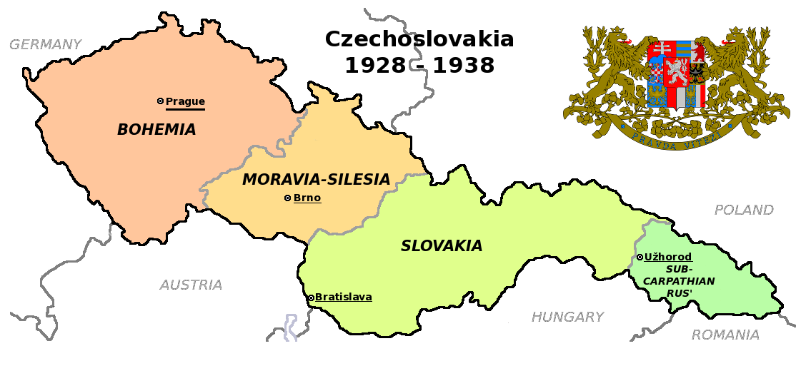
Čeština: Zemská mapa Československa v letech 1928 až 1938 s vyznačenými zemskými hlavními městy English: Maps of Czechoslovakia in 1928-1938 with marked borders of all four Czechoslovak lands and their regional capital cities |
| Deiziad | (UTC) |
| Mammenn | |
| Aozer |
|
| Stummoù all |
Derivative works of this file: |
| This is a retouched picture, which means that it has been digitally altered from its original version. Modifications: Simplified map. The original can be viewed here: Czechoslovakia COA large.svg:
|
Emañ ar restr-mañ dindan an aotre-implijout Creative Commons Deroadenn-Kenrannañ 3.0 Unported
- Gallout a rit :
- eskemm – eilañ, skignañ ha treuzkas an oberenn-mañ
- kemmañ – azasaat an oberenn-mañ
- diouzh ma heuilhit kement-mañ :
- deroadenn – Rankout a rit reiñ an titouroù perc'henniezh rekis diwar-benn an aozer, pourchas ul liamm war-zu an aotre-implijout ha merkañ hag-eñ ez eus bet graet kemmoù. Gallout a rit en ober en un doare reizh met hep lakaat da grediñ ez oc'h bet aprouet gantañ pe ez eo aprouet gantañ implij an oberenn-mañ.
- eskemmañ rik-ha-rik – Ma tegasit kemmoù, ma treuzfurmit pe ma savit un dra bennak diwar an oberenn-mañ e rankit skignañ an oberenn krouet ganeoc'h dindan an hevelep aotre-implijout pe un aotre-implijout kar-tost d'an hini orin.
Marilh orin ar pellgargadurioù
This image is a derivative work of the following images:
- File:Czechoslovakia01.png licensed with PD-self
- 2011-05-19T10:54:48Z PANONIAN 1128x513 (64020 Bytes) minor change, marked provincial capitals
- 2011-05-17T09:53:27Z PANONIAN 1128x513 (63994 Bytes) Reverted to version as of 10:38, 24 April 2011 - because this is map of Czechoslovakia and it was capital of Czechoslovakia
- 2011-05-17T05:07:38Z Millenium187 1128x513 (56086 Bytes) Why was Prague underlined and Vienna, Brno, Bratislava and other capital cities were not? -- corrected
- 2011-04-24T10:38:30Z PANONIAN 1128x513 (63994 Bytes) few corrections
- 2011-04-23T11:31:49Z PANONIAN 1128x509 (62348 Bytes) improved version
- 2008-12-20T20:58:14Z Kirk 1100x497 (80038 Bytes) {{Information |Description= |Source= |Date= |Author= |Permission= |other_versions= }}
- 2006-12-28T16:11:35Z Electionworld 1100x497 (92110 Bytes) {{ew|en|PANONIAN}} Map of {{link|Czechoslovakia}} (self made) Note: The provinces shown on the map were introduced by Act No. 125/1927 Zb. and became effective in 1928. {{PD-self}} [[Category:Maps of Czechoslovakia]] [[Cat
- File:Czechoslovakia_COA_large.svg licensed with Cc-by-sa-3.0-migrated, GFDL
- 2010-09-06T23:55:59Z Fry1989 635x350 (1316079 Bytes) Reverted to version as of 23:52, 6 September 2010 this version will have to stay, message me with any corrections you want and I'll see what I can do
- 2010-09-06T23:53:49Z Kwasura 635x350 (1440388 Bytes) correction
- 2010-09-06T23:52:33Z Fry1989 635x350 (1316079 Bytes) lets see if it'll upload for me, checks out fine in inkscape
- 2010-09-06T23:50:19Z Kwasura 635x350 (1440373 Bytes) correction
- 2010-08-12T19:52:16Z Delta 51 635x350 (1440480 Bytes) Reverted to version as of 08:13, 5 November 2006 (the new versions don't work at all)
- 2010-08-09T20:16:25Z Kwasura 635x350 (1026422 Bytes) trying
- 2010-08-09T20:06:57Z Kwasura 635x350 (1976 Bytes) well, I just don't know how to do it...
- 2010-08-09T20:05:24Z Kwasura 635x350 (1976 Bytes) one more try
- 2010-08-09T20:02:09Z Kwasura 635x350 (1976 Bytes) correction 2nd try
- 2010-08-09T19:57:24Z Kwasura 635x350 (1976 Bytes) correction
- 2006-11-05T08:13:30Z Happenstance 635x350 (1440480 Bytes) crowns for the eagles
- 2006-06-17T05:00:05Z Happenstance 635x350 (1439900 Bytes) ==Author:== * commons: [[user:Shazz|Shazz]] * pl.wiki: [[w:pl:user:Shazz|Shazz]] ==Description== * '''cs:''' Znak Československa - velký * '''pl:''' Godło Czechosłowacji - duże * '''en:''' Coat of Arms of Czechoslovakia
Uploaded with derivativeFX
Captions
Add a one-line explanation of what this file represents
Items portrayed in this file
diskouez a ra
12 Eos 2011
image/png
checksum saozneg
0f42dd9f663bd978c77df015ae75ea5cbbf1c016
133 226 byte
513 pixel
1 128 pixel
Istor ar restr
Klikañ war un deiziad/eur da welet ar restr evel ma oa da neuze.
| Deiziad/Eur | Munud | Mentoù | Implijer | Notenn | |
|---|---|---|---|---|---|
| red | 12 Eos 2011 da 18:36 | | 1 128 × 513 (130 Kio) | Millenium187 | {{Information |Description={{cs|Zemská mapa Československa v letech 1928 až 1938}} {{en|Maps of Czechoslovakia in 1928-1938 with marked borders of all four Czechoslovak countries}} |Source=*File:Czechoslovakia01.png *[[:File:Czechoslovakia_COA_l |
Implij ar restr
Pajenn ebet ne implij ar restr-mañ.
Implij hollek ar restr
Ober a ra ar wikioù da-heul gant ar restr-mañ :
- Implij war ca.wikipedia.org
- Implij war en.wikipedia.org
- Implij war fa.wikipedia.org
- Implij war fr.wikipedia.org
- Implij war ps.wikipedia.org
Adtapet diwar « https://br.wikipedia.org/wiki/Restr:Czechoslovakia_IV.png »