File:Cz-svk_granica.png
From Wikipedia, the free encyclopedia
N'haller ket gwellaat ar pizhder.
Cz-svk_granica.png (577 × 366 piksel, ment ar restr : 31 Kio, seurt MIME : image/png)
![]()
| Tennet eo ar restr-mañ eus Wikimedia Commons ha gallout a ra bezañ implijet evit raktresoù all. Diskouezet eo deskrivadur he fajenn zeskrivañ amañ dindan. |
| DeskrivadurCz-svk granica.png |
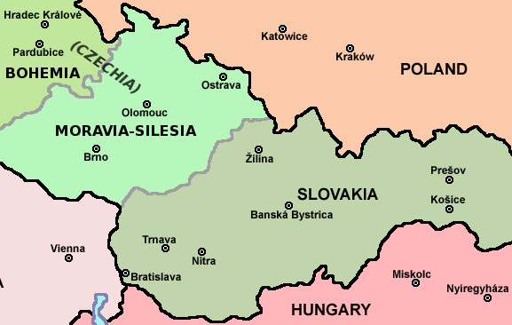
English: Map of Czech-Slovakia border |
| Deiziad | (UTC) |
| Mammenn | |
| Aozer |
|
| This is a retouched picture, which means that it has been digitally altered from its original version. Modifications: piece of file. The original can be viewed here: Czechoslovakia01.png:
|
Evel perc'henn eus ar gwirioù oberour, e embannan an oberenn-mañ dindan an aotre-implijout da-heul :
| Public domainPublic domainfalsefalse |
| Me, perc'henn war gwirioù an oberenn-mañ, a laka anezhi en domani foran. Talvezout a ra kement-mañ evit ar bed a-bezh. E broioù zo e c'hall kement-mañ bezañ dibosupl ent lezennel; mard emañ kont evel-se : Reiñ a ran aotre d'an holl da implijout an oberenn-mañ evit ober ne vern petra, hep tamm bevenn ebet estreget hini al lezenn. |
Marilh orin ar pellgargadurioù
This image is a derivative work of the following images:
- File:Czechoslovakia01.png licensed with PD-self
- 2011-04-24T10:38:30Z PANONIAN 1128x513 (63994 Bytes) few corrections
- 2011-04-23T11:31:49Z PANONIAN 1128x509 (62348 Bytes) improved version
- 2008-12-20T20:58:14Z Kirk 1100x497 (80038 Bytes) {{Information |Description= |Source= |Date= |Author= |Permission= |other_versions= }}
- 2006-12-28T16:11:35Z Electionworld 1100x497 (92110 Bytes) {{ew|en|PANONIAN}} Map of {{link|Czechoslovakia}} (self made) Note: The provinces shown on the map were introduced by Act No. 125/1927 Zb. and became effective in 1928. {{PD-self}} [[Category:Maps of Czechoslovakia]] [[Cat
Uploaded with derivativeFX
Captions
Add a one-line explanation of what this file represents
Items portrayed in this file
diskouez a ra
25 Ebr 2011
image/png
checksum saozneg
07afaaed2827aa098bfdfe0f97b9d6bd5ad92abc
31 517 byte
366 pixel
577 pixel
Istor ar restr
Klikañ war un deiziad/eur da welet ar restr evel ma oa da neuze.
| Deiziad/Eur | Munud | Mentoù | Implijer | Notenn | |
|---|---|---|---|---|---|
| red | 12 Eos 2011 da 17:26 | | 577 × 366 (31 Kio) | Millenium187 | There was a quite significant flaw, today's Czech republic consists of three historical countries: Bohemia, Moravia and Czech Silesia, each of them has its own coat of arms, flag, history, etc. Moravia is not in Bohemia, it's like to say that Scotland is |
| 25 Ebr 2011 da 09:19 |  | 577 × 366 (22 Kio) | Mixx321 | dr | |
| 25 Ebr 2011 da 09:17 |  | 577 × 366 (23 Kio) | Mixx321 | {{Information |Description=* '''English:''' Map of Czech-Slovakia border |Source=*File:Czechoslovakia01.png |Date=2011-04-25 09:15 (UTC) |Author=*File:Czechoslovakia01.png: Electionworld *derivative work: ~~~ |Permission |
Implij ar restr
Pajenn ebet ne implij ar restr-mañ.
Implij hollek ar restr
Ober a ra ar wikioù da-heul gant ar restr-mañ :
- Implij war pl.wikipedia.org
Adtapet diwar « https://br.wikipedia.org/wiki/Restr:Cz-svk_granica.png »